The Alpine Pass Route is a 340 kilometre (211 miles) hiking trail that spans the breadth of Switzerland. Starting in Sargans on the border with Liechtenstein, it passes up and over sixteen mountain passes before reaching its western terminus at Montreux, situated on Lake Geneva.
I completed the Alpine Pass Route in August, 1997. Nineteen years and many hiking miles later, it remains one of my favourite European trails. A memorable combination of gorgeous mountain scenery, picturesque villages, great hospitality and some very cool side trips (attention Sherlock Holmes and James Bond fans – see below for details).
All information has been updated as of November, 2016………..unfortunately the photos are still from 1997!

Alpine Pass Route Overview Map (Cicerone Guide)
Details
Distance : 211 miles (340 km) approx.
Avg.Time : 15 – 17 days
Start / Finish :
- Sargans – Montreux
- Both termini are easily accessible by public transport. Use the Google for more information.

Sargans train station | Starting point for the Alpine Pass Route.
Season : Late June to early October.
Maps / Information :
- I used the Lonely Planet guide Walking in Switzerland (1996). The second edition came out in 2001.
- A more current option is the Alpine Pass Route Guide Book, published by Cicerone Press (2010; 2nd edition). From a navigational perspective, the maps contained in this book should suffice. The APR is a very well marked trail from start to finish.
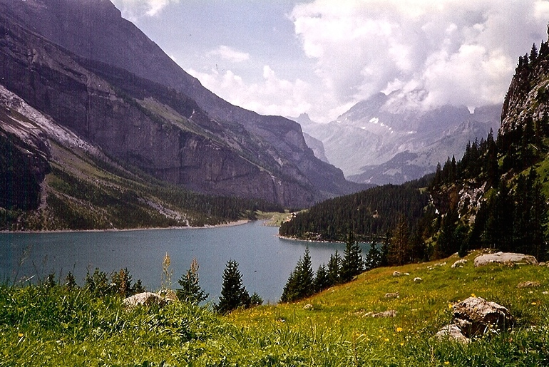
Lake Oeschinen | Switzerland, 1997
- As of 2016, the best online source for information is the ActivityWorkshop.net. This excellent site includes trekking notes, elevation profiles, waypoints, transport options, and accommodation recommendations. In fact, who am I kidding, you should probably go there right now. As per Swiss national, Wouter Bardelmeijer, another useful tool for hiking in Switzerland is the Switzerland Mobility App (https://www.schweizmobil.ch), which provides a detailed overview map of the country, GPX info for trails and routes, and links to public transport and accommodation.
- Another excellent online resource for the Alpine Pass Route is Wanderland.ch. This site contains much of the same information as ActivityWorkshop, in addition to a bunch of other information on anything and everything to do with hiking in Switzerland.

- Resupply: You can pick up provisions at all villages and towns. Even if you are camping, there is no need to carry more than a day or two’s food at any stage of the hike. Sometimes it’s also possible to purchase cheese and milk at the small farms along the way.
- Water sources are plentiful throughout the walk. Treat any water taken downstream of human settlement, grazing animals or agriculture (see Intestinal Disorders in HEALTH & SAFETY). Spigots on mountain ridges are ok to drink from, though you may need to wait your turn.

Route / Conditions :
- The Alpine Pass Route crosses sixteen mountain passes. There isn’t much in the way of flat terrain. According to the ActivityWorkshop.net, during the hike there is 19,600 metres (12.1 miles) of elevation gain and 19,500 metres (12.1 miles) of elevation loss. The equivalent of 2.2 Mt.Everest’s; just with lots more opportunities to load up on Lindt chocolate and fondue along the way. Speaking of which, if you happen to be on one of those non-dairy diets, this is probably not the hike for you.
- The way is marked by regular yellow and black signposts, which provide estimated hiking times to the next pass and/or village.

Yours truly on pass #7.
- In the year 2000, the Alpine Pass Route was amalgamated into a larger Trans-Alpine system of trails known as the Via Alpina. As a result, green signposts bearing the white number “1” and the title ‘Via Alpina’ now appear along much of the route.

Side Trips:
- Fans of Sherlock Holmes should not miss the side trip to Reichanbach falls. Situated close to the village of Meiringin, this is the place where Holmes and his arch nemesis Professor Moriarty had their final showdown. As a lifelong fan of Conan Doyle’s short stories, it represented one of the highlights of my walk!

- James Bond aficionados (I’m one of those too!) should walk or take the cable car from the village of Murren up to the Schilthorn (see photo below). This was Blofeld’s home base in On her Majesty’s Secrtet Service. Incredible views!

Sleeping :
- Wide array of options including mountain huts, hostels, hotels, organized campgrounds and guesthouse-type accommodation. If you choose to do so, you could definitely get by without a tent on this hike. See the ActivityWorkshop.net for detailed accommodation information.
- Although officially discouraged, “wild” camping is tolerated as long as discretion and no trace principles are practiced. In other words, set up your shelter at dusk, head off early the next morning and avoid camping too close to huts, villages or towns.


Overview :
- Hiking in Switzerland is like rambling through a big postcard come to life. Beautiful mountain scenery and charming centuries-old villages combine in a wonderful fusion of natural and cultural elements.
- This walk is not for those seeking long periods of solitude. Switzerland is a small country, and understandably many of its residents love to hike. In addition, you will most likely meet more than a few foreign hikers in the beautiful Bernese Oberland region.
- If you’re looking for some alone time, my advice is to bring your own shelter and do at least some of your hiking in the very early mornings and/or late afternoons. By doing so, you gift yourself the opportunity to experience one of Europe’s most beautiful alpine regions all to yourself.


Discover more from The Hiking Life
Subscribe to get the latest posts to your email.
This article definitely makes me want to go there and encourages me to do so.
Thanks Cam
I spent 3 weeks in Switzerland in August /Sept walking in Bernese Oberland and Zermatt – it’s a hikers dream and while not cheap wasn’t too bad on the wallet – ( maybe living in Western Austalia colours my opinion). Apart from in the vicinity of funicular stations and tourist attractions didn’t bump into too many other walkers. Flew from there to join my wife on the Camino – there definitely were a lot of walkers on that and Sarrio to Santiago was a procession.
Thanks again for a great website- it’s an inspiration
Mike Ainley
Thanks for the kind words!
I did the Alpine Pass Route in October 1990. West to east. It was magical!
Great info. I’m hoping to do this hike and work from the internet along the way. Do you know if you can get cellphone/internet along the route?
I did the hike in 1997, so I can’t say from personal experience. However, I’d be surprised if there weren’t plenty of places along the route where you would have cell reception.
Cheers,
Cam
If you choose the correct provider you’ll have cellphone/internet connection about 85-90% of the way. Maybe not always the fastest, but it’ll be there. You can forget wifi up in the mountains. For that you’ll have to go down in the valleys.
Amazing Idea! Were in zermatt area this summer and i love the hikes. So now i think i find my way back to that country ?
SO HELPFUL! Thank you so much for this information.
Thanks for the review. Thinking of going there in July but start from the Geneva Area.Which section do you think is the best for 8 days ? Thanka
Probably the central section through the Bernese Oberland region.
Intriguing. Sounds like a good way to dust off winter cobwebs. What’s the season for hiking this route look like?
Depending on the snow, late June to early October. September is ideal; good weather and not so many people on the trails as school holidays are over.
This hike looks terrific! I’m planning a 5-6 day hike at the beginning of September and thought part of this would be great to do (other option is half of the tour mont rosa). I think it’d be nice to finish around Grindelwald/Eiger area, so would you recommend coming from the east or west? We are looking for a challenging, beautiful hike and will be carrying all our gear (tent, etc.). In general what would your recommendation be for just some of this hike? We will be spending some days in the Lausanne area, so I’m not worried about not seeing Montreux and Lac Léman.
Either direction would be great, and by going in early September you will miss the school holiday crowds. You really can’t go wrong hiking in the Bernese Oberland – it’s a beautiful region! Best of luck on your trip.
Did this route in long sections this summer, just still have to go from Gstaad to Montreux (38 miles). Were the cow swamps also a problem 20 years ago? Mountain farmers seem to have geared up with their cows (heavier species), many pastures were really swampy and a mix from manure and deep holes in the ground. The ascent from Grindelwald to Jungfrau is near completely on asphalt and the tourist towns have a lot of new attractions for their obviously bored guests.
I’m looking at doing this September 2018. Everyone seems to mention going from East to West on Via Alpina. Is there a reason for this, or any problem going from Montreux to Sargans instead?
Not sure why most people go east to west. I’m not aware of any reason why one way would be easier than the other.
Hi Mike, I a will hopefully be doing the Alpina Pass this August 2018. I used to live in Vaduz, Liechtenstein which is very close to Sargans. I have done tons of local unknown to tourist day hikes throughout Liechtenstein and the Sargans valley. Your post has brought back so many nice memories I had while living there. Hopefully, I can relive some of these memories while visiting again this year.
Karen
Portland, ME
Ummm.. Sorry, I failed at multitasking… I meant to say Hi Cam and not Hi Mike. Sorry about that. Karen
Best of luck on your hike this year, and glad the post brought back some good memories!
Cheers,
Cam aka Mike 😉
Hi Cam aka Mike (haha),
I noticed you haven’t hiked in Romania. I just got back from Romania and there seems to be alot of hike trails. The areas I was looking into were the Bucegi Mtns and the Piatra Craiului National Park, and Poiana Brasov. However, Romania has lots of bears.. like Alaska but no grizzlies. So, people have cautioned me to hiking alone in these trails without having lots of bear protection… I have really liked the Brasov area which is in Transylvania… still old world charm, 14th century fortressed walls, gothic churches, forts, clock towers, etc….a little pagan and wild, and not too touristy..yet…
If it does pique your interests, let me know your feedback.
Regards,
Karen
Hey Karen,
Romania certainly does pique my interest. It is a place I have thought about going for many years. I remember picking up a copy of a “Hiking Guide to Romania” by Bradt publications in a bookstore in Brisbane almost two decades ago. I still have the book, though I suspect some of the logistical info may be a little bit outdated. Hopefully I’ll make it there sometime in the not too distant future.
Thanks very much for the message!
Cheers,
Cam
Hi Karen,
I’m going to be on the Alpine Pass at roughly the same time as you August/September 2018. I’m looking at continuing on into Liechtenstein and then going to Munich (likely by train/bus). Would love to hear more about the area, learn anything useful, share experience. If you want, or anyone else who’s interested, feel free to connect with me at Facebook.com/kevine
Hi Cameron!
Fred the sepo tank here. Came across your site. What a treasure!
:-)…hope all is well! I’d love to get back to the AP route and actually do the whole thing before time gets too far by.
Hey Fred,
Talk about a blast from the past……great to hear from you! I can’t believe it’s been almost 22 years since we hiked together in Switzerland. Hope all is well with you in the States. I also hope you make it back to the Alps one of these days to finish off the rest of the Alpine Pass Route.
Thanks a lot for dropping me a line. You just made my morning!
Cheers,
Cam
Hey, I did it! It was about 2 years ago when I read this and thought I would go last year, but ended up going this September-October (and ended up going East to West after all). Some tips from my experience…
1) Definitely use the Maps.cz app and download the maps for offline use. Via Alpina as well as other alternative trails are fully complete in the app making navigation a complete no-brainer.
2) Book your rooms in advance. I was late season and in some areas post-season so some huts were closed and in other areas places were swamped with tourists (Asian holiday). I was afraid to book too far in advance because I didn’t know what my pacing would be. This was a mistake. I should’ve just booked based on being able to keep the schedule in the workshop.
3) You’re never far from public transportation. If accommodations are a problem, you can easily get a train/bus/gondola to someplace else, spend the night and come back to resume your hike. Likewise, there are places off of Via Alpina that are worth checking out and are very easy to get to by train if you want to take a break from hiking.
4) Post Restante is your friend. You can go to any Die Post, La Poste, La Posta (post office) and send a package to another post office for pickup. I had a backpack with stuff from Oktoberfest and other stuff I wanted after the hike and they just took the backpack as is (no box or anything) and sent it ahead to Montreux. There’s a Die Post in Sargans that’s very close to the train station along the way to the trail. You can also ship to many places along the way if you want any special supplies.
5) The workshop is a fantastic starting guide. However, you’ll find that there are many alternative routes along the way. One of the things that took me a while to get used to was trying to be overly precise in navigating and following the right trail. I’m hesitant to say that you can’t get lost, but I found it much more enjoyable when I came to trust Mapy.cz and my own instincts on which routes to take. This is especially true when it comes to viewing the topography and deciding whether or not you want to go a short steep route or a longer flatter route.
6) There are Via Ferratas along the way (Mürren has a really spectacular one). You can do these yourself if you’re experienced and have the equipment, but there are also shops with guides and rental equipment.
7) It’s only a little bit further, but worth it in my opinion to get off the train in Sargans and cross over the river to start in Liechtenstein (it adds about 3 flat miles). Likewise, I ended in Saint-Gingolph, France (which is a charming little village with a ferry to Montreux).
Anyway, thanks Cam and others for the advice and inspiration. It was an amazing journey!!!
Congrats, Kevin! And thank you very much for such detailed and up-to-date feedback.
check out this app: https://www.schweizmobil.ch .
it’s a free app with just about all the information you need for hiking in Switzerland.
it provides:
-a good quality nation wide map. (for 35chf. a year you can download maps on your phone for offline use)
-information including GPX on all routes and trails your looking for.
-links to public transport and accommodation.
I live in Switzerland and use this app for all my research, and for navigation on trail.
Thanks, Wouter. I just added the link to the post.
Hi
A group of 20 or so of us from 249 Signal Squadron (British Army) did this route in June 1984 prior to our winter training in the arctic. We split into two parties one leaving from Montreaux, the other from Sargans, meeting up in the middle for a beer or two.
This remains one of the best long distance hikes I have done, probably only bested by the Grand Canyon.
We used a book written by Jonathan Hurdle as our planning guide, still have it in fact.
Wild camping was the main end of day routine but did use a regular camping site in Montreaux on the last leg. Farmers were always offering access to a barn or a field.
We were always met with a friendly face and advice, even if it was offered in 3 languages:)
The route described here ends at the terminus but we went to the lake and just dived off the pier. That’s how to end a hike.
Hi Andy,
What a great message! Thanks for taking the time to share your story.
Cheers,
Cam
Hi Cam,
Do you remember if there was a lot of loose rock sections on the trail requiring high walking boots or if you think it’s fine to do this in trail running shoes?
Cheers,
Thomas
Hi Thomas,
I think you’ll be absolutely fine in trail running shoes.
Cheers,
Cam
Thanks Cam
Hi Cam,
This is a great read and sounds like an amazing experience, thank you for sharing! I am planning on doing a hike across the Alps this summer by myself. I am considering either this route or the MySwitzerland route. The MySwitzerland route is deeper in the alps than this which intrigues me more, but it is also more difficult because of the large elevation changes. Although I love hiking, and during the summer go often hiking in the alps, I have never hiked for two or more days in a row. So my question is, how difficult was this? Did you have to do a lot of preparation for it? I don’t want to make the mistake of underestimating the Alps.
Thank you.
Kind regards,
Paolo
Hi Paolo,
Thanks for the message. How challenging the hike is depends on a number of factors including the fitness and experience of the aspirant. From a planning perspective, things have changed a lot since I did the hike in 1997. These days there is quite a lot of information online to help you with your preparation. Worst-case scenario, if you get into trouble while out on the trail, you are rarely more than a few hours away from the next village.
“I don’t want to make the mistake of underestimating the Alps.”
That’s good advice for any mountain trip.
All the best.
Cam