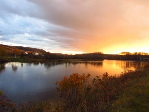
Sunset over the Restigouche River.
Distance: 171 miles (275 km)
Time: 4.5 days (Oct.12-16)
Daily Average: 38 miles (61.1 km)
Total Distance: 510 miles (820.6 km)
Highlights:
- Mt. Carleton State Park – this 12 km loop was the only real off-road hiking in all of New Brunswick. Unfortunately, the weather was not kind to me. When I arrived at Nictau Lake the sun was shining; within 20 minutes the storm clouds had rolled in and the remainder of my time in the park was spent getting absolutely drenched.
- Hospitality – When I look back on the NB section of the IAT, first and foremost I’ll remember the people I met along the way. Serendipitous encounters seemed to occur each and every day. A huge thanks to Bart, Mike, Stella at the “Belle Etoile” in Kedgewick, and last but definitely not least, Eileen from the wonderful Kringles B&B in Perth.
Lowlights:
- Road walking – Lots of it. The one saving grace was that much of this section was along an old railroad bed and thus traffic free (except for ATV’s). From a purely hiking perspective, one of the least enjoyable sections of “trail” I have ever hiked.
Notes & Musings:
- Funding: Unlike the Quebec section of the IAT which is well maintained, has regular refuges/campsites and receives funding from the provincial government, the stretch through New Brunswick is run solely by a volunteer organization. According to the IAT Companion Guide, the NB government withdrew all support for the trail in 2002.
- The River: For the section between Kedgewick and Matapedia, I would recommend future IAT Northbound hikers to take the canoe option down the Restigouche River. Quite frankly, it would be a much more enjoyable than walking along the roads/railroad bed.
Discover more from The Hiking Life
Subscribe to get the latest posts sent to your email.