At a Glance
Date: December 6-12 ( 6 days)
Start: Batopilas
Finish: Cumbres de Sinforosa
Distance: 130.5 miles (210 km)
Daily Average: 21.7 miles (35 km)
Total Distance: 381 miles (613 km)
The Highs and Lows of the CCT
We reached the fog-shrouded village of El Realito on the morning of December 8. Our original plan had been to follow the Rio Verde for 3 or 4 days and then climb out of the Sinforosa Canyon to our finishing point at Los Cumbres. Mother Nature had other ideas.

Descending to El Realito
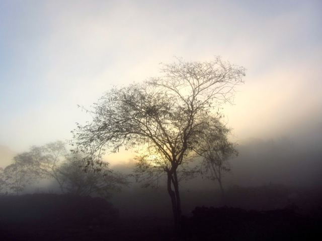
Sun breaking through.
Rivers were still running high. After studying our maps and consulting with a welcoming local family over coffee and freshly made tamales, we made the decision to climb 5000 ft out via a side canyon.
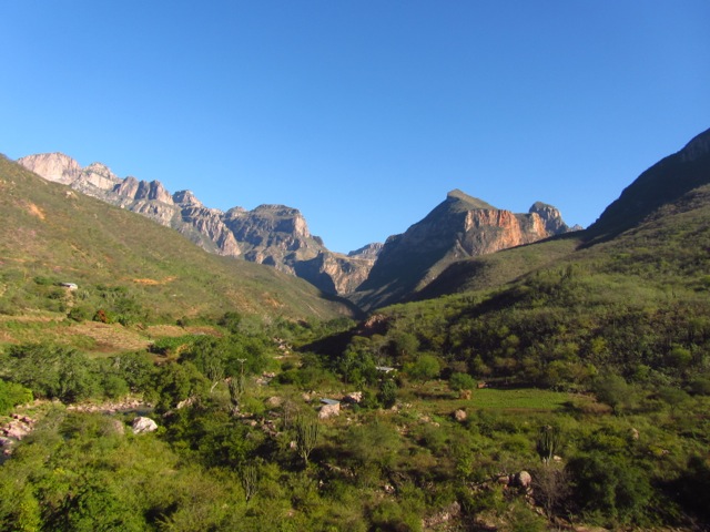
Leaving El Realito
We then skirted the northern rim of the Sinforosa before dropping back in via another canyon known locally as “El Pajarito“. Our point of descent put us above the confluence of the Rio Verde and the Rio de los Loera. This equated to lower water volume and easier fording opportunities.
During the aforementioned detour, we had an unavoidable four-hour road walk. Halfway along this section, we happened upon a couple of pounds of marijuana lying scattered along a 15 ft stretch of highway. A little surreal; it’s not every day that you see thousands of dollars worth of drugs lying randomly on the side of a road. It proved to be a sign of things to come.
Strange things you see on the side of the road.Post-Harvest in the Sinforosa
The final two days of the CCT were mostly spent tip-toeing our way through a number of well-tended “agricultural” plots. The crops of choice were marijuana and poppies. Thankfully harvest season had recently finished, so the only people manning the fields were cheerful campesinos who were apparently more than happy to help us out with any and all directional queries.

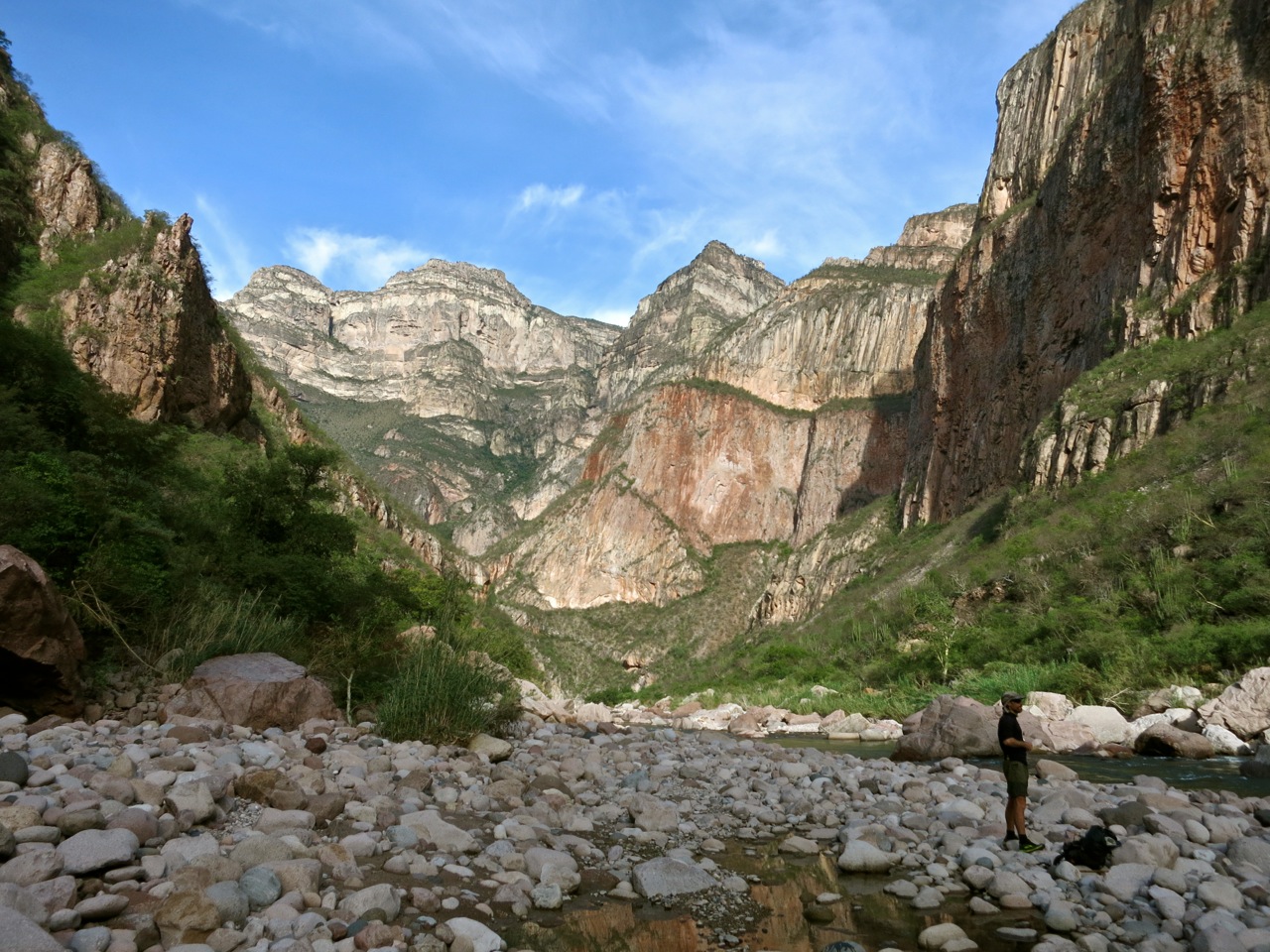
Justin Lichter descending into the Sinforosa.

Cam Honan | Waterfall campsite | El Pajarito Canyon
None of them could remember seeing a foreigner in these parts for many a year. Not sure we would have encountered the same warm fuzzy greeting if we had arrived a month earlier when the crops were being taken to market. Timing is everything in the Copper Canyon.
“Hey Bear”: Copper Canyon Remix
In order not to surprise anyone whilst walking through the drug fields, Justin and I regularly called out “Hola, Que Tal” or “Buenos dias/tardes.” For all intents and purposes, it was the Copper Canyon equivalent of repeating “Hey Bear”, a mantra commonly heard amongst hikers in grizzly or black bear country in the United States and Canada.
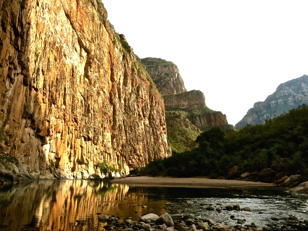
Sinforosa Canyon (photo from Justin Lichter)
The Decline of a Running Culture
The CCT represented my fifth hiking trip in the Copper Canyon region since 1995. One of the biggest changes I have noticed in those 18 years has been the construction of dirt roads (often funded by drug, mining and logging interests) into areas that had hitherto been accessible only by foot.
Such “progress” is a double-edged sword. On the one hand, easier access means that numerous communities now have running water, electricity and the other commodities that people in western countries have long taken for granted. On the flip side, the changes have also acted as a catalyst to many Raramuri leaving behind their traditional lifestyle, in search of employment opportunities in towns and cities that have now become more accessible. This combination of roads and urban migration has inevitably lead to a decline in the Raramuri’s long-distance running culture.
Sinforosa Canyon (photo from Justin Lichter)
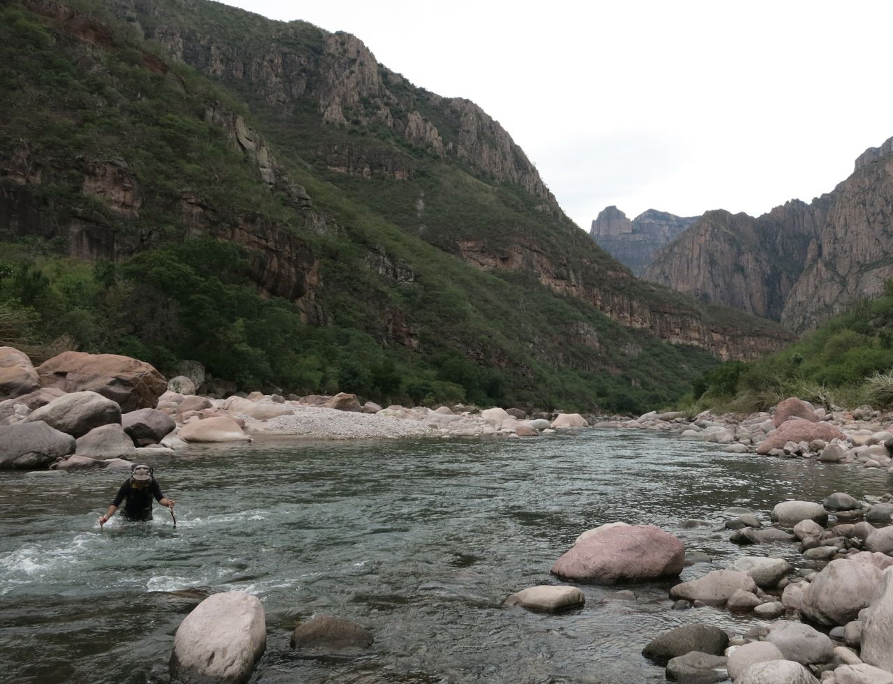
Fording the Rio Verde | Sinforosa Canyon
In the remoter corners of the Copper Canyon, many homesteads have been abandoned and certain paths that I remember hiking back in the 1990s and early 2000s are now completely overgrown due to lack of use. In the more populous zones, roads have often taken the place of trails. Whereas in times past people had no other option but to go on foot to the nearest village or town in order to purchase supplies, now they can hop into the back of a pickup truck and be there in a fraction of the time. Simply put, the necessity to run and walk long distances is no longer what it was for the Raramuri.
The End of the CCT
We arrived at the Cumbres de Sinforosa on the morning of December 12. The views over the canyon we had just climbed out of were amazing. I couldn’t imagine a better place to finish our trip.
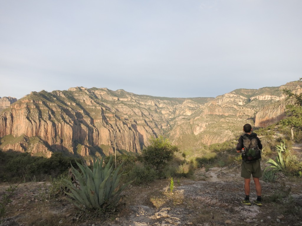
Ascending out of Sinforosa Canyon

Justin “Trauma” Lichter & Cam “Swami” Honan
During the CCT Justin and I covered close to 400 miles. To the best of our knowledge, it was the first-ever full-length traverse of the entire Copper Canyon region. An amazing trip in many ways, but one that ultimately left me with feelings of nostalgia. Whilst the scenery had been as spectacular as, during my first four visits, the relative absence of Raramuri out on the trails had left me with the sense that something had been missing. That the cultural and social shift that I alluded to above, had gained an anthropological head of steam during the past decade, and in some ways had reached the point of no return.
The Copper Canyon is a place that holds many memories for me. During my journeys to the region I’ve met a multitude of memorable characters, had guns held to my head and come within a proverbial whisker of falling off numerous cliffs. It’s been quite a ride. But undoubtedly the most indelible recollections have been those connected to the Raramuri. They were the primary reason I kept being drawn back to the Copper Canyon. The chance to observe, talk, eat, drink and even hike with them.
I have never encountered a people to match the Raramuri for their ability to cover ultra-long distances on foot. Not in the Himalayas, Andes, Pyrenees, Lapland, Atlas mountains or any other region known for the endurance of its native inhabitants. For a guy who loves to hike and be outdoors as much as I do, I consider myself very fortunate to have had the opportunity to visit and get to know both the region and its people, in a way in which not too many outsiders ever have.
Related Posts
- CCT Stage 1 – Basaseachic Falls to Creel
- CCT Stage 2 – Creel to Divisadero
- CCT Stage 3 – Divisadero to Batopilas
Discover more from The Hiking Life
Subscribe to get the latest posts sent to your email.
Wonderful trip!
– Do you have a gear list for the trip?
– Any marked maps of the trip, or more useful a GPS track of the journey?
– What, if any, would you do differently if you were doing it again?
I hope to do something like this within the next couple of year.
Saludos
Hi Carlos,
Thank you for the kind words.
To answer your questions:
– I didn’t put together a gear list for that trip, but it would be very similar to what I carried on the PCT & CDT (see gear list page). The notable exception would be that I carried a bigger backpack (MLD Exodus), due to the larger food carries (i.e we carried up to 8 days food at a time).
– We used maps (INEGI 1:50,000) and compasses for navigation purposes. We also took along a Garmin Foretrex GPS as a backup; a 2.2oz non-mapping unit which came in handy for checking coordinates on two or three occasions.
– In hindsight, there is nothing that stands out that I would do differently. The route was very scenic and challenging, however, due to drug-related safety issues (particularly in the Sinforosa), it is not a trip that I can presently recommend to others.
Saludos,
Cam
Hi Cam,
it looks amazing. I was this June (yes, it was crazy hot and dry) just this part: https://www.outdooractive.com/en/route/hiking-route/mexico/2021-05-mexico-barrancas-del-cobre/213281260/#dm=1
I am sure that December is better time to go. So, it looks, that you dont have any GPS or anything.. Its a pity, but I understand, how much work and planing it must have been.
Back in the late 70s and 80s when I did many trails running out of or leading to Batopilas and Urique, we had no GPS and only rarely the large-scale Mexican Army topos, so even with strong Spanish and rudimentary Raramuri, we spent a lot of time lost, up to a full day once, resulting in us running out of food for the last several days of the trip Cusarare-Batopilas via Barranca de Cobre. What I noticed in Batopilas in 2019, returning after 29 years in South America (Bolivia), Africa, and India, was many more Tarahumar living in the town of Batopilas. There still seemed to be good numbers of Raramuri on the La Bufa-Batopilas stretch. Congratulations once again on your truly epic hike!