Stretching along the eastern side of Hinchinbrook Island, the Thorsborne Trail is widely recognized as one of the world’s finest coastal walks. Part of Queensland’s Great Barrier Reef Marine Park, over the course of 32 km (19.9 mi), the track includes pristine beaches, lush rainforests, dense mangroves, towering eucalypt forests, and some of the finest tropical swimming holes this side of Tahiti. I hiked the Thorsborne Trail in 1997 and again in 2006. The second time around was part of a two-week scuba diving/hiking trip that included one of my all-time favourite dives, the SS Yongala (aka Australia’s Titanic). The photos below are from 2006, and all logistical details have been updated as of April 2020.
At a Glance
Distance: 32 km (19.9 mi)
Average Time: 3 days
Difficulty Level: Easy to medium
Start / Finish: Ramsay Bay – George Point
Which Direction?: It is possible to hike in either direction. Most hikers go north to south, though I don’t think it really matters from a difficulty perspective.

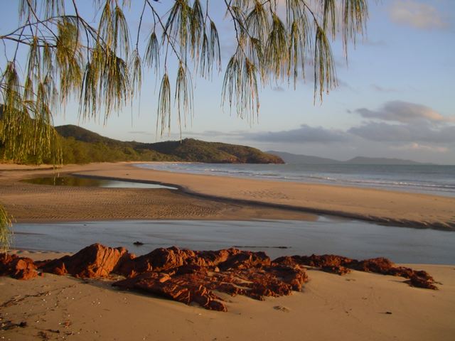
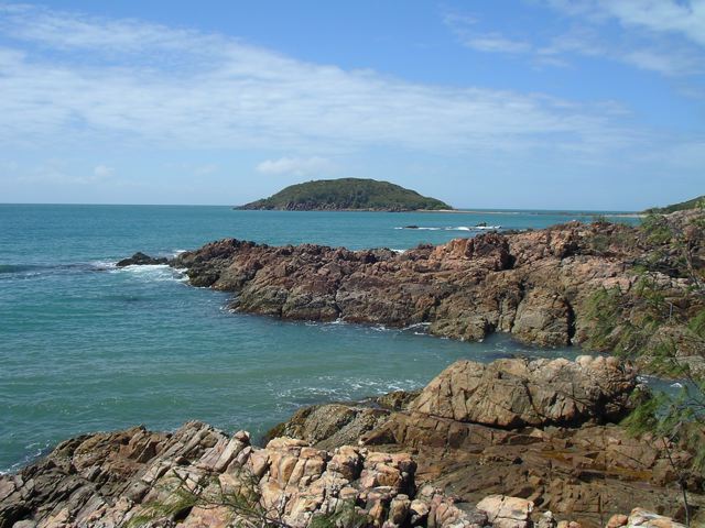
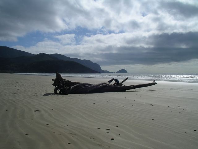
Loping along the beach at Ramsey Bay, near the northern terminus of the Thorsborne Trail.
Getting There & Away:
- Access to the Thorsborne Trail is via one of the commercial ferries, that transport bushwalkers to both ends of the trail from the mainland towns of Cardwell and Lucinda. Services can vary according to weather, tidal conditions and time of year, and you’ll need to book in advance. For all information in regard to company options, prices, and timetables, see the excellent Queensland Government Parks & Forests website.
Season:
- All-year-round. The cooler months between April and September are ideal. Summer means stifling heat and humidity, as well as the possibility of monsoonal rains.
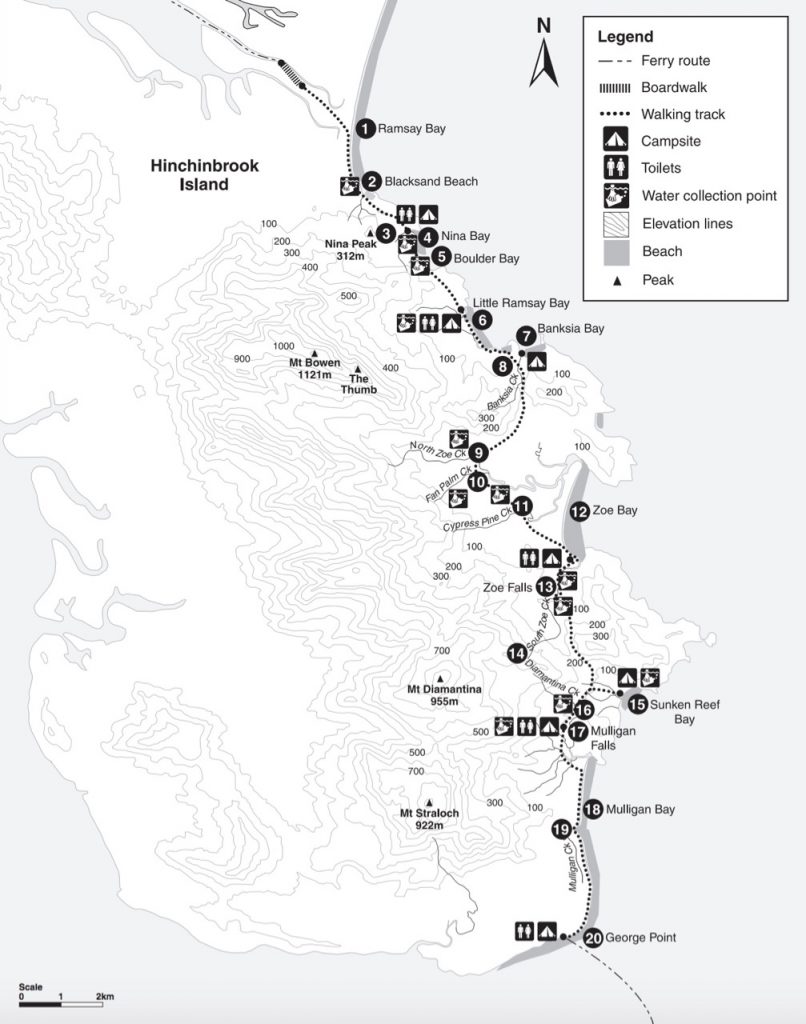
Thorsborne Trail Overview Map (free and downloadable from the QLD Government Parks & Forest website)
Maps / Information
- Background: Established in the early 1990s, the Thorsborne Trail takes place on Hinchinbrook Island, one of Australia’s largest island national parks. Part of the Great Barrier Reef World Heritage Area, the island is 37.4 km long, 10 km wide, and is separated from mainland Queensland by the scenic Hinchinbrook Channel.
- Permits: In addition to the boat services mentioned above, you’ll also need to organise camping permits for the Thorsborne Trail in advance. There is a maximum of 40 people allowed on the entire trail at any one time, and groups are limited to a maximum of six people.
- Supplies: Bring everything you need from the mainland. There are supermarkets in both Cardwell and Lucinda.
- Water is available in most of the island’s creeks but can become scarce during the dry season. Note that if you can’t find H2O at the trail crossings, you may have better luck further upstream. It is recommended that all water be filtered or treated.
- Map & Trekking Notes: The free and downloadable map on the QLD Government Parks and Forest website is all you need for navigation purposes on this very well marked and maintained track. The trekking notes on the same site provide a good overview of the trail. Note: If you are thinking of doing the excellent side trip to the summit of Mount Bowen (see below for details), it’s advisable to take a topo map and compass, and/or GPS. In regard to the former, a good option is ABC Maps, 1:50,000 Hillock Point sheet.
- GPS: See Aussiebushwalking.com and Alltrails.com for a GPX track for the Thorsborne Trail.
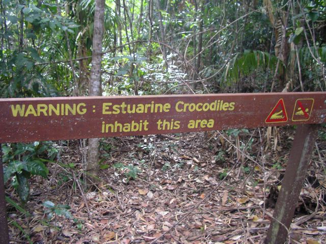
- Flora & Fauna: Hinchinbrook is home to a variety of animals including scrub fowls, skinks, dugongs, white-lipped tree frogs, green turtles, and the one that everyone both wants to see and doesn’t want to see…………..crocodiles.
You need to be a little selective about where you go swimming on Hinchinbrook.
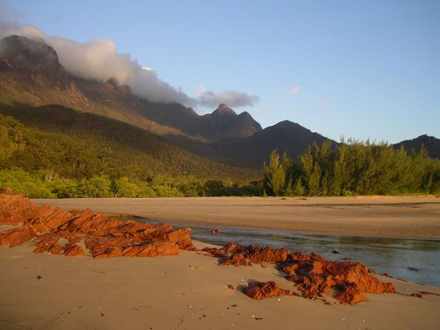
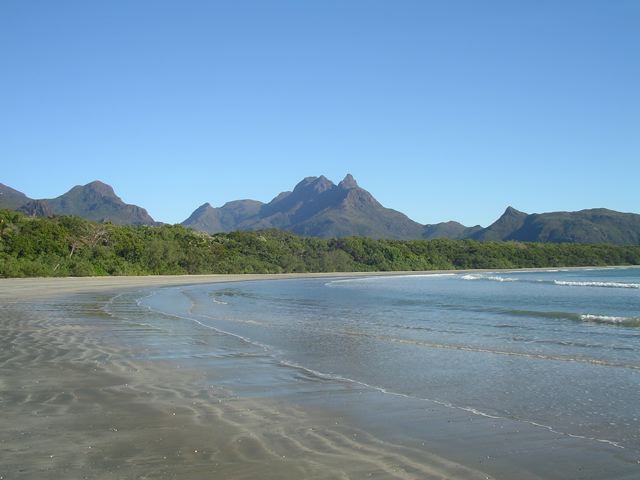
Early morning clouds creep through the island’s mountainous interior.
Route / Conditions
- Signage: The trek is well marked by orange trail markers from north to south, and yellow trail markers from south to north. Rock cairns are also used in areas where trail markers are absent.
- Stages: The QLD government website breaks the trail down into the following stages. At the end of each segment is a campsite and water source: 1. Ramsay Bay to Nina Bay (4 km); 2. Nina Bay to Little Ramsay Bay (2.5 km); 3. Little Ramsay Bay to Zoe Bay (10.5 km ); 4. Zoe Bay to Diamantina Creek (6.5 km); 5. Diamantina Creek to Mulligan Falls Camp (1 km), and; 6. Mulligan Falls Camp to George Point (7.5 km).
Black Sand Beach
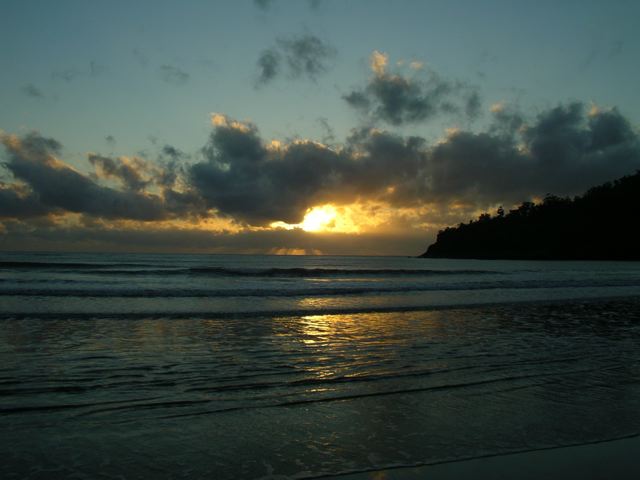
Sunrise over the Pacific Ocean
- Swimming – Part 1: The beaches along the trail are gorgeous, however, be sure to take heed of any saltwater crocodile warning signs. According to the QLD Government Parks and Forest Department: “……crocodiles can turn up anywhere in croc country, including tidal reaches of rivers, along beaches, on offshore islands and cays in the Great Barrier Reef and Torres Strait, and in freshwater lagoons, rivers, and swamps.” It’s also worth noting that dangerous stinging jellyfish (‘stingers’) may be present in the waters surrounding Hinchinbrook, especially during the warmer months of summer.
- Swimming – Part 2: If you are chomping at the bit for a refreshing swim, there are some great freshwater (and prehistoric reptile-free) opportunities to be had at both Zoe and Mulligan Falls.
- Side Trip to Mount Bowen (Note: I did this excellent out-and-back excursion in 1997, but regrettably skipped it in 2006 due to time restrictions): From Little Ramsey Bay Campsite it’s approximately 13 km (8.1 mi) return to the summit of Mount Bowen (1121 m / 3,678 ft), the highest point on Hinchinbrook Island. Departing the camping area, a cairned route makes its way up the rocky Warrawilla Creek bed before eventually ascending to the small North Saddle, where there is space for two tents (you’ll require a special camping permit). From this scenic point, follow the ridge south through scrubby forest, negotiating granite bluffs and some sizable boulders. When you eventually reach the summit you’ll be greeted by a large cairn, a summit logbook, and a gorgeous 360-degree panorama of Hinchinbrook Island (Note: There are other alternatives to ascending Bowen such as the Pineapple Ridge Route and the Nina Creek Route; see Wanderstories.space for details).
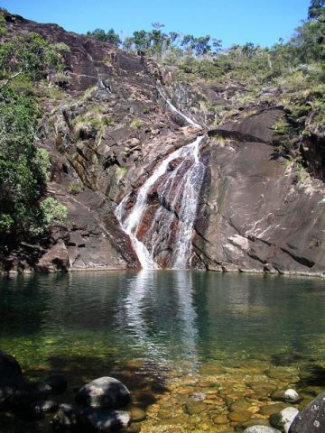
Swimming heaven at Zoe Falls.
Sleeping
- Bring your own shelter. There are seven designated camping areas on the Thorsborne Trail. A maximum of two nights is permitted at any campsite, with the exception of Mulligan Falls, where hikers are only permitted to stay for a single night.
- Due to rats, steel boxes are present at all the main campsites. Be sure to store your food in them at night, lest you wake up in the morning with a hole in your tent and/or pack.
- See the Thorsborne Trail Camping page on the QLD Parks & Forests website for details on each of the respective campsites.
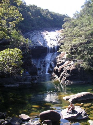
Mulligan Falls
Overview
- Mangroves, pristine beaches, towering Eucalypt forests, rocky headlands, lush rainforest, and two legendary swimming holes – the Thorsborne Trail packs an incredible amount into just 32 km (19.9 mi).
- Due to its short length, mellow nature and the logistics of actually getting to and from the island itself, I would highly recommend taking your time on the Thorsborne Trail. Bring a book, catch every sunrise, do as much swimming as possible, and don’t miss the side trip to the summit of Mount Bowen.
Crystal clear water at the base of Mulligan Falls.
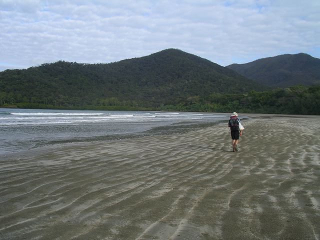
Hiking along the final stretch of coastline towards George Point.
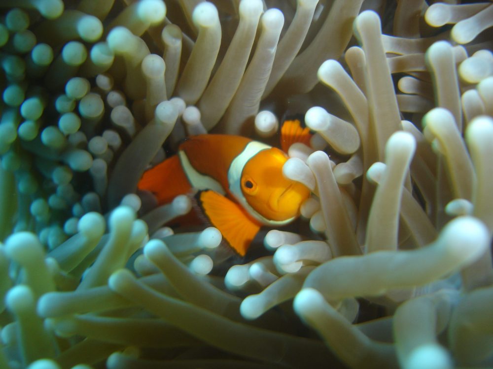
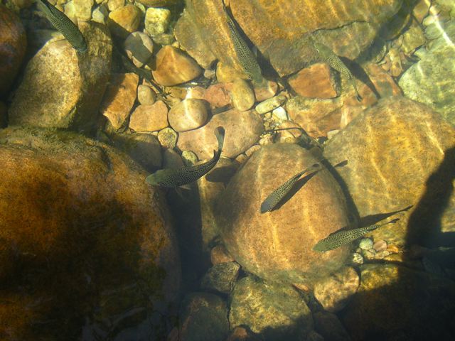
Bonus Image – Finding Nemo during my post-hike dive of the SS Yongala. Speaking of which…….
Gear List for the Thorsborne Trail (Winter, 2020)
Here is a rundown of what I would take if I was to hike the Thorsborne Trail again in 2020.
| ITEM | WT. (OZ) | SUB (oz) | SUB (kg) | COMMENTS |
| BACKPACK | ||||
| MLD Burn (DCF) (modified) | 15 | Frameless, slim profile / UL backpack of choice since the 2000s / Current model has more bells and whistles than the original version, but no biggie to modify (see Pack Hack video). | ||
| Pack Liner (Trash Compactor Bag) | 2 | Cheap and effective | ||
| 17 | 0.48 | |||
| SHELTER | ||||
| Tarptent Aeon Li | 16.8 | Easy to pitch and roomy for something that weighs around a pound. The bathtub floor and netting are key for wet, muddy, and buggy (oh my) conditions. If rain isn’t on the cards, I leave door flaps completely rolled up for more ventilation and enhanced views (see photo below). | ||
| Stakes – Easton stakes (come with tent) | 1.7 | |||
| 18.5 | 0.52 | |||
| SLEEPING SYSTEM | ||||
| Pad – Thermarest NeoAir XLite (Sm) | 8 | Very comfy / Doubles as makeshift framesheet for pack / Put feet on backpack when sleeping / See 20,000 + mile review. | ||
| Quilt – MLD Spirit Quilt 38°F (Lge) (with Poncho head slot) | 19 | I prefer synthetic over down insulation in hot/humid environs (see UL Backpacking Gear in Hot and Humid Weather for details). | ||
| 27 | 0.77 | |||
| KITCHEN | ||||
| LokSak 20×12 (Food Bag) | 1.2 | Holds up to five days of food. I’ve found that seals start to go after about six weeks of regular use in the field. | ||
| Food Vessel: Reconstituted Gatorade Powder Container | 1.8 | |||
| Titanium spork (Toaks) | 0.2 | I put some orange tape around the end to make it tougher to lose. | ||
| SmartWater Bottles 1 LT (2) | 2.6 | |||
| 5.8 | 0.16 | |||
| FIRST AID / HYGIENE | ||||
| Sunscreen (repackaged in a tiny bottle) | ||||
| Hand Sanitizer (repackaged in a dropper bottle) | It’s been 20 years since I’ve had a case of the trots in the backcountry. I think a big reason is my diligent use of hand sanitizer. | |||
| Aquamira (repackaged in dropper bottles) | Water purification method of choice since 2007. | |||
| Mini Toothbrush | ||||
| Toothpaste (mini tube) | ||||
| Dental Floss | Doubles as sewing thread | |||
| Antiseptic Wipes (2) | Clean cuts and wounds. | |||
| Gauze | ||||
| Triple Antibiotic Cream (tiny tube) | ||||
| 3M Micropore Medical Tape | Breathable, paper tape / Adheres well. | |||
| Ibuprofen (6) | ||||
| Sewing Needle | One-armed blind people can sew better than I can. | |||
| Tenacious Tape and Mini Tube Super Glue (sleeping mat repair) | ||||
| 4 | 0.11 | |||
| CLOTHES | ||||
| Rain Jacket – Montbell Versalite | 6.4 | Pit-zips, two pockets, 3-way adjustable hood / Combine with travel umbrella when it’s really bucketing down. | ||
| Insulation – Patagonia Capilene Thermal Weight Zip-Neck | 6.5 | Versatile. Can be used as a mid-layer in hot conditions (size up), or a base layer when temps are around freezing. | ||
| Extra Socks – REI Merino Wool Liners | 1.4 | Still my go-to liner socks, though the current models aren’t quite as durable as the pre-2013 versions. | ||
| Head Net – Sea to Summit with Insect Shield | 1.3 | |||
| 15.6 | 0.44 | |||
| MISCELLANEOUS | ||||
| Phone -iPhone 11 | 6.8 | Major upgrade over my old Samsung Galaxy S7 | ||
| Otter Symmetry case (orange) | 1.3 | |||
| Umbrella – Montbell Travel Umbrella | 3.0 | More of a supplementary item rather than a stand-alone solution for all my rain protection needs. Combines well with rain jacket. Sanity saver when it’s belting down for an extended period. | ||
| Small stuff sack – HMG Cuben Fiber (2) | 0.6 | Ditty bag / First Aid / Toiletries | ||
| Nitecore NU25 | 1.8 | Recent pickup. I’d been hearing great things about it for the last year or two, and decided to give it a try. Double thumbs up. | ||
| Montbell Trail Wallet (orange model) | 0.5 | Love this little wallet. Light and respectable alternative to the hikertrash/homeless Ziploc model. Use it both on trail and off. | ||
| Swiss Army Classic | 0.7 | |||
| Compass – Suunto M-3G Global Pro | 1.6 | Adjustable declination and globally balanced needle. | ||
| Map Bag – Quart Size Ziploc | 0.3 | Keeps maps clean, dry, and organized. | ||
| Montbell Alpine Carbon Pole Cam Lock (without strap and basket) | 6.8 | After many years of using the Fizan Compacts (twist lock), I switched to the Montbell flip-locks which are easier to handle, more secure, and worth the extra ounce and a half. | ||
| 23.6 | 0.67 | |||
| BASE WEIGHT | TOTAL | 6.9 lb | 3.1 kg | |
| ITEMS WORN | ||||
| Shorts – Patagonia Baggies 7″ | 6.7 | |||
| Base layer – Patagonia Sun Stretch Shirt (Lge) | 7 | I’ve been regularly using this shirt during the Australian summer in recent years. Material feels soft against the skin, relaxed fit, dries quickly, useful zippered pockets, and UPF 30 protection. | ||
| Hat – Adapt-a-Cap (old model) | 3.2 | The latest incarnation is heavier and a little tight for folks with a big noggin. | ||
| Shoes – Brooks Cascadia 14 | 23.6 | I’ve worn every model of the Cascadias since the 3’s, which came out more than a decade ago. With the exception of the Cascadia 10’s, all of the different incarnations have consistently given me between 450 and 600 miles before having to swap them out. | ||
| Socks – REI Merino Wool liners | 1.4 | Still my go-to liner socks, though the current models aren’t as durable as the pre-2013 versions. | ||
| Dirty Girl Gaiters | 1.2 | Handy for keeping out dirt and mud. Fun colours and designs. I’ve been rocking DG’s since 2007. | ||
| Timex Ironman Watch | 1.4 | Cheap, durable, light, multiple alarms | ||
| Sunglasses | 0.8 | Polarized lenses, 100% UV protection, wrap-around. | ||
| 46.2 | 1.31 | |||
| TOTAL WEIGHT | 9.8 lb | 4.4 kg | ||
Disclosure: This post contains some affiliate links, which means The Hiking Life receives a small commission if you purchase an item after clicking on one of the links. This comes at no additional cost to the reader and helps to support the website in its continuing goal to create quality content for backpackers and hikers. Cheers.
Discover more from The Hiking Life
Subscribe to get the latest posts sent to your email.
Hi Cam great article Peter&I did the walk a few years ago as you said a real joy
Hope your well best wishes
Max&Glen McDonald
Hi Max,
Thanks for the kind words. The Thorsborne is definitely a gem of a hike; one of Queensland’s best. Hope you, Glen, and the whole family are also doing well.
Cheers,
Cam
It looks like a beautiful hike. Thank you for sharing.
Brings back some happy memories. I had a spare day at Zoe Bay and well worth it. Spent the day swimming at Zoe Falls, photographing and relaxing.
I really want to do this hike in the September school holidays 2020 but it’s completely booked out apart from 1 night. I need a minimum of 3 nights so if anyone is booked to go during this period but has changed their plans, please please let me know so I can grab your spot 🤞🤞
Thank you for sharing your incredible hiking experience on the Thorsborne Trail on Hinchinbrook Island! Your stories and photos have left me in awe of the trail’s breathtaking scenery and challenging terrain. Your insights are valuable, and I’m sure many future hikers will benefit from your expertise. Congratulations on completing the trail, and thank you again for sharing your adventure with us!