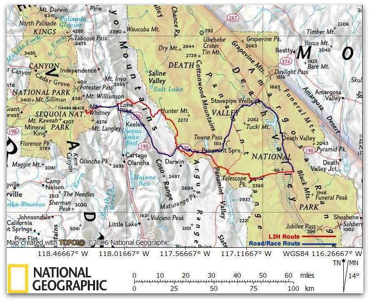
Lowest to Highest Overview Map (Route in red)
Death Valley to the summit of Mt.Whitney.
From the lowest spot in North America (280 ft below sea level) to the highest point in the contiguous United States (14,495 ft).
The brainchild of Brett “Blisterfree” Tucker (creator of the Grand Enchantment Trail), the approximately 135 mile journey takes the hiker from salt pans to snowy peaks via a combination of trails, lightly used 4WD tracks and cross-country travel.
The ‘Lowest to Highest’ (L2H) proved to be a memorable trip in many ways, not least of which was the geographic diversity encountered throughout the journey. Salt flats to granite peaks, Joshua trees to Lodgepole pines; for a relatively short hike, the contrasts were amazing. For a detailed trip report, see the following writeup from Ryan “Dirtmonger” Sylva, one of my three hiking companions (along with Bobcat & Malto) on the L2H: http://freedirtmonger.blogspot.mx
From a personal perspective, the route from Death Valley to Whitney was the first time in many years that I had trekked for an extended period with more than one person. It turned out to be a great experience. The four of us hiked in a similar style, at a comparable pace, and the entire trip was marked by an easy going atmosphere in which the hours flew by. Thanks to DM, Bobcat and Malto for helping to make a great hike even better.

(L to R) Dirtmonger, Malto, Swami, Bobcat
Finally, I’d like to acknowledge the amazing job that Blisterfree has done in putting this route together. As with his Grand Enchantment Trail from Phoenix to Albuquerque, Brett, who’s trail name should be the “Water Diviner”, has managed to create a scenic and challenging backcountry route by linking together obscure water sources in one of the driest regions of the United States.
Trip Summary

Joshua “Bobcat” Stacy looking out from the Inyos Mountains | Lowest to Highest Route | 2014
Dates: April 5 to 10
Distance: 135 miles (217 km) – plus 11 miles return to Lone Pine Campground from the summit.
Time: 5.5 days
Start / Finish:
- Badwater, Death Valley, CA.
- Summit of Mt.Whitney
Maps / Info:
- http://www.simblissity.net/L2H.shtml. One stop shop. Includes elevation profiles, water information, maps, waypoints, etc.
- Prior to the trip we contacted the Furnace Creek Visitor’s Centre (760-7863200) in order to obtain up-to-date information in regards to water (see below).
- Resupply: We resupplied at the small store in Panamint Springs Resort, which also sports a decent restaurant and motel/campground. Call them beforehand if you are interested in sending a package there. Pickings were slim, so if you are a little on the choosy side when it comes to your backcountry diet, you may be better off going the postal option.

Death Valley at midday.
- Temperatures: Quite the range. Death Valley is the hottest and driest place in North America. Mount Whitney is a 14,000 ft plus peak. We were prepared for scorching hot to below freezing conditions. However, Mother Nature was kind to us; temps in Death Valley did not get above the 80’s F (27 C +), nor did they dip below the high 20’s F (-2 C) in the Alpine zone.

Cam Honan with a Montbell UL Trekking umbrella.

Final stretch before Panamint Springs
Route / Conditions:
Water
- Water is key for the first 107 miles of the L2H (i.e. Until you hit the town of Lone Pine).
- Malto stored a water cache for us at mile marker 68 on Saline Valley Alternate Road.
- By hiking in the spring, despite the recent drought conditions in the southwest, we had access to more water than folks hiking in the Fall. Here is a quick summary of the water sources mentioned on Brett’s website:

Small cascade adjacent to Darwin Falls.
- Hanaupah spring – According to local information, this is a year round source. Good flow. I highly recommend following the south fork of Hanaupah canyon until you reach the spring, rather than taking the more direct ridge when the canyon splits at the 12.3 mile mark.
- Tuber Canyon – Marginal source. We obtained water here, however, I wouldn’t be counting on this source if I was hiking in the Fall.
- Darwin Canyon & China Garden Spring – Year round; water should be treated.
- Mexican Spring – Another marginal source; we were able to top up here from the snowmelt, however, I have my doubts you would find water here in the Fall.
- Long John Canyon Spring – Small flow; good water, but once again not to be relied on if hiking later in the year. Thankfully, once you reach this point you only have 4 miles to go until you reach the town of Lone Pine.

China Garden Spring
Snow
- From Whitney Portal, we took the Mountaineer’s route to the summit.
- We all carried ice axes and microspikes.
- After attaining the notch, 300 ft below the summit plateau, we chose to ascend the final section via the chute immediately to the left of the notch.

Bobcat & Dirtmonger on route to Whitney.
- We descended from the summit via the Mount Whitney Trail. Upon reaching Trail Crest, we glissaded more than 1200 ft down to the basin below.
- From this point we postholed for the best part of three hours, reaching snow-free terrrain only a handful of switchbacks above the Whitney Portal campground.
Click here for photo galleries from the Lowest to Highest Route.

Cam Honan on the final ascent up to Whitney summit (photo by Joshua Stacy).

Heading back to Whitney Portal.
Discover more from The Hiking Life
Subscribe to get the latest posts sent to your email.