The Pyrenean Haute Route (or HRP for Haute Randonnée Pyrénéenne) is an approximately 800 km (497 mi) traverse of one of Europe’s most beautiful mountain ranges. Stretching from the Atlantic ocean to the Mediterranean sea, it crisscrosses the natural boundary between Spain and France, staying close to its watershed throughout most of its undulating course.
Pyrenean Haute Route (HRP) Overview map (Cicerone Press)
I hiked the HRP in 1999 with a Kiwi mate of mine by the name of Dave. Back then information was scarce, however, in recent years this spectacular coast-to-coast route has gradually emerged on the world’s backpacking radar. The following article includes logistical beta, planning tips, side trip recommendations, and an overview of the hike. All information is current as of July, 2018 (Note: Please excuse the grainy images. With just a couple of exceptions all photos were taken in the pre-digital age, and were subsequently saved from “shoebox purgatory” in 2010 when I put together The Hiking Life website).
At a Glance
Distance : 800 km (497 miles) approx.
Avg.Time : 45 days
- The time needed to complete the HRP can vary a great deal. Fit and speedy hikers carrying a light pack can do it 20 to 25 days. Slower and/or more heavily laden folks that are interested in doing as many side trips as possible may take 50 days plus.
Start / Finish :
- Both trailheads are easily accessible via regular public transport (planes and trains).
Ready to begin the HRP! Yours truly at Hendaye on the Atlantic coast in July, 1999.
Season : Late June to September.
Difficulty: Moderate to challenging
Highest Point: Col Inferieur de Literole – 2983m (9787 ft)
Lowest Point: Atlantic Ocean and Mediterranean Sea
Approx. Overall Elevation Gain: 42,350 meters (139,000 feet)
Countries visited: 3 – France, Spain and Andorra.

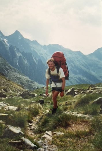
Hauling the monster-sized Dana Designs Terraplane (3.3 kg / 7.28 lbs) through the Pyrenees.
Maps, Guidebooks & GPS
In 1999 we used a combination of Georges Veron’s, Pyrenees High Level Route (1990 – now out of print) and the French IGN series 1:50,000 Topographical maps. Unable to find topos for the Spanish side, we made do with the sketch maps in Veron’s bare-bones guide while hiking on the southern side of the border. Current options are as follows:
- Guidebooks: Ton Joosten’s, Pyrenean Haute Route (2nd edition, 2013), published by Cicerone Press. Available on Kindle as well. For French speakers, an alternative is Jérôme Bonneaux’s, “Trans’Pyr”. For those interested in shorter hikes in the range, also available from Cicerone Press are Walks and Climbs in the Pyrenees (2015) and The Pyrenees (2010).
Dave entering Andorra.
- Maps: Your best and definitely cheapest bet would be to print out maps from Caltopo or GaiaGPS and use them in combination with the Cicerone guidebook. Alternatively, there is a set of 25 /1:50,000 sheets (with GPS compatible topographic base) from Rando Editions that cover the route. These can be purchased online from Omnimap or Stanford’s. Note that all 25 may not be in stock when you need them, and as of 2018 each map will set you back around US$17 to US$20. In other words, save yourself some cash and print out the freebies from Caltopo or Gaia on 11×17 sheets.
- GPS Data: 1. Caltopo – Route, Campsites, Refuges; 2. Caltopo 2 – From the Doing Miles website (see below); 3. Wikiloc – Steve Cracknell’s 2016 HRP hike.
- Online Resources: 1. Amy & James, Doing miles – Excellent overview of the trail, logistics, and GPS data; 2. Steve Cracknell’s, Lasneda.net – General info and journals from a guy that has walked all three of the trans-Pyrenean routes – HRP, GR10 and GR11 (see Map below); 3. Andy Howell, Pyrenees Hiking Information – General overview of hiking in the Pyrenees 4. Pyrenean Haute Route Facebook Group; 5. Walking with Wired – Logistics, GPS info, trail journal; 6. Viajar a Pie– Detailed overview of the HRP. I recently had a good look at this site and it contains lots of useful information on gear, skills and a bunch of different hikes from around the world. I just added it to my list of recommended Websites for Hikers and Backpackers, and; 7. HRP Pocket Guide – As of April 2020, Paul Atkinson’s guide seems to be the most comprehensive online resource for the HRP. It includes a detailed route description (both west to east, and east to west), GPX and KML files, time/distance/elevation estimates, and resupply information.
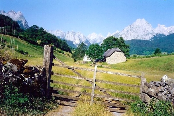
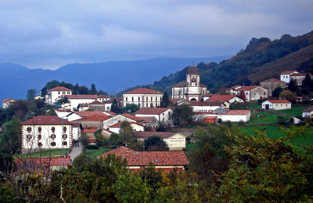
Leaving the village of Lescun.
General Information
- Accommodation: A wide range of accommodation is available including regularly spaced huts in the mountains (both staffed and free), as well as gite d’etape and hotels in the villages (see the Cicerone guide for details). Most of the mountain huts have free designated camping areas close by. These spots come in handy if you plan on eating some of your meals at the refuges (see Costs below for details).
- Wild camping is possible throughout the route. In France, they call it ‘bivouacking’ – setting up your shelter late in the day (after 7 pm) and heading off again early the next morning. Be sure to do so away from villages and out of sight of the trail.
- Do I need to bring a shelter?: People have hiked versions of the HRP completely sans tent/tarp, exclusively utilizing indoor accommodation along the way. However, during July and August some of the mountain huts can fill up quickly, therefore it is recommended that all HRP thru-hikers bring their own shelter. Not only will this provide you with a greater degree of accommodation flexibility, but also gifts you the freedom to soak in a beautiful Pyrenean sunrise and sunset from a secluded mountain perch whenever you choose to do so.
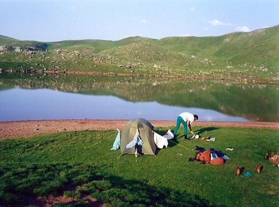
Camping near Refuge d’Arlet.
- Resupply: In all the villages along the HRP you can buy basic staples such as pasta, bread, sausage, cheese, yoghurt, cereals, canned tuna, and chocolate. Provisions can also sometimes be purchased at the staffed mountain huts, all of which serve hearty and reasonably priced meals. Thanks to the plethora of resupply options, on the HRP you should never have to carry more than one or two days food at a time unless you choose to do so.
- Post: Although it isn’t necessary to send resupply boxes on the HRP, for those who would like to have paper maps in addition to their electronic devices (recommended), consider sending map packages to the following villages: Lescun (end of Stage 1), Gavarnie (end of Stage 2), Salardu (end of Stage 3) and L’Hospitalet-près-l’Andorre (end of Stage 4). The cheapest and quickest way to do this is most probably from the post office in Hendaye before beginning your trek.
- Water: The villages along the route have fountains or pumps from which potable water can be obtained. While in the mountains it is recommended to treat any water taken downstream of human settlement, grazing animals or agriculture (see Intestinal Disorders in the HEALTH & SAFETY section of the website).

When it comes to gorgeous blue lakes, the HRP rivals the John Muir Trail and Sierra High Route in California’s High Sierra.
- Stoves: Cylinders for gas stoves can be found in the larger villages. If you are using an alcohol stove, you can pick up alcool à brûler (France) or alcohol de quemar (Spain) in supermarkets or hardware store in most small towns.
- Costs: As of 2018, dormitory-style accommodation in the refuges normally goes for about €15 a night. Continental-style breakfasts will set you back about €6, packed lunches €7, and hearty three-course dinners (soup/salad, pasta/rice/meat/potatoes, dessert) around €15. Add on an extra €4 for the semi-obligatory half litre of wine.
Dave heading up towards a rocky notch on the HRP.
- Fauna: The Pyrenees are home to a variety of wildlife including chamois, marmots, vipers, and lots of birdlife including bearded and griffon vultures, golden eagles and peregrine falcons. Perhaps its most famous creature is also its most endangered – the Pyrenean Brown bear (Ursus Arctos). The range was once home to a thriving population of brown bears, the last of which was said to have been killed in the early 1990s. Since then periodic attempts have been made to reintroduce the species into the range using bears from Slovenia. As of 2018, there were thought to be around 30 brown bears in the Pyrenees. The repopulation program of the French government continues to be strongly protested by farmers on both sides of the Franco-Spanish border, who blame the bears for the deaths of hundreds of their sheep.
- Almost forgot…….one of my favourite dog breeds come from the Pyrenees – none other than the massive Pyrenean mountain dog (also known as ‘Great Pyrenees’). Before hiking the HRP in 1999 I’d never heard of this beautiful canine. During the route, I saw three or four of them and was blown away by their size, power, keen intelligence, and kindly expressions. The two Pyrenean mountain dogs (Chase and Goliath) below belong to regular hiking partner and good mate, Greg “Malto” Gressel.

Route & Conditions
The Pyrenean Haute Route is bookended by the pretty seaside towns of Hendaye and Banyuls. In between lies 800 km worth of jagged granite peaks, sapphire blue lakes, flower-laden alpine meadows, and sweeping glacial cirques. Almost two decades after I hiked the HRP, it remains one of my all-time favourite trails:
- History & Character: The HRP is more of a concept than an established route. The idea for the hike was devised in 1968 by Georges Veron. Both his route and the Ton Joosten version (Cicerone Press) vary considerably. The main differences are that the former spends more time in France, coincides with the GR10 (see below) for longer stretches, passes through more villages, and spends less time on or close to the watershed. All that said, due to the fact that both Veron’s and Joosten’s high routes each have so many possible variants, it is rare that any two HRP thru-hikes end up being exactly the same. And that freedom to choose your own route is one of the coolest things about hiking the HRP.

Lacs d’Arriel
- HRP Vs GR10 and GR11: The HRP is one of three coast-to-coast routes that cross the Pyrenees. The other two are the GR10 in France and the GR11 in Spain, both of which are well defined and established trails that stay on their respective sides of the border (Note: All three routes also pass through the principality of Andorra). Unlike the other range-spanning treks, the HRP is sometimes trailless and largely unmarked; the GR’s are marked with red and white blazes. Further differentiating the HRP is the fact that it tends to stay high on the range’s crest, whereas the GR10 and GR11 constantly vacillate between alpine landscapes and low-lying valleys. While all three routes pass through spectacular environs, the HRP is the most challenging of the trio, and is best suited to fit and experienced backpackers with good navigation skills. On the other hand, the GR10 and GR11 (particularly the former) are more accessible to hikers of different levels of experience, and due to the fact that they finish each daily stage at a small town or village, represent better alternatives for those looking for more in the way of creature comforts from their long-distance hiking holiday.

GR10 (red), HRP (yellow), GR11 (blue) | This overview map is from an excellent article by Lasenda.net, in which the site’s author Steve Cracknell compares the three trans-Pyrenean routes.
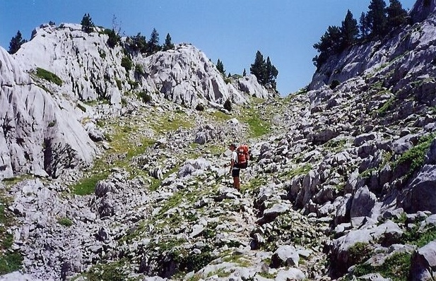
- Passes: Despite the fact that it stays high for much of its duration, don’t be fooled into thinking that there isn’t a lot of elevation gain and loss on the HRP. According to Cracknell, the HRP goes up and over 23 passes above 2500m (8202 ft), as opposed to just two for the GR10 and 12 for the GR11.
- Section Hikes of the HRP: If you only have a couple of weeks holiday and you want to experience some of the best that the Pyrenees has to offer, it’s hard to go past the stunning central part of the range between Lescun and Salardu (Stage 2 and 3 in the Cicerone Guide). A less popular, more difficult, and arguably just as beautiful section is between Salardu and L’Hospitalet-près-l’Andorre (Stage 4 of the Cicerone Guide).
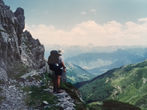
Taking in the valley views.
- Weather: As you would expect, it’s warmer at the lower, coastal ends of the Pyrenees, and colder in the higher central section of the range. During the trekking season of late June to September, once you head inland daytime temps typically get up to the mid-20’s Celsius (mid 70’s F) and drop down to single digits at night (mid 30’s to mid 40’s F). Summer thunderstorms generally roll through around 4 pm; which is obviously not the best time to be going over one of the high passes (i.e. plan ahead).
- Snow Conditions: One of the most common gear questions regarding the HRP is, “do I need an ice axe and traction devices for the high passes in the central part of the range?” The answer is that it depends on a few different factors: 1. When you start; 2. Snow levels; 3. Experience. Generally speaking, for folks that start early (i.e. mid to late June) in an average snow year, it is recommended to bring ice axe and microspikes or crampons. For folks that start around the middle of July in an average year, they likely won’t be necessary.
- Timing Your Days & Up-to-date Information: If you choose to go sans ice axe and traction devices in an average snow year and you aren’t starting particularly late in the season (e.g. early July) consider timing your days so that you go over the high passes early to mid-afternoon. By this time the snow will have had time to soften. This will make it considerably easier to kick steps (if needed), and with the help of a hiking pole or two for balance, chances are you will be fine. For up-to-date snow information on the Pyrenees see Meteo France – a useful planning tool for figuring out your snow strategy.
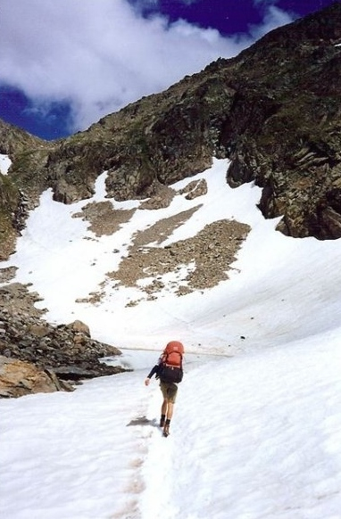
Ascending the Col de la Fache.
- Side Trip: Zugarramurdi – The Spanish Salem : Although to not the same degree as the GR10 and GR11, the HRP also passes through (or close by) some interesting mountain villages throughout its length. This was one of my favourite parts of hiking the HRP in 1999. If I had to pick just one side trip to recommend on the HRP, it might well be the short detour to the village of Zugarramurdi (population 225). Accessed via a seven kilometer (4.2 mi) side trip from the Col de Nablarlatz (Stage 2 in Cicerone Guide), Zugarramurdi is a picturesque Basque village in Spain known for being the setting of witchcraft accusations in 1609/10. According to legend, much of the occult activity took place in local caves, and irrespective of the veracity of the claims, a number of Zugarramurdis’ residents were subsequently tried and burnt at the stake by the Spanish Inquisition. In more recent times the village has embraced its dark and tumultuous past in the form of the “Dia de la Bruja” (Day of the Witch) festival, which is celebrated around the time of the summer solstice each and every year.
Zuggaramurdi (Wikimedia.commons)
Overview
- Watery Trailheads: The Pyrenean Haute Route may well be – along with the GR10 and GR11 – the only long distance hike in the world where you can start with a dip in the ocean and finish with a swim in a sea.
- The Pyrenean Combo Deal: The Pyrenean Haute Route offers a unique fusion of natural, historical, culinary, libational and cultural features. My advice is to embrace all of these elements with equal gusto! When you wake up in the morning, greet the sun as an old friend and give thanks for all that you have. When you set up camp at day’s end be sure to catch the last rays of sunset, and once again take a moment to appreciate what a gift it is to be hiking in such a beautiful part of the world. When you are sitting down in the refuges for the occasional evening meal with other trekkers, eat and drink and laugh and share stories until the hut warden asks you to call it a night. And when you are passing through the centuries-old villages along the way, learn about their history, practice your French and Spanish with locals (no matter how dodgy your language skills may be), try as many of the local dishes and drinks that you can. Embrace the Pyrenees with all that you have, and by hike’s end, you may just find you have had an experience you will never forget.
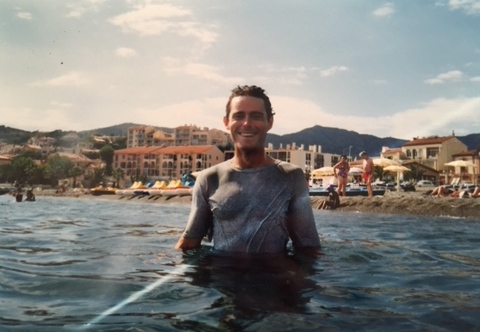
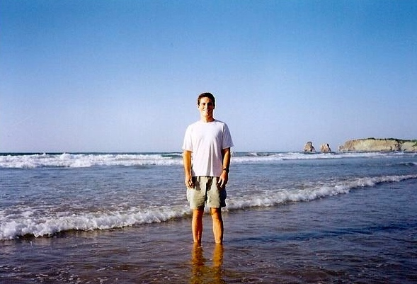
Yours truly taking a well-earned dip in the Mediterranean at the end of the HRP – hiking clothes and all! (Postscript: If I look a bit skinnier than usual – see the Atlantic ocean photo for comparison – it’s because the HRP was the one and only time in my hiking life that I have had giardia. I lost about 11 kg (24 lbs) during the last few weeks of the hike and ended the trip weighing 72 kg – the lightest I had been since I started high school!
Discover more from The Hiking Life
Subscribe to get the latest posts sent to your email.
Hi Cam,
Great article! Do you have an opinion on the Vargo Pocket Cleats V3 vs. something like the Kathoola Micro spikes? The Vargo ones weigh 69g (Titanium) to 87g (Steel) according to the manufacturers website: https://www.vargooutdoors.com/stainless-steel-v3-pocket-cleats.html
That makes them at least 230g lighter.
Also: How would you rate the “wind limit” of half pyramids like the Zpacks Hexamid or the MLD Cricket? I’m having a hard time finding information whether or not they are suitable for alpine, exposed and windy environments.
Cheers!
Hi Ray,
Thanks for the kind words.
Sorry, I’ve never used the Vargo Pocket cleats so I can’t really say. As for the Zpacks Hexamid and MLD Cricket, I’d probably rate the latter better for inclement weather when battened down in storm mode. That said, for exposed alpine conditions I would generally prefer a Mid over both of them for all-around protection.
Cheers,
Cam
Did you ever feel the steep rear and front panels of the Solomid were a problem in high winds? I realize the side panels should be positioned into the wind.
Just once. It was during the mother of all storms in Tassie’s Arthur Range. I was camped in a less than ideal spot, and although everything turned out ok, I remember the shelter took an absolute buffeting. When it comes to those sort of conditions, the Trailstar and Duomid would be better options – the former superior in high winds, the latter getting the nod in heavy snow. I actually just picked up a Duomid recently and plan to take it on an upcoming trip.
Cheers,
Cam
As always very thorough info Cam. A route that has “culinary and libational features ” to take the edge of all the climbing definitely has an attractive edge.
Hey Cam, thank you so much for the guide!
I am preparing for my HRP W to E thru-hike and was initially shooting for a start on august 20th, but now I want to push it back max. a week. I kinda already thought I was late in the season, but from some stuff I’ve read on HRP FB page september seems okay, even good for hiking the HRP. However I wanted to hear your thoughts on hiking it in september? I am planning to do it fast, trying to go for the 25 days or less 🙂 Also, I’ve heard there is a lot of snow in the mtns still, so waiting a bit more for it to melt could spare me having to carry spikes and iceaxe I am thinking.. Or would it be advisable to bring those still, in case of snow in september? Thank you very much! 🙂
During the summers of 1975 (Irun-salardú) and 1977 (Salardú-port Bou), a group of members of the Center Excursionista de Catalunya made the Pyrenean crossing, from modifications of the 1st edition (May 1975) d’haute randonnée pyrénéenne by Georges Veron •
I fully agree with the author that the Pyrenees is NOT a border, thus: “The Pyrenean Haute Route offers a unique fusion of natural, historical, culinary, libational and cultural features” despite the fact that Spanish and French nationalisms want the high route only pass in your country. Very narrow views
español inglés
Durante los veranos de 1975(Irun-salardú) i 1977(Salardú-port Bou), un grupo de socios del Centre Excursionista de Catalunya realizamos la travesia pirenaica, a partir de modificaciones de la 1ª edicion(may 1975) d’haute randonnée pyrénéenne de Georges Veron.•
Estoy completament de acuerdo con el autor que el pirineo NO es una frontera, así: “The Pyrenean Haute Route offers a unique fusion of natural, historical, culinary, libational and cultural features” a pesar que los nacionalismos español i francés quieren que la alta ruta solo pase en su país.M muy estrechas
During the summers of 1975 (Irun-salardú) and 1977 (Salardú-port Bou), a group of members of the Center Excursionista de Catalunya made the Pyrenean crossing, from modifications of the 1st edition (May 1975) d’haute randonnée pyrénéenne by Georges Veron •
I fully agree with the author that the Pyrenees is NOT a border, thus: “The Pyrenean Haute Route offers a unique fusion of natural, historical, culinary, libational and cultural features” despite the fact that Spanish and French nationalisms want the high route only pass in your country.M very narrow
I just found my next thru-hike!
Hi cam, great article.
I would like to ask you a specific question regarding finding gas on the GR10.
IS Camping Gaz CP250 available on the route? I have the adaptor for this which I use around the world.
Or is it mainly puncture type?
Or screw on types?
Any help would be greatly appreciated.
Kind regards Chris.
I Also hiked in 1999, but sadly E-W! So I didn’t get that wonderful warm med swim at the end. I was jealous of all the people summiting the high peaks in the middle at mountain huts. I hope you also heard the Montagnard Acapella choirs I heard on the French side. I sat outside a hall where they were performing. It’s the same in the Swiss Alps where it’s called volkslieder or berglieder…also Acapella & usually single sex. I cry even now as I think of it’s beauty. Weirdly, back then Andorra shops only had giant wheels of cheese & wine for sale tax free if I remember right or maybe that was 1992 on my 10,000 km cycle circle around Europe!… (don’t know where the locals shopped). At one low pass was hundreds of crosses left by Camino de Santiago hikers. I was trying to decide on buying a bunch of cookies or not in Spain so I opened it up to try it & they sure freaked out …but were happy when I paid for a bunch of them. Never did hike they snow, but almost got lost in one Star Wars looking bunch of hoodoo fingers….was so glad to reach the Refugio, even if they do serve fish with the head on! Bon courage mes amis!
Hi,I would be interested in the general availability of puncture versus screw for small stoves I have both types of stove and although the screw is a better(more modern) stove the gas tends to be expensive. In Andorra puncture is more available.I thought I may carry one of my old puncture stoves then leave it in the last refuge I visit (shall also prob carry my home-made leaf and twig burner.Regards…Gareth from Wales.