
Ascending to Ishinca Pass | Cordillera Blanca Traverse
Between August 21 and September 6, 2014, I completed a traverse of Peru’s Cordillera Blanca, one of the world’s highest and most beautiful mountain ranges. To the best of my knowledge, it was the first time that such a trek had been completed.
Beginning north of Nevado Alpamayo and finishing at Pastoruri Glacier, the route consisted of a combination of trails, cross country scrambles and the occasional stretch along backcountry dirt roads. Coming in at approximately 252 miles in length, it took in a multitude of turquoise lakes and went up and over 23 mountain passes ranging between 14 and 17,500 ft. A veritable alpine wonderland; that happens to be situated in the tropics.
For journal entries & photos of each of the traverse’s four stages, see the links below:
- CBT Stage 1 – Hualcallan to Pompey
- CBT Stage 2 – Pompey to Pitec
- CBT Stage 3 – Pitec to Chavin
- CBT Stage 4 – Chavin to Pastoruri Glacier
- Gear List: Cordillera Blanca Traverse

Cordillera Blanca Overview Map
At a Glance
Distance: Approximately 252 miles (406 km)
Start: Hualcallan
Finish: Pastoruri Glacier
Time: 16.5 days (including one rest day in Huaraz)
Difficulty: Challenging
Season:
I hiked the CBT in August/September, which is dry season in the Central Andes. Technically speaking it is also winter, however, the fact that the Cordillera Blanca is situated so close to the equator means that temperature fluctuations are relatively minor throughout the year.

Lago Culicocha
Maps / Info:
I used two topographic map sets during the CBT:
1. Alpenvereinskarte (German Alpine Club): Consists of two 1:100,000 maps which cover the entire range – 0/3a Cordillera Blanca Nord & the 0/3b Cordillera Blanca Sud.
2. Skyline Adventures: Also two maps split into north and south. Both are 1:75,000. The Skyline maps do not cover the most southern part of the Cordillera Blanca range.
- Altitude: Elevation for the CBT ranged between a low of 10,300 (village of Hualcallan; starting point) and a high of 17, 500 ft. Aside from the initial climb out of Hualcallan, the entire route pretty much stays above 12,000 ft.
- Resupply: The relative narrowness of the Cordillera Blanca range means that it is relatively easy to access. Villages and towns dot both the eastern and western sides of the mountains. A boon for solo long distance trekkers in regards to resupply options.
Route / Conditions:
- Character: As with most of my routes over the years, the CBT was not a “shortest distance from A to B / constant forward progress” type affair. I took a handful of side trips to hot springs, archeological sites and other points of interest along the way. Whenever possible, I chose the most scenic alternative available, regardless of whether or not it was shorter or longer than other options.
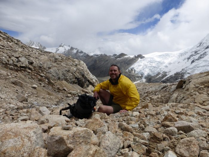
Big Bird/Yours truly on the ascent up to Ishinca Pass.
- Navigation: Despite the relative lack of detail in the aforementioned topo maps, in fine conditions navigation was not difficult during the CBT. Thanks to an abundance of distinctive landmarks, long U-shaped glacial valleys and lots of passes from which to spy the route ahead, it was not hard to keep track of one’s location.That being said, when afternoon thunderstorms roll in, the way is anything but clear and you are hiking through a sea of cloud at 15,000 ft plus, it pays to have your stuff together navigationally speaking. This particularly held true for the second and third stages of the CBT, which included more in the way of trailless, technical terrain.
- A Tale of Two Halves (almost): The first 40% of the hike from Hualcallan to Quebrada Honda took six days to complete. It was mostly on established trails. The last 60% of the trek, from Quebrada Honda to Pastoruri Glacier, was much slower going due to the large percentage of the route being cross country. Bushwhacking up and over 16,000 ft passes ain’t easy!

Puya Raimondii | Laguna Gueshguecocha | Cordillera Blanca Traverse

Pastoruri Glacier | Finishing Point of the CBT | Peru, 2014
Cordillera Blanca – General miscellanea
- Situated in the Ancash region of Peru, the Cordillera Blanca is a sub-range of the Andes mountains. It is approximately 13 miles wide (21 km) and 124 miles (200 km) long as the crow flies. It’s like the “Chile” of mountain ranges; long and very narrow.
- It sports a dozen peaks that are higher than 20,000 ft (6096 m), with a further twenty-four topping 18,000 ft (5486 m).
- It is estimated that there are 260 glaciers within the Cordillera Blanca range. The largest concentration of tropical-zone glaciers on the planet. Since the 1970’s they have retreated more than 15%. A staggering reduction; especially considering their hydrological importance to a growing Peruvian population.
- In 1970, the Cordillera Blanca was rocked by an earthquake (7.9 on the Richter scale) that wiped out 95% of Huaraz (the regional capital), completely destroyed the town of Yungay and was responsible for the deaths of up to 70,000 people. It was the worst natural disaster that Peru has ever had, and the resulting avalanche that caused much of the destruction is thought to have been the deadliest in world history.
- Famous Peaks: Legend has it that Artesonraju (6025 m/19,767 ft), is the inspiration behind the famous Paramount Pictures icon. A few miles north of there lies Nevado Alpamayo, a stunning pyramid-shaped peak (see photo above) that was voted the world’s most beautiful mountain by an international survey commissioned by the German Alpine Club back in the 1960’s.
- Chavin de Huantar: World Heritage listed archeological site situated on the eastern flanks of the range. Dating back more than 3000 years, Chavin de Huantar was the religious centre of the Chavin people, one of the major pre-Inca cultures of Peru. Very cool place. I visited there in 1996 and again in 2014 (see photo below).

Llama at Chavin de Huantar | Cordillera Blanca Traverse | Peru, 2014
Discover more from The Hiking Life
Subscribe to get the latest posts to your email.
Wow!!! Cam…spectacular…cant wait to hear more….such magnificent country!!!
Thanks, Laura. Hope all is well in CA!
Cam,
Thanks for all the effort you put into your most informative blog. I’m planning a trip to the Cordillera Blanca and Huay Huash this August and was wondering if I could ask you a few questions about appropriate shelters. I’m planning to bring a two person pyramid and was wondering about your thoughts on this. I see you used a tarptent. Also should I bring a mesh inner or would a bivy be more appropriate? How cold and wet does it get in the upper regions and how bad are bugs in the valleys?
Hi Gen,
Thanks for the kind words.
A Mid-style shelter would be a great choice for the the Cordillera Blanca & Huayhuash.
In regards to the inner Vs bivy question, I don’t think it makes a big difference. Bugs aren’t an issue and it would be unusual during the “dry” season to be stuck inside your tent for any great length of time.
As for the temps, it often drops down below freezing at night and occasionally during the day as well. In my experience, rarely would it go much lower than -10°celsius.
Have a great trip!
Cheers,
Cam
Cam,
Thanks for the quick response.
Hope you don’t mind if I ask a few more questions.
I’m an avid flyfisherman and was wondering how the fishing was in some of the lakes and streams. I’ve read it was pretty decent in the past but there is very little info on conditions now. Would you happen to know? Would love to supplement my diet with fresh protein.
Regards,
Gen
Hi Gen,
Sorry, can’t help you on that front. Though a quick google search came up with this article from the Huaraz Telegraph: http://www.thehuaraztelegraph.com/2014/09/high-altitude-trout-fishing/
Cheers,
Cam
Thanks for the link Cam. Yeah I came across that before. Hopeful but a little sparse on info.
I see you used a Katabatic Sawatch 15°F quilt on your CB traverse. I’m thinking of using a Flex 30 + UL down jacket & pants + down hat. What do you think? Am I pushing it? I tend to sleep hot and I hear Katabatic temp ratings are conservative. How did you find the Sawatch? Too much or just right?
Regards,
Gen
Hey Gen,
Depending on the warmth of the jacket and pants, as well as your other layers, you could be ok.
You are right about Katabatic quilts being conservatively rated. In hindsight, I probably could have got away with taking my Palisade 30 (note: I’m an average sleeper), but in the end I was glad I took the Sawatch. There were a few chilly nights when I camped just below the passes at around 15,500-16,000 ft. The extra 5 or 6 oz were worth it just for those occasions.
Cheers,
Cam
Hi Cam,
Been a huge fan of your site for a few years now. Do you remember Nancy Huber by any chance? She’s hiked with you for a while on either PCT, CDT or AT (can’t remember which) and she spoke incredibly highly of you. I’ve known her since I was a kid, she was the co-owner of my aunt’s dental practice.
Anyways, over the last few summers I’ve become addicted to high routes (SHR, SoSHR, WRHR). The 200ish mile range is perfect for me right now, plus after tasting off-trail orienteering, cross-country walking and class 2-3 scrambling, I can’t go back.
I’ve got about 4 weeks off in June 2017. After doing high routes in the Sierras and in the Rockies, I’m feeling ready to try one in another country. The Cordillera Blanca looks absolutely irresistible. Plus Andes are second highest mountain range in world after Himalayas and its various offshoots…
One question I’ve been thinking about — did you try to come up with any off-trail options that would break up the long 90 mile stretch of on-trail in the first half of the trip? Are all of the passes through that area too serious? When you were deciding the off-trail passes to do in the second half, how did you go about making sure that they would be safe — i.e., that you wouldn’t need full-on mountaineering gear?
Anyways, thanks so much for the incredible write-up!! It’s super inspiring. Thanks for sharing 🙂
Hi Austin,
Thanks for the message. Yes, I know Nancy quite well. We first met on the Olympic Peninsula in 2011……a great lady! In regards to the Cordillera Blanca, I didn’t look into off-trail Pass options for the first section. For the subsequent stretches, I used a combination of Google Earth, the topo maps available and best guesstimates. There ended up being two passes in which microspikes were very handy and in hindsight an ice axe would also have been useful.
Cheers,
Cam
Heyhey:) awesome trek:) im planning on doin my own cbt starting in about two or three weeks based on your route ( well more what I think could have been your route?) which passes where the most difficult in your opinion and if you were to do it again would you take mikrospikes or should I be fine without? Thanks for your help:) heading to the huayhuash now?
Hi Kathrin,
I think there’s enough info in the respective stage posts that experienced folks with the topo maps can figure out the route more or less. The toughest passes were probably the ones I called Cashan and Ishinca. Whether or not you’ll need spikes and an ice axe for the middle stages (not necessary for the first and last stage) depends on the current snow levels. If I was you I’d ask around in Huaraz for up-to-date info.
All the best on your hikes.
Cheers,
Cam
Hey Cam!
Love the writeup and the stage posts.
If you were going to spend a week photographing/hiking through one of the 4 sections, which would it be?? Any one area more scenic than the rest?
Hi Eric,
Thanks for the kind words.
Parts of the second and third stage are probably the most scenically impressive, but they are also the most challenging and technically difficult. The whole trek is quite spectacular, so whichever stage you choose I’m sure there will be lots of great photo opportunities.
Cheers,
Cam
Hi Cam.
Just wondering what your thoughts where on trecking in this region during mid October/November. Optimistic online info is sparse.
I only have experience with conditions in Nz, with its lower elevation.
Outside of the June to September window isn’t ideal for the Blanca. You could still do it, but it would likely mean shorter days and more time riding out dodgy weather in your tent.
Heyhey:) with some delay ( got lost in the endless possibilities of this beautiful area?) i finally did my Cbt and finished yesterday after 22 days including two rest days( because if some knee problems) in huaraz. Did some minor changes Regarding the trail and the resupplying but for the most part followed your route. It was absolutely amazing and everything worked out fine. Big massive thank you for the inspiration and providing all the information to make this hike possible!!! It’s highly unlikely that I would have gotten this idea myself and even if so I probably would not have dared to go for it?THANK YOU!!!
Hola:) with a bit of delay due to the infinite possibilities huaraz area has to offer I finished my CBT about a week ago:))) it was amazing and everything worked out fine… massive THANK YOU for the idea and inspiration as well as for providing all the information!!!… without your blog it’s unlikely that I ever would have gotten this idea and even more unlikely that I’d dared to go for it;) saludos kathrin
Congrats on your hike and thank you for the kind words. The Cordillera Blanca really is an incredible range, and there is so much more to it than the Santa Cruz and Alpamayo treks that most folks do.
Cheers
Cam
Hi Cam,
please, is there reason why you went SOBO? Would there be difference or would it be harder or some passes not possible if i would go from south to north?
As I am planing to do Huayahuash before, I am thinking, that I will be closer to southern end. And also I did Alpamayo trek in 2009, so that could be the last one…
Thanks a lot
Hi Michal,
Thank you for the message. There was no particular reason why I decided to do the route north to south; I think it would be just as feasible going in the other direction.
All the best,
Cam