Located in northeastern Italy, the Dolomites are one of Europe’s most dramatic mountain ranges. A combination of serrated limestone peaks, sheer cliffs, shimmering alpine lakes and deep, narrow valleys, they have long been a magnet for geologists, travellers and outdoor enthusiasts alike. From a hiker’s perspective, this legendary sub-range of the Alps boasts an extensive system of pathways (i.e. “Vias”), and of the many trails that crisscross its rugged topography, the most famous of them all is the Alta Via 1 (AV1).
I hiked the AV1 along with the Alta Via 2 over 10 days in mid/late September, 2019. Click here for a full rundown of the latter hike. Please note that the information below is largely directed towards independent hikers, rather than folks going as part of organised trekking groups.

Ascending towards the Forcella de Zita Sud on Stage 10 of the Alta Via 1.
At a Glance
Distance (11 Stages): 120 km (75 mi)
Duration (average): 8 to 10 days
Difficulty Level: Moderate
Start / Finish:
- Lago di Braies
- La Pissa Bus Stop (Val Cordevole)

Lago di Braies – Northern terminus of the Alta Via 1

Lago di Braies – the rowboat capital of the Dolomites.
Which Direction?: I don’t think it makes much of a difference, though the majority of people seem to hike north to south; which is the way the route is described in the Cicerone guidebook listed below.
Elevation Gain: 6,665 m (21,833ft) approx.
Highest Point: Rifugio Lagazuoi – 2,752m (9,029ft)
Lowest Point: La Pissa – 448m (1,470ft)
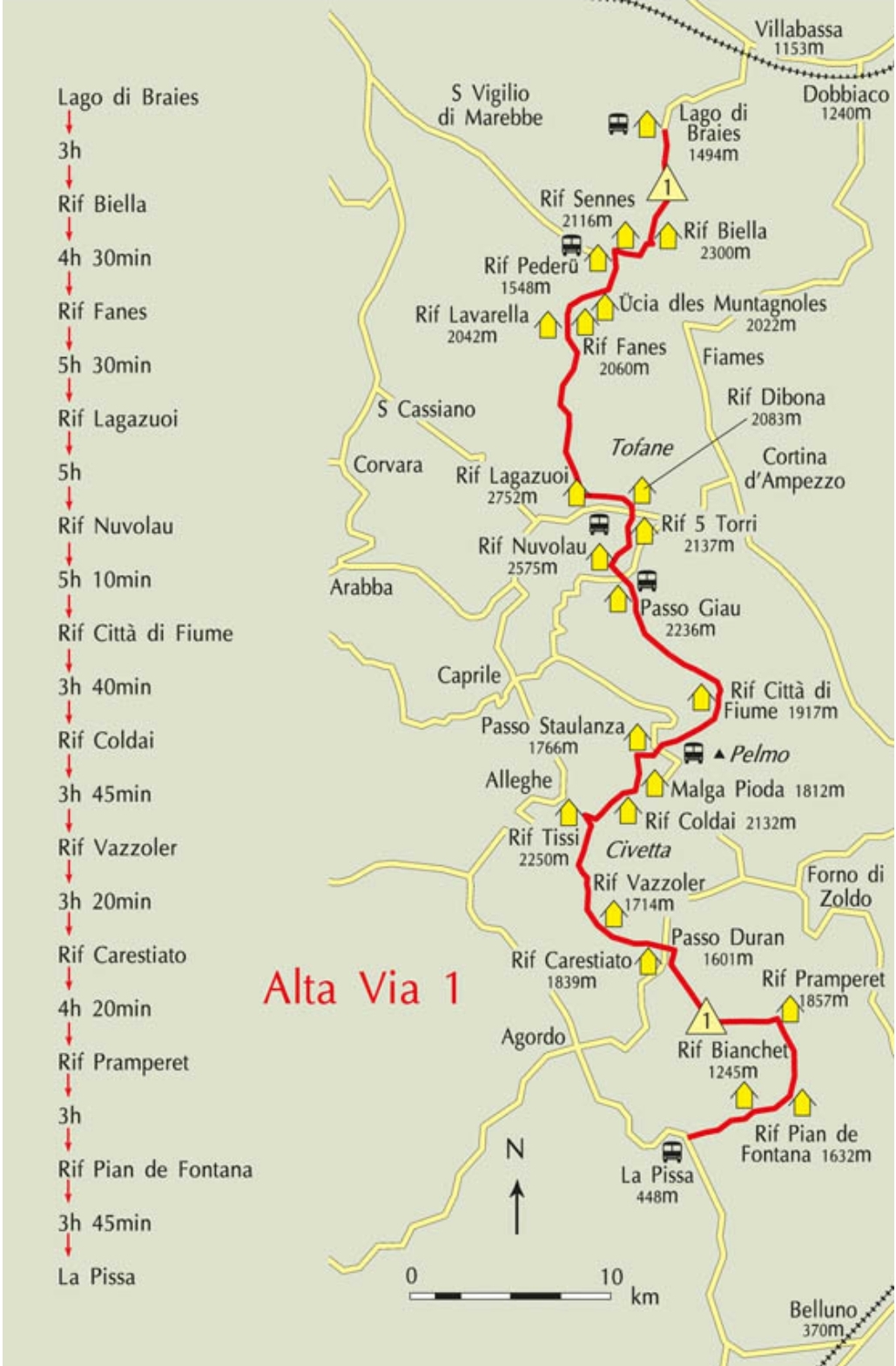
Alta Via 1 Overview Map (Trekking in the Dolomites, Cicerone Guides)
Getting There & Away
- Lago di Braeis is serviced by regular Dolomiti buses to and from the villages of Villabassa and Dobbiaco. They leave hourly during the summer months and take between 20 to 30 minutes to reach the lake. See the Dolomiti website for the current schedule. Both Villabassa and Dobbiaco are accessible by train.
- La Pissa Bus Stop (Val Cordevole) is 20 minutes from the town of Belluno. For current timetables see the Dolomiti website. Note that timetables are also displayed in the last couple of refuges on the trail. From Belluno, onward bus and train services are available.

Southern terminus of the Alta Via 1 in the Val Cordevole.
Season
- Mid-June to late September. In an average weather year, September is ideal. The school holiday crowds are gone, the summer thunderstorms (generally short) have subsided, temperatures are cooler, and the mountain huts are less crowded (Tip: During July and August storms most often occur during the afternoon. If possible, try to make early starts and get the lion’s share of your hiking done in the morning hours).
- Depending on the snow levels and experience of the aspirant, the AV1 can also be done in the late spring or early to mid fall. When hiking at these times, you may require an ice axe and traction devices. Also note that most, if not all of the huts will be closed, so you will need to carry all of your own food and a tent/tarp.

Yours truly approaching the Forcella del Lago (2,486 m) on Stage 3 of the Alta Via 1.
Planning Information
- Guidebook: Gillian Price, Trekking in the Dolomites (Cicerone Guides) | Kindle version available | The book includes logistical beta, trekking notes, elevation profiles, basic maps (not detailed enough for navigation), town information, and time and distance estimates for each of the AV1’s 11 stages.
- Maps: 1. Tabacco produces the most detailed hiking maps for the Dolomites. Three 1:25,000 topo maps cover the entire AV1 (i.e. Sheets – 031, 03 and 025, ). Also available online from Amazon and Omnimap.com. Note that it is possible to pick them up once you arrive, but there are no guarantees all three sheets will be available; 2. Alternatively, Kompass produces a 1:50,000 ‘Wanderkarte’ series that covers the route (3 maps total – Sheets 57,55 and 77).
- GPS Data: Alta Via Dolomiti 1 (Traildino.com), Altavia delle Dolomiti 1 (Wandermap.net)

Stage 5 between Rifugio Nuvolau to Rifugio Citta di Fiume passes through a gorgeous high altitude pasture which was once the domain of Mesolithic hunters.
- Permits: No permits are required to hike the AV1.
- Language: German and Italian. A basic knowledge of either definitely comes in handy, however, almost all of the locals you’ll encounter along the route know at least a little English.
- Cell/Mobile Phone Coverage: I tend to keep my phone in flight mode 99% of the time while I hike, but from what I can tell service in the Dolomites is spotty once you leave the villages/towns. That said, on the AV1 most of the huts now offer Wifi for guests, and it is usually possible to charge your phone and/or battery pack whether you are overnighting, or just stopping in for breakfast or lunch.

Skirting below the Cime de la Scala on the final stage of the AV1.
- Cash or Card: Many of the huts (though not all) along the AV1 accept credit cards. Be sure to bring enough cash just in case you are staying in one or two that don’t.
- AV1 Planning Summary: I’d recommend the following course: 1. Read through this article; 2. Purchase the informative Cicerone guide; 3. Download a GPX file (see above) to your phone (I use the Gaia GPS app), and; 4. Pick up the Tabacco maps.
Resupply & Water
- Resupply: You won’t go hungry on the AV1. Procuring food along the way is simple if you are hiking during the summer season. Simply eat your main meals at the regularly-spaced Rifugi (mountain huts), at which you can also purchase snacks and sandwiches to go. Note that if you are interested in hiking out of season, you either have to carry all your own food from start to finish, or undertake some detours off-route along the way.

Refugio Biella at the end of Stage 1.
- Water: Unlike in many other parts of the Alps, H20 is relatively scarce in the upper regions of the Dolomites. According to Gillian Price in the Cicerone Guide, this is due to the “dolomite-limestone rock (most surface water disappears underground) as well as the dearth of glaciers and permanent snow fields.” In practical terms, this means that hikers should always be aware of where their next chance to fill up will be before setting out on each stage. Note that bottled water is always available for purchase in the huts – generally at very expensive prices (e.g. €3 for a 1.5 lt bottle – September, 2019).
Route / Conditions
- Overview: Although quite demanding in sections – there is a total of 6665 m (21,833 ft) elevation gain throughout its course – the AV1 is well marked and maintained, and within the capabilities of most hikers. An excellent multi-day option for first-time alpine hikers. Unlike the region’s famous Via Ferratas (i.e. “Iron Roads” – protected climbing paths with cables, ladders and iron rungs that are attached to rock walls), the AV1 doesn’t include any technical sections that require specialized gear. That being said, for those wishing to experience the famed iron roads, it does pass by some of these spectacular alternates; notably the Ferrata Marmol on Stage 11.
- History: The Via Ferrata are much more than an exhilarating way to experience the Dolomites breathtaking landscapes. They also represent a visual reminder of the area’s bloody history. During WW1, the Dolomites were the scene of fierce battles between the Italian and Austro Hungarian forces. The Via Ferrata were installed during these years as a means of enabling troops quicker access to the front line. The Alta Via 1 also weaves through fascinating open air war museums at Mount Lagazuoi (the Alta Via 1’s highest point) and Cinque Torri (Five Towers). At these scenic locations, hikers can witness first hand the extensive system of tunnels and trenches that were built between 1915 and 1917. The juxtaposition between somber history and spectacular natural beauty is striking.

The beginning of the Stage 4 alternate via the steep tunnel (see below for details) just below Rifugio Lagazuoi

During World War 1 troops on both sides excavated a system of tunnels around the Piccolo Lagazuoi for the purpose of laying explosives to mine enemy positions. The most notable of these tunnels is the Galleria Lagazuoi, which descends for 1100 m at a 45° gradient for a total elevation drop of 230 m (Note: Don’t forget your headlamp).
- Navigation: The trail is well marked from start to finish. The route is marked with red and whites paint splashes and cairns.
- How Long will it take?: In the opening “At a Glance” section I mention that the average AV1 hiker will take between 8 and 10 days. That said, the amount of time it takes to finish the AV1 can vary greatly depending on a number of factors. Fit and experienced hikers carrying a light pack, can comfortably do the AV1 in four or five days.
- Favourite Sections: My favourite stages on the AV1 were as follows:
-
- Stage 4 Variant – Rifugio Lagazuoi to Rifugio Nuvolau. Unless you have severe claustrophobia or dodgy knees, be sure to take the variant via the wartime tunnels down to Passo Falzarego.
- Stage 5 – Rifugio Nuvolau to Rifugio Citta di Fiume – High altitude pasture with stunning rock formations.
- Stage 10 – Rifugio Pramperet to Rifugio Pian de Fontana. Arguably the best views of the whole trail on either side of the Forcella de Zita Sud.

Approaching the Forcella de Zita Sud (2,395 m / 7,858 ft)
Sleeping
Options on the AV1 include staffed mountain huts and wild camping:
- Mountain Huts: The majority of backpackers in the Dolomites stay in the rifugi (mountain huts). These staffed refuges can be found throughout the range, and often boast incredible high altitude locations, along with spectacular vistas. Most are open from mid-June to late September, and along with overnight accommodation (dormitory and sometimes private rooms), they also offer breakfast, lunch and dinner. The best value can usually be found in the half-board offer (mezza pensione), which consists of a three course dinner, a bed, and breakfast. As of 2019, half-board costs around 45 to 55 Euros. Note that members of the Club Alpino Italiano usually pay around 20% less than non-members, and folks that are affiliated with certain other European Alpine or Mountain clubs (e.g. UK, Austria, German, French), enjoy reciprocal rights. During the peak season months of July and August, accommodation should ideally be booked in advance (especially if you are hiking in a group).

The beautifully situated Rifugio Pramperet marks the end of Stage 9.
- Wild Camping: Regular readers of ‘The Hiking Life’ knew this bit was coming. While I enjoyed eating breakfasts and lunches in the huts during my time on the AV1, I avoided overnight stays in the huts. The main reasons for this is were that: A. I don’t sleep well in dormitories, and; B. If I’m hiking in the mountains I prefer to sleep outside whenever possible. That being the case, I did what I almost always do – set up camp at sunset and left the following morning before sunrise.
- Is Wild Camping Legal in the Dolomites?: Officially speaking, “camping” – which is apparently defined in Italy as staying in the same tent site for more than 48 hours – is strictly prohibited. On the other hand, the “overnight bivouac” – setting up late and leaving early the following morning is allowed (or at least tolerated) as long as you practice LNT principles. See the following article on the hikedolomites.com website for a more detailed breakdown.
- Practically speaking, I found wild camping in the Dolomites to be similar to other Alpine regions I have hiked through over the years – that is, as long as you set up late in a stealthy spot, leave at dawn the next day, and practice LNT principles at all times, there are no issues. During my trip I met a handful of other campers who like myself encountered no problems following this strategy.

Drinking in the alpenglow from a wild camp on the Alta Via 1.
Final Thoughts on the AV1
1. Alta Via 1 Vs Alta Via 2 – I hiked these two beautiful trails back-to-back over 10 days in mid/late September, 2019. I was very fortunate with the weather, encountering only one day of rain during both hikes. A few points to note:
- The Alta Via 1 is easier and more frequently trafficked than the AV2, being particularly popular with organised trekking groups. Something to keep in mind if you are making hut reservations in advance.
- Unlike the Alta Via 2, there are no Via Ferrata sections on the standard AV1. This fact, along with is generally gentler elevation profile and easier terrain, makes it the option of choice for folks that are relatively new to multi-day hiking trips.
- Which is more scenically impressive – the AV1 or AV2?: That’s a tough one. It is very close, but if I had to choose I’d probably go with the AV2. On the other hand, I’d give the AV1 the advantage on the history front, and probably a slight edge in regards to culinary options as well.

I never actually weighed myself, but I suspect I may have put on a kilo or two during my time in the Dolomites (lunch at Rifugio Coldai).
2. Enrosadira – The rock pinnacles and spires of the Dolomites are particularly spectacular at sunrise and sunset, as the pale dolostone peaks light up with a salmon-coloured glow. The Italians refer to this phenomena as “enrosadira” (alpenglow).
3. Base for the Dolomites: During my time in the Dolomite region, I based myself in the town of Brunico (Bolzano), which not only provided easy access to both the AV1 and AV2, but also to the third multi-day hike I did in the area, the Pfunderer Hohenweg (trip report still to come).
4. Carry a light pack – There are a number of reasons to lighten your pack load, however the big ones are simply comfort, health and enjoyment. It is better for both your body, which is less likely to incur stress-related injuries, and also your mind, which is likely to be less distracted than it would be under the burden of a heavy load (see the Gear and Ultralight dropdown menus for tips). Thanks to the regularly situated full-service huts on the AV1, hikers never have to carry more than a few snacks, and for those staying exclusively in huts, your pack will be even lighter still as there is no need to pack a shelter or even a sleeping bag/quilt. For a rundown of the gear I carried on the AV1, see the accompanying post: Gear List: Alta Via 1 and 2 (Dolomites, Italy).
5. Timing Your Days: As is the case pretty much all over the Alps, most of the hikers you will encounter seem to begin their hiking day around 8 – 9 am, and finish sometime between 2 and 4 pm, when they arrive at their pre-reserved hut. This means that the trails are often hiker-free during what I consider to be the best times of the day (i.e. early morning and late afternoon). From my perspective, herein lies the greatest benefit of carrying your own shelter – freedom. The freedom to arise at dawn when the birds are singing, and walk in solitude under an infinite ceiling of emerging blue. The same applies to sunset, when the temps are cooler, wildlife reemerging and the sky is turning fifty shades of crimson. These are the times when I most want to be out on the trail. Not necessarily to cover more miles, but instead because it makes me feel like I’m more a part of the daily miracle that is unfolding all around me.
6. My AV1 Strategy: FWIW, here’s a rough breakdown of my daily schedule during my 3.5 days on the AV1:
- Start my hiking day at dawn.
- Usually, I’d be camped 30 min to an hour from the next hut, which I’d aim at reaching by 730/8 am at the latest for a morning meal.
- Breakfasts – In general, brekky at the huts was a mixed bag. The good ones included a buffet of cereals, bread, cheeses, meats, multiple cups of coffee, and cost around €9 or €10. The not-so-great ones were of the continental variety consisting of bread, butter, jam, a coffee, and that’s about it. These cost €7 or €8 and I invariably left hungry………not really, as in these cases I’d buy something extra to go.
- Lunches – Upon leaving after breakfast I knew more or less how long it would take me to get to the next hut, where I would stop for a midday/mid-afternoon meal. As long as I got there by 2 to 230 pm, I always knew they’d still be serving. Lunches at the Rifugi were sometimes pricey, but always good, with hot meals setting you back anywhere between €10 and €16. I usually added a dessert and a couple of beers, after which I waddled out €20 to €30 lighter in pocket (but content of stomach).
- Dinner – I’d often leave my lunch stop with one or two sandwiches (and an overpriced chocolate bar) to tide me over for the rest of the day. Looking at my maps, I’d have in my mind the areas where I could most likely find a nice camping spot, at which point I’d generally arrive around sunset. The next day I’d wake up and do it all over again………..

Stage 10 – Final sunset of the AV1.
Related Posts
Disclosure: This post contains some affiliate links, which means ‘The Hiking Life’ receives a small commission if you purchase an item after clicking on one of the links. This comes at no additional cost to the reader and helps to support the website in its continuing goal to create quality content for backpackers and hikers.
Discover more from The Hiking Life
Subscribe to get the latest posts sent to your email.
Love your sense of humour. Forwarded your 60 presents for hikers to a few friends for present ideas for me. Hahahaha.
Thank you
Ursula
Thanks for another very efficient write up Cam. Me & a mate are planning to spend a couple of weeks in the Dolomites in 2021. The Alta Via 1 & 2 look just the place. Hopefully we can snag as good a weather window as you got!!
Many thanks,
Peter
Thanks for the kind words. Have a great time in the Dollies and best of luck on the meteorological front. That said, if an afternoon storm does roll in, kicking back with an extra beer or two at one of the refugios is not such a bad way to wait it out!
Cheers,
Cam
Hi Cam, what can u say about exit points from VIA1?
In case we want to make only 4-6 days hike is there an option to exit and how can we get back to the starting point where we plan to leave our car?
thanks
Igor
Hi Igor,
The attached map from the Cicerone guide (which I’d recommend purchasing) shows the different places where you can catch the bus along the AV1. Once you decide on the point at which you’d like to get off the trail, check out the Dolomiti website for local bus times.
Best of luck.
Cam
Thanks , this is a very informative article. We are thinking about our next hike adventure and your insights are very helpful.
Cam,
Thanks for any information. Your books and website are a source of inspiration. I also plan to run the AV 1 and AV2 this summer.
It seems logical to me to walk the AV1 from south to north and the AV2 from north to south. I was wondering if you did this too?
If so, was the connection between Lagi d Braies and Bressanone doable?
Thanks
Hi Rene,
Thanks for the kind words. In regard to your question, I hiked both trails from north to south. During my time in the Dolomites I based myself in the small town of Brunico, so in between hikes I returned there to have a shower, wash clothes, and pick up my supplies (which I had in storage at the hotel) before leaving for the next trail.
That said, it would not be difficult to connect between Lagi d Braies and Bressanone. Simply get one of the regular buses from the lake down to Villabassa and from there take a train to Bressanone (via Fortezza where you will need to change).
Best of luck with your trip!
Cheers,
Cam
Cam, Thanks for the lightning fast answer. I think I’m going to follow the expert’s system; both north from south. Just not at your pace.
Let’s hope Italy doesn’t get a new lockdown.
Hi – I’m hoping to do it in 5 days max, could you share the stages you did it in to give me an idea of what is achievable and good areas to end/start the day from. I presume you were doing 8+ hour days on trail? Cheers J
Hey Josh,
I tend to avoid giving locations for wild camping, but there are plenty of options for discreet overnight bivouacs. Just be on the lookout for a place to set up an hour or so before it gets dark.
As for my time on trail, yes, it would have been 8+ hours a day. Not sure of the exact amounts, but as I mentioned in the article, I started early, finished late, and on both the AV1 and AV2, enjoyed long breaks at the Refugios for both breakfast and lunch.
All the best on your trip.
Cheers,
Cam
Great write up – thank you – a real help for the trip we are planning.
I’m struggling to identify the timetable for the bus from La Pissa to Belluno on the Dolomiti website (or anywhere else) – would you know the number of the bus line, or failing that the name of the terminus the bus will be coming from please?
Many thanks
David
Hi David,
Thanks for the kind words. Here’s a link to the Rome2Rio website which may prove helpful.
Cheers,
Cam
For timetables of busses I found this website helpful: https://www.sii.bz.it/en?deviceType=desktop
Would you be willing to share your secrets about some good camping spots? For me sleeping in fresh air is always essential for enjoying the mountains. I’m off in 3 weeks and the perspective of huts already disgusts me.
Hi Maria,
Thanks for the message.
To avoid overuse issues, I prefer not to share specific details about wild camping spots. On the AV1 and AV2 you shouldn’t have too many issues finding discreet places to set up; just give yourself plenty of time at day’s end.
All the best on your trip.
Cheers,
Cam
Understood! Thanks, Cam.
Any recommendations on the best 5-6 days trek with teenagers? We did 5 days on the Haute Route (averaging about 10 miles and 3,000′ of elevation a day), stayed in the huts, and skipped some sections with the help of busses and trains. I’m looking for something similar in the Dolomites in the next year or two. I am just starting my research and this website is great.
Hi Steve,
Thanks for the kind words about the site. The Alta Via 1 is transport friendly, but there are a lot of other possibilities in the Dolomites that would also suit your needs. I’d suggest picking up the Cicerone guide, which gives a good overview of all the Alta Via options on offer.
Cheers,
Cam
Many thanks. Covid delayed me a year, but trying to get this on the calendar for 2022. Just bought the Cicerone guide!
Hi Cam, thanks for the summary of the Alta Via 1 trail. We did the trail in 7 days in a group of three end of this Sep / early Oct and it was just perfect – edge of seasons, we experienced summer, autumn and winter during the course of a single week. Surprising amounts of snow even for the locals however it melted down quickly. We stayed in the (few) refugios that remained open, sometimes staying overnight during the last day they were still operating. The trail was far from being crowded at the end of the season, apparently also due to the COVID situation. Met a few crazy folks doing Venice – Munich long distance trail – still remember one guy with 28kg backpack out of which was 8 kg a complete prosciutto leg :-). The trail is stunning and the food at the huts delicious – proper south Tyrol Italian way… the only downside were the areas close to roads in mountain passes with souvenir stalls etc. And the beautiful Lago di Braies… well, really nice place, but the crowds even during a rainy October day ;-(… anyway, really great trail quite close to my homeland and thanks for the inspiration!
Hi Tomas,
No worries at all. Glad you had a great time!
Cheers,
Cam
Edit: I just had a look at some of the hikes on your website. Your photos are fantastic!
Hi Cam,
I plan to travel by campervan so wish to park near Villabassa complete Alta Via 1 and then catch a bus/train combo from Belluno back to Villabassa to get back to my campervan. Can you recommend a website to check the routing for this, please?
Also are there bus transports along the route so that I can break the trip and head back to Villabassa if I wish after a few days?
Thanks,
James
Try Rome to Rio and Dolomiti Bus
Hi Cam! I’ve been reading your blog posts since I was 16 (twelve years now), and I just realized we were on the Alta Via 1 at the same time! Perhaps not a huge coincidence to you but this has me grinning from ear to ear! Happy hiking, maybe run into you one day 🙂
Zoë
Hey Zoë,
Thank you for the long-time interest in the website! That’s cool that we were both on the AV1 at the same time. Mid/late September was a great time to be hiking in the Dolomites. Over the years it never ceases to amaze me what a small world the hiking community is!
All the best,
Cam
Hi Cam,
I am 62 and plan to hike Alta Via 1 solo in mid August, 2021. I never backpack alone, but thought this would be safe. Am I right, is it safe for a solo woman of 62? I plan to stay in rifugios every night.
Carla
Hi Carla,
The Alta Via 1 would be an ideal option for your first solo backpacking trip. Have a great time!
Cheers,
Cam
Hi Cam, this is such a fantastic write-up, I’m getting super psyched for my trip in September 2021.
I read in the comments that you were hiking 8+ hours a day. Could you speak to the pacing that the Cicerone guide lays out for each stage? I’m wondering how conservative their hourly estimates are, as laid out in the map you shared at the beginning of the post.
Hi Kara,
Thanks for the message. Overall, I think the Cicerone estimates are fairly indicative of the time needed for reasonably fit and experienced backpackers.
All the best on your trip!
Cheers,
Cam
Hi Cam,
Amazing write up – this already helped so much. I’m not sure if you will see this in time – but I planned a last minute hike of the Alta Via 1. I’m headed out in 7 days and was wondering if you think it would be possible to use a discreet hammock set up in stead of a tent? Photos and videos I’ve been looking up seem to show plenty of trees, but its hard to know unless you have seen them in person. Thanks in advance!
Hi Cam,
Thanks for the great write up! Already helped a ton… I was wondering if you think hammock camping is a possibility? From photos and videos it seems that there are plenty of trees, but it is hard to know without seeing the trek in person. Thanks in advance for your help..
I suspect it would be possible, but your stealth options would definitely be more limited than with a ground-dwelling setup.
Cheers,
Cam
Hi Cam,
Thanks for writing such a useful guide! We are planning a last minute trip at the end of September and wondering if you have to book the Rifugios in advance or is it ok to just show up?
Many thanks
Pippa
Hi Pippa,
You may want to check whether the rifugios you are interested in will be open during your hike. All the best.
Cam
Hey Cam,
Great post and insights! Within the AV1, would you recommend the north or south half for epic views? Trying to figure out a plan for summer 2022 but only have a few days to get away. Thanks!
Hey Shivan,
That’s a tough one. Both halves contain some stunning scenery, and there really is very little to split them. If I had to choose, perhaps I’d go with the southern section.
Cheers,
Cam
A definate contendor for Summer ’22, thanks for the overview, some useful tips in there. I still find it hard to believe you can do all this and not take any food, perfect to keep the weight down. It’s On my shortlist
Yeah its true. I took food with me when I went in September, as well as a stove, tent, etc and realized none of it even got touched. The most I would suggest is a sleeping pad, 40-50* sleeping bag, and ultralight shelter for just in case situations. The food aspect though, there is food available everywhere, and it is amazing. They even make you lunch, water and snacks if you let them know at dinner time.
This may seem an odd question, but do the buses take credit cards?
Unfortunately it appears all of the rifugios are booked for my desired timeline. I’ve read in several places that rifugios won’t turn you away even if they are technically “full” – assuming this may differ depending on the rifugio but can you confirm if this is the case?
Thanks to you for providing all of this very helpful information!
My wife and I will be on AV1 in late July but, unfortunately, we won’t have an adequate amount of time to hike the entirety of it and still call it a vacation. We’ll have a total of six days in the Dolomites, and we’re trying to balance our (not always shared) interests in trekking, via ferrata, trail running, water color painting, and taking in the geology and history of the place. So we’re thinking we won’t want to take on more than about 50-60% of the entire distance.
Looking back on your trip, and considering what we’re trying to accomplish, what 40-ish mile length of the AV1 do you consider to be the most rewarding? And would access logistics (cable cars/road crossings/transit) be reasonable for starting and ending the trek at those spots? Thanks in advance for any feedback you can provide.
Hi Travis,
Thanks for your message.
As mentioned in the post, my personal favourite stages were 4, 5, and 10. Regarding a specific 40-mile stretch, as you allude to, a lot will depend on transport options. I think your best bet is to pick up a copy of the excellent Cicerone guide and then correlate that info with up-to-date bus and train times.
All the best on your trip!
Cheers,
Cam
Hi, I have scoured the web for more south to north intel….giving lack of availability, doing south to north makes the most sense.
Do you think we will be like a fish swimming up stream all day.
We are relatively fast hikers, trail runners.
Cheers in advance,
Hi Shannon,
From a logistical or difficulty standpoint, I don’t think there’s a lot of difference which direction you choose. All the best with your hike!
Cheers,
Cam
Hi Cam, thanks for all the information in this guide! I will be hiking part of the AV1 at the end of July for 5 days, and will be sleeping in a hut each night. Considering that I won’t need to carry any food or sleeping/shelter equipment, will my 15L day pack be large enough to carry my clothes ect?
Hi Robbie,
Depends on the hiker. If you’re just carrying one change of clothes, rain jacket, insulation layer, basic toiletries, and a few other essentials it could work. However, the majority of folks that are staying in the huts would want a larger carrying capacity.
Cheers,
Cam
Hi Cam,
I’m planning to walk the AV1 late September. I am debating between staying at the rifugios or overnight camping.
I estimate it will take more than 5 days for me to hike it and I was wondering if there are any places you could freshen up at or take a shower in one of the rifugios?
Cheers!
Ronnie
Hi Ronnie,
I’m not sure. Your best bet may be to contact the rifugios you’re interested in directly. Best of luck, and have a great hike.
Cheers,
Cam
Great guide as always, Thank you.
BTW, you have a typo: “AV2 Planning Summary”
Thanks for the kind words and the heads up about the typo.
Hi Cam,
Thanks very much for the info. One maybe silly question pls, I can’t get accommodation in Fontana, so I am thinking of hiking all the way to la pissa on that day. Is it possible to get acco in La pissa. I google searched and can’t figure out what’s the exact end point for AV1 to know where to look for accommodation. Would you know what I should search for with to find accommodation?
Thanks so much
Hi Cam,
Enjoyed your post – particularly the 30 signs one! I am hiking with my teenage family this summer on the alta via 1. We left it quite late to book and are therefore struggling for accomodation in parts. Is Fodora to Gallina completely insane? We could catch cable car down from Lagazuoi if we arrive before 5pm but otherwise could be intense coming down tunnel in fading light at end of such a long day. We have a rest day the following day though so think we could just about pull it off. Would be great to hear your thought. Many thanks in advance.
Best wishes, Jo
Hi Jo,
Thanks for the message. Questions such as yours are always tough to answer due to the amount of variables involved. When faced with a bit of a time crunch, start early, hike steady, keep breaks short, and if all else fails, carry a good headlamp! All the best on your trip.
Cheers,
Cam
Hi! I’m looking to wilderness camp through Alt Via 1 and I also only have approx. 3-4 Days. Your guide was so so helpful, thank yo for all of the details. As I plan my trip I have a few questions for ya:
1. Did you do all of Alt Via 1 in 3.5 days? Did you find the estimate hiking times in the Cicerone Guides Alt Via 1 map to be accurate? We’re pretty experienced and fit hikers.
2. With my 3-4 Days I was looking to stop somewhere around Citta Di Fiume/Rif Coldai/Rif Vazzoler (depending on how far I can get) and was wondering how to then get back to the car which we were planning on leaving at Lago Di Braises — Do you have any recommendations on which towns or Rifugios are car accessible and close to the mentioned stops where we could connect to transport to get back to the car?
3. How did you determine when pre-planning where you would be able to camp? I’m concerned about the terrain for my predictions and that i’ll arrive somewhere and it won’t have suitable areas to camp.
4. If you wouldn’t mind sharing your camp spot / lunch itinerary with me I would love to take a look 🙂
Thank you so so much, this is my first trip doing wilderness camping in the Alps and am trying my best to get my bearings and do my research and your thoughts are so helpful!
Hi Ashley,
Thanks for your message. In answer to some of your questions:
1. Yes, I hiked it in 3.5 days. The Cicerone times are handy “ballpark” estimates. That said, there is such a big discrepancy between different hikers fitness, strength, experience levels, pack weight, trip goals, etc., that it’s impossible to say how accurate they’ll be for you.
2. As I mentioned in the article, I used Brunico as my base during my time in the Dolomites. It was fairly easily accessible by public transport and had excellent resupply options. The Cicerone Guide provides a good overview of other villages and transport options in the region.
3 & 4. I talk about my camping strategy in the “Final Thoughts” section at the end of the article. This should give you a rough idea as to the areas where I overnighted during the hike.
All the best on your trip!
Cam
Nice blog. How is the cost of mountain huts ?
I ate both breakfasts and lunches at the huts and found the meals to be reasonably priced. On the accommodation front, I didn’t overnight in them, but it seems that the prices are also fairly affordable.
Each hut has a website that shows its prices.
Hoping for some ideas.
We have been unsuccessful at finding accommodation for a particular date at the following Rifugios – 5 Torri Scoiattoli, Averau and Nuvolau. We plan to stay Rifugio Angelo Dibona the night before, and Rifugio Città di Fiume the night after, is there anywhere else you could recommend for our missing night?
Have my fingers crossed, this middle night is the only one I am missing.
Hi Sarah,
As mentioned in the post, I camped rather than stayed in the refugios during my Alta Via hikes. Sorry, I can’t help with your question.
All the best,
Cam