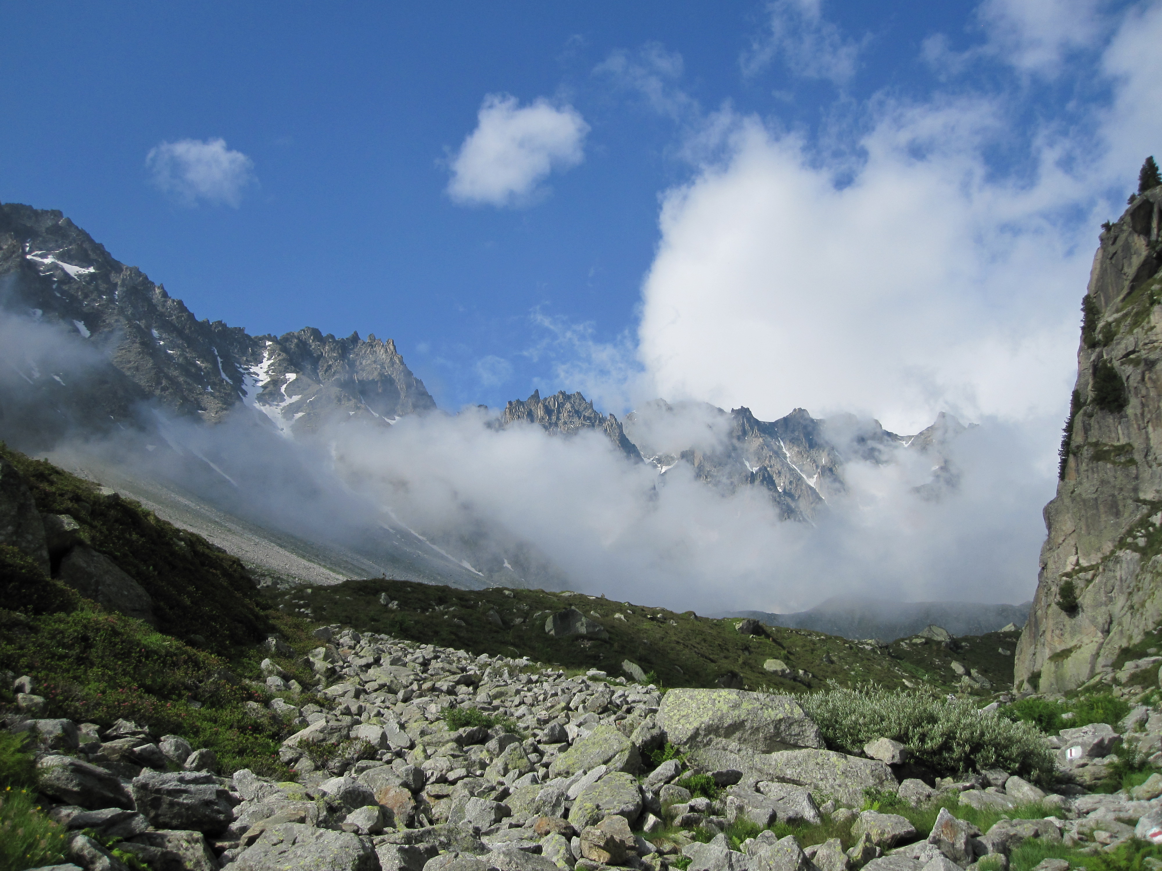
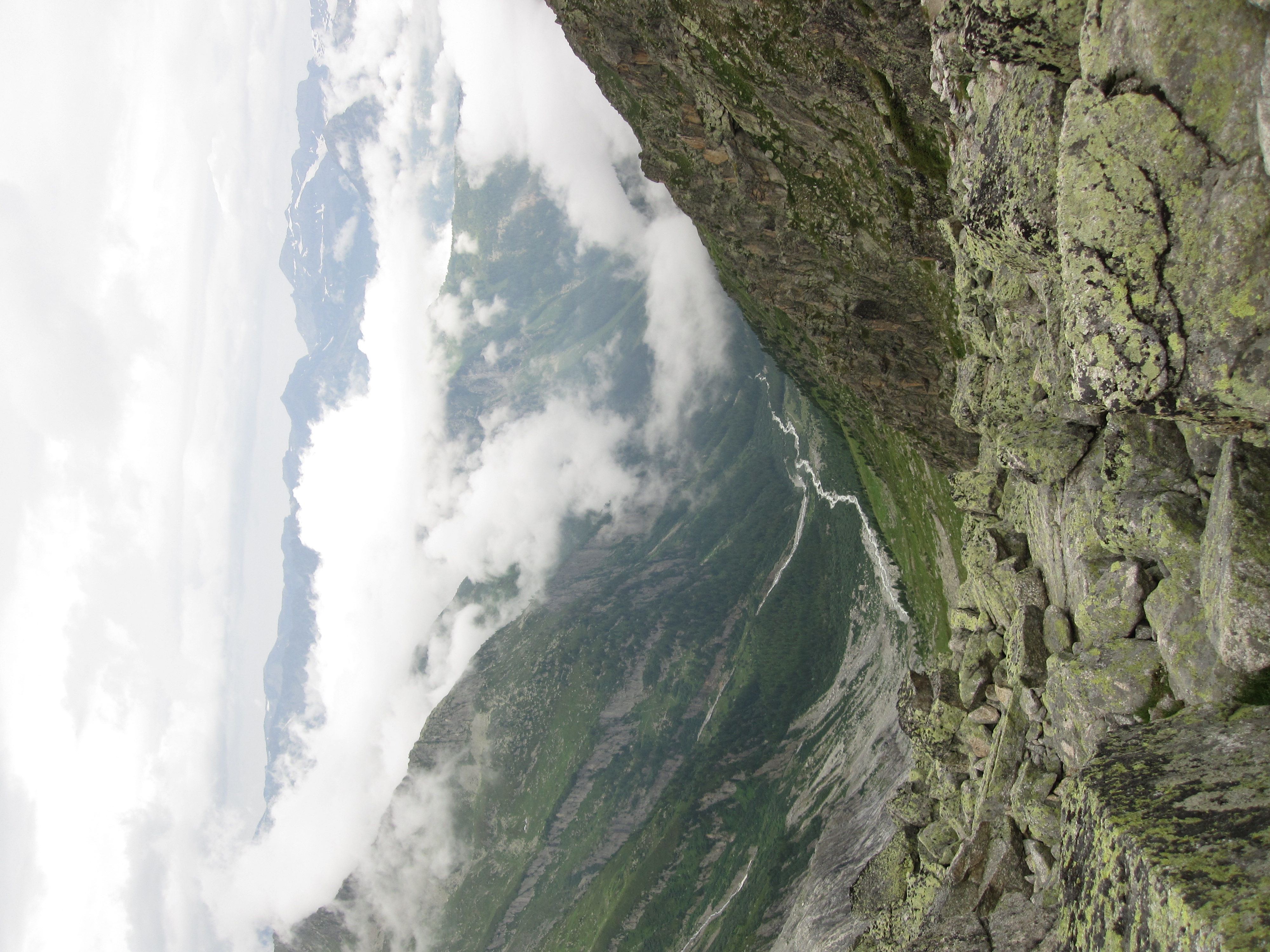
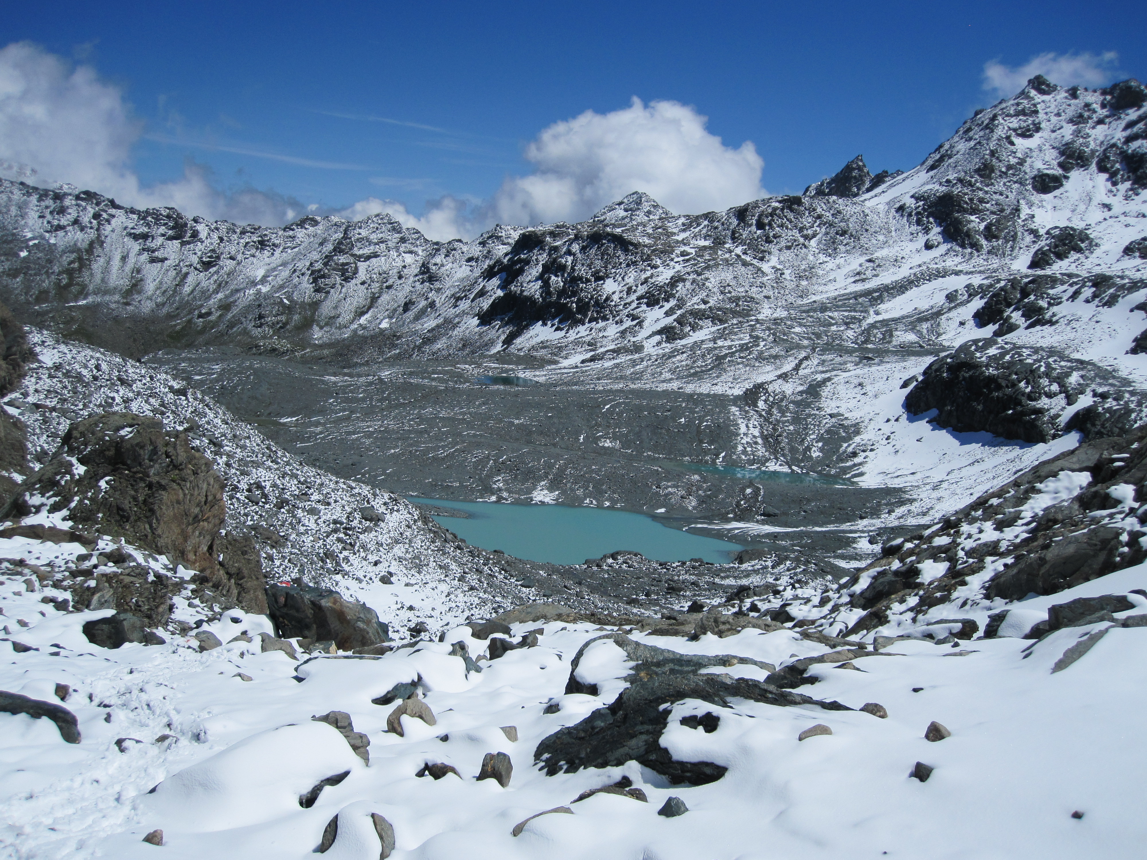
The Walker’s Haute Route from Chamonix to Zermatt takes the hiker on a visually stunning journey between Europe’s two most iconic mountains – Mont Blanc and the Matterhorn. Along the way, the trail passes by 10 of the 12 highest peaks in the Alps, as it winds its way through glacial valleys, alpine meadows, and enchanting villages.
I walked the Haute Route in 2009. All logistical details have been updated as of February 2019. Please note that the information below is largely directed towards independent hikers, rather than people going as part of an organized trekking group. If you would prefer to do a guided hike, see the list of recommended Haute Route agencies on Besthike.com.

Map from Wildernesstravel.com
At a Glance
Distance : 112 miles (180 km)
Avg.Time : 9 – 12 days
Start / Finish :
- Chamonix (France) – Zermatt (Switzerland)
- Which way?: I don’t think it makes a difference, though most people seem to begin their hike in Chamonix.
Transport
- Geneva is the closest major airport to both trailheads.
- Once you’ve arrived in either France or Switzerland, public transport to both towns is relatively simple. Multiple bus, shuttle and train options available. See Chamonix.net and Zermatt.ch for more details.
Season :
- Hiking season is generally between mid-June and mid-September. Accommodation in mountain huts is often full during July and August (see Sleeping below). If you plan on staying indoors, be sure to book ahead.
- Afternoon thunderstorms are common during the summer months,

Maps & Information:
- History: The idea for a high level route between Chamonix and Zermatt was first conceived by the British Alpine Club in the 1860’s. In it’s current incarnation, the Haute Route is renowned as both a summer hiking trail, as well as a cross country skiing route in the winter.
- Maps: Two very good maps by the Carte nationale de la Suisse cover the entire Walker’s Haute Route: #5003 Mont Blanc-Grand Combin and #5006 Matterhorn-Mischabel. If you’re unable to purchase them online, both sheets are widely available in Chamonix and Zermatt.
- GPS: See DenverDavis.com for free to download GPX and Google Earth KMZ files for the Walker’s Haute Route.
- Guidebook: I carried the Cicerone Press guidebook, Trekking Chamonix to Zermatt; The Classic Walker’s Haute Route. The latest edition (Kindle version also available) of this excellent resource was published in 2019. In addition to trekking notes and basic maps, it also contains useful information in regards to resupplying, travel, accommodation and other helpful tips.
- Trailblazer Publications also publish a Haute Route guidebook, however it hasn’t been updated since 2008. Go with the Cicerone option.
- Language: German & French. A basic knowledge of either definitely comes in handy, however, most of the locals along the route know at least a little English.
- Wildlife: Ibex, chamois, marmots, golden eagles, and if you are very lucky, lynx and wolves.
Resupply & Water:
- Ample on both counts.
- Supplies can be obtained in the villages along the way. Meals can also be arranged at all of the mountain huts (though not necessarily cheaply). Unless you choose to, you’ll never have to carry more than a couple of days food at a time. See the Cicerone Guide for details.
- Water: Similar story on the H2O front. I can’t remember carrying more than a litre at any given time. In regards to purification, I treated if there was livestock in the vicinity, but otherwise drank the water as is. I didn’t have any intestinal issues.


Route / Conditions:
- Navigation: A well-marked trail from start to finish. The main route is usually marked with red and whites stripes. From a navigational perspective, chances are all you will need are the sketch maps and trekking notes in the Cicerone guidebook (as well as a compass and/or GPS). However, if you’re interested in doing some side trips and/or just like a little more in the way of detail, I highly recommend picking up the aforementioned topographic sheets.
- Elevation: Although it may be easy to follow, the Haute Route is nonetheless a physically demanding trail. During its entirety, hikers will cross 11 mountain passes and negotiate more than 12,000 metres (39,370 ft) of combined altitude gain and loss .


- Recommended Stages: There are various route options along the way. Given reasonable weather, “not to be missed” stages/alternates include:
- Col de Balme to Chalet du Glacier.
- The crossing of the Fenetre d’Arpette.
- Cabane de Prafleuri to Arolla.
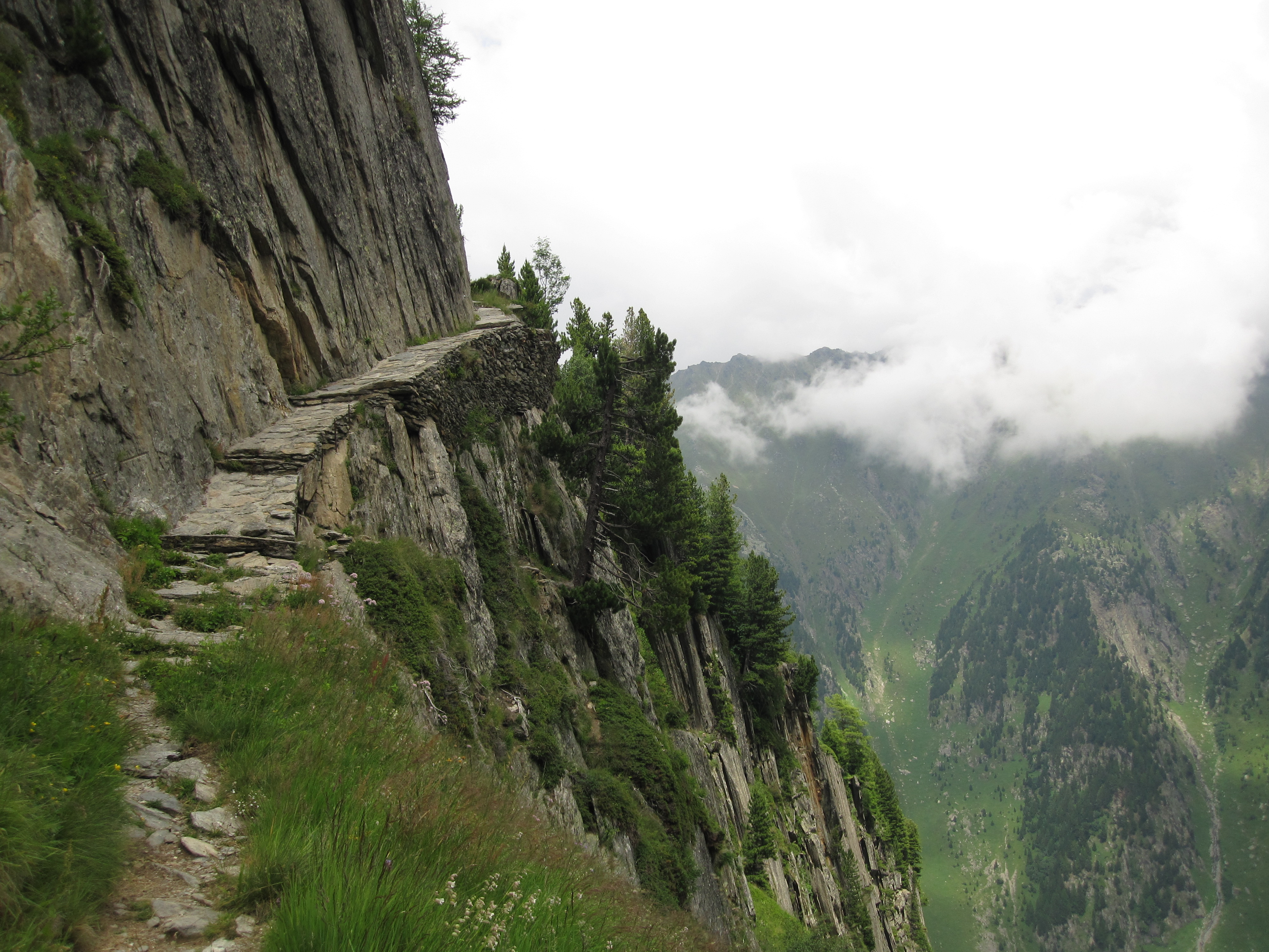
- The Europaweg for the final stage into Zermatt, rather than the valley floor route (Note: As of July 2017, this stage now includes the world’s longest suspension bridge. Spanning an amazing 494 meters (540 yards) across the Grabengufer ravine in Mattertal valley, at it’s highest point the bridge is some 85 meters above the valley floor).

Charles Kuonen Bridge on the Europaweg (photo from europaweg.ch)
- Tip – Timing Your Days: More than 90% of Haute Route hikers are part of an organized trekking group. From what I could tell, most of these parties seem to begin their hiking day around 8 am and finish about 2 to 4 pm. For the independent hiker this is a bit of a boon, as the trail is virtually people-free during what I consider to be the best times of the day (i.e. early morning and late afternoon). That being the case, my advice is to get out on the trail around dawn, enjoy a swim and/or a big lunch (in that order) in the middle of the day, and then hike until dusk.

Pas de Chèvre ladder on the Cabane de Prafleuri to Arolla stage.
Sleeping :
- Indoors: Due to the wide range of accommodation options available, 95% of hikers stay exclusively indoors on the Haute Route. The mountain huts in particular, are generally packed during peak season (Note: Be sure to book well ahead). For that reason alone, if you’re looking for a little more solitude than indoor accommodation can provide, I suggest carrying your own shelter.
- Camping – Officially: Official campsites along the route are situated at Chamonix, Argentière, Le Peuty, Col de Forclaz, Champex Lac, Arolla, Zinal, Randa and Zermatt. These can be pretty crowded during the summer months. On the flip side, they are cheap (as of 2019 between 10 and 15 Swiss Francs or Euros per night), and usually offer some or all of the following services: WiFi, kitchen, laundry, showers, and somewhere to charge your electronic devices.
- Camping – Not so officially: “Wild camping” is possible in the higher, undeveloped areas. In addition to being cheaper (you can’t get more affordable than free), another great benefit of adopting this strategy are the sunrises and sunsets. Instead of seeing them from the balcony of a mountain hut or a crowded village campsite, you gift yourself the opportunity to take in the wonders of both dawn and dusk from a higher, less crowded perch. Your only company will be snow capped peaks, exquisites tarns and maybe the odd marmot or two that’s trying to steal your supplies!
- Combo: All that being said, I highly recommend spending at least one or two nights in a mountain refuge. These atmospheric huts boast hearty food, red wine and more often than not, an international cast of diners. Sitting down and enjoying a meal and conversation with other trekkers, in some ways is as much a part of hiking between Chamonix and Zermatt as the spectacular mountain scenery.

Overview:
- The Haute Route encapsulates the best of the Alps in the space of 180 km of hiking. The scenery is great, the huts and villages are welcoming and the food and wine is top class. It is therefore no surprise at that when hikers talk about Europe’s finest long distance trails, the famed route between Mont Blanc and the Matterhorn is invariably one of the first names mentioned.
- Favourite stage: The crossing of the Fenetre d’Arpette.
- Favourite refuge: Refuge les Grands
- Favourite village: Jungen
- Tip: If you’ve got the time and inclination, I highly recommend also hiking the Tour du Mont Blanc while you’re in the area. Indeed, depending on route choices, the two classic trails largely coincide from Chamonix to the picturesque Swiss village of Champex.


Discover more from The Hiking Life
Subscribe to get the latest posts sent to your email.