The traverse of Southwest Tasmania consisted of two main stages – the west coast followed by the Arthurs Range. The summary below is from the first stage, a 17 day stretch from Cape Sorrell to Scotts Peak Dam.

Cape Sorrell Lighthouse
Note: For folks that have already read the initial trip overview, much of the information found in the logistics, maps and resupply sections has previously been covered. Feel free to scroll down to “Notes & Musings” to check out happenings from the West Coast section itself.
Stage 1 – Trip Details
Distance: 137 miles (220 km) approx.
Start: Hells Gates Jetty / Cape Sorrell (west of Strahan).
Finish: Scotts Peak Dam Trailhead
Time: 16.5 days
Daily Average: 8.3 miles (13.4 km)
Maps / General Info:
- I used a combination of the brief overview notes in John Chapman’s South West Tasmania guide and the TASMAP 1:25,000 Topographic map series (see list below).
- The TASMAP 1:25,000 series can be purchased online (paper & digital versions available). In addition, you can usually pick them up in person at the Service Tasmania Store in Hobart.
- For the west coast section of the traverse, I used a dozen topographic maps in total. These sheets covered the route from Cape Sorrell to the ‘Lost World Plateau’, at which point I linked up with the Port Davey Track. From north to south, the 1:25,000 maps were as follows: Kelly, Albina/Table Head, Meerim/Varna, Hibbs, Endeavour, Montgomery, Mainwaring/Veridian, Lewis, Elliot, Mulcahy, Settlement, Legge.
- For the final 25 mile (40 km) stretch along the Port Davey Track to Scotts Peak, I used the 1:100,000 South Coast Walks map.
- Note: In the Google Map above, the starting and finishing points of stage 1 and 2 are signified by the black marker pins.
Weather:
- Overall I was fortunate with the weather during the first stage. Lots of showers and drizzle, but not too much in the way of torrential rainfall.
Wildlife:
- One of my favourite things about this hike was the variety of fauna. Tasmanian Devils, wombats, seals, tiger snakes, starfish, sea anemones and yellow-tailed black cockatoos.
- Not-so-great was the fact that there were also leeches, ticks and plenty of mosquitos.

A none-too-happy Tiger snake that I accidentally woke up from a mid-afternoon siesta.

Tidal pools teeming with colourful marine life.
Resupply:
- Due to the remoteness of the west coast south of Strahan, it’s slim pickings on the resupply front. You either suck it up and carry food all the way from Cape Sorrell to Scotts Peak or organise for food drops by helicopter or seaplane (ballpark price = A$2000 / US$1500).
- In planning the Southwest Tasmania Traverse, I decided from the outset that I would carry all my own food for the entire west coast section. Mostly because I’ve always preferred to do my hikes unsupported. However, in the spirit of full disclosure, also because I didn’t want to shell out a couple of grand just to save me carrying an extra 9 kg (20 lb) from the start of my journey.
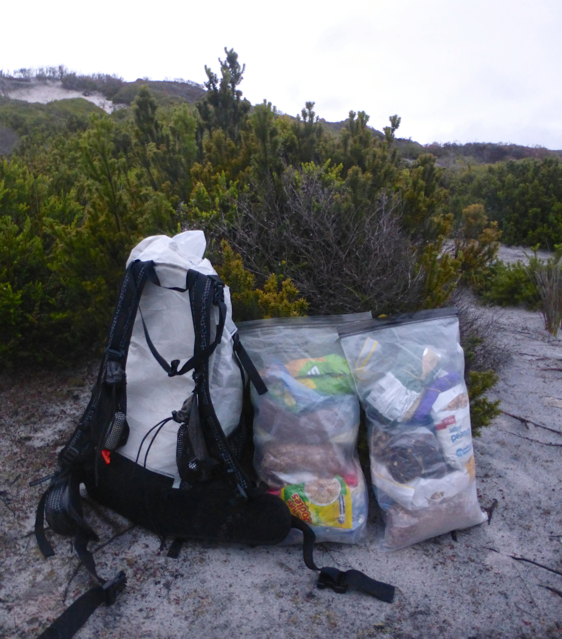
Food Bags at the end of Day 1 | Would thirteen days food fit in a pack with a 50 litre capacity? You betcha………but only just. The backpack pictured is the Hyperlite Mountain Gear 2400 Southwest model.
- I originally estimated that it would take me approximately 14 or 15 days (including an extra couple of days factored in for inclement weather) to reach Scotts Peak Dam. It ended up taking almost 17; suffice to say I was peckish by the time I arrived. That being said, I knew from about the fourth day onwards that I would take longer than originally anticipated, and subsequently rationed accordingly.
- Please note, I am in no way recommending that folks interested in hiking Tassie’s west coast use my itinerary or resupply strategy as a blueprint. Whilst I took 17 days to reach Scotts Peak, Chapman recommends between 28 and 35 days to do the same stretch – and that’s for fit and experienced hikers.
Water:
- Other than a few of the extended bushwhacking sections between Endeavour Bay and Urquhart River, I never carried more than a litre at any given time. As with my three previous hiking trips to Tassie, I didn’t treat any of my water throughout the trip and had no stomach issues.

Mid-morning breakfast & hydration break.
Notes & Musings
Prelude – Boat Rides, Lighthouses & a man named “Turk”
“Excuse me, mate, are you Robbie?”
“Yeah, I’m Robbie, who the *#!* wants to know?”, said the caretaker of the Macquarie Heads campground, just west of Strahan, Tasmania.
“Ahhhh……… I’m Cam Honan……..I called you on the phone about a ride over to the other side of the channel.”
“Oh yeah…….sorry, mate……..I’ve had a #*!* of a day. I thought you were from the campground. They never leave me alone from the time I wake up in the morning. I do everything but wipe their arses for em’.”
“No worries. I just arrived from Strahan. If you’re snowed under, there’s no rush in regards to heading off.”
“Nah………it will do me good to get away for a few minutes………..give us a few ticks and I’ll take you over.”
“Thanks, Rob. Much appreciated. Can I give you some cash for the ride?”
“Nah. A few bucks for petrol if you like. Sorry about the harsh words. It’s just been one of those days.”
“No harm done. We’ve all been there. As I said on the phone, I’m just here to do some hiking.”
And with that brief but colourful exchange, began the Southwest Tasmania Traverse.

Robbie heading back to Macquarie Heads after dropping me off at the jetty.
Robbie was as good as his word. Within 30 minutes of our meeting he had dropped me off on the other side of the channel at a little used jetty by the name of “Hells Gates.”
I couldn’t help but chuckle.
Set to begin what promised to be one of the most challenging journeys I had ever undertaken at a place called “Hells Gates”…….southbound, no less! Nothing for it but to channel my inner-Dante, rename my backpack “Virgil” and venture forth.

Virgil & I at Hells Gates.
I kicked off the hike with a side trip to Cape Sorrell lighthouse. Founded and first lit in 1899, this 40 m high (130 ft) maritime beacon (see photo above) was automated in 1971 and converted to solar power in 1998.
Along the way, I ran into a gentleman by the name of Turk McDermott, who owned one of the five or six fishing shacks situated near the tip of the cape. Turk and his family had been there for decades. Listening to him wax lyrical about the area’s fascinating past (e.g. the shipwrecks, colourful characters and biblical storms), gave me a personal insight into the region that I never could have gotten simply from checking wikipedia or reading text books. For a history buff like myself, I couldn’t have asked for a better start to my journey. As a bonus, the huts owned by Turk and his friends were regularly frequented by the state’s most famous animal, the Tasmanian Devil!

Tassie Devils foraging under the fishing shacks (photo courtesy of Turk McDermott).
Days 1 – 5: Cape Sorrell to Endeavour Bay
From a terrain perspective, the first five days were the easiest of the traverse. A combination of open beach walking and rocky coastline, mixed together with the occasional bushwhack and challenging gulch.

Day 2, Southwest Tasmania Traverse.
That being said, “easiest” is a relative term in this part of Tasmania; I still only averaged around 10 miles (17 km) per day. Nonetheless, it wasn’t quite as intense as some of the terrain I would be negotiating further south, and for that I was grateful. My pack was heavy (approximately 16.3 kg/36 lbs – 75% of which was food), I’d been battling a chest infection for the previous week and the plan was to pretty much stay in cruise-control for the initial segment to Endeavour Bay.
A mellow half days hike to kick things off was exactly what I needed. I followed that up with a second day that was longer and tougher than anticipated, but nonetheless not too strenuous. A very welcome bonus at day’s end came in the form of Giles Fishing Hut, a recently restored shack that sported a cupboard full of food, a gas stove and an empty keg of beer. Two out of three ain’t bad:
Gulches
For the first fifteen days of the traverse, one of the most challenging aspects was negotiating the gulches. Not only were these little chasms of fun steep and slippery, but if you happened to get your timing wrong, the price would be a freebie ride in Poseidon’s Washing Machine – the super-heavy duty cycle. Indeed, often I would sit and watch the sets of waves coming in for 10 to 15 minutes before attempting the more difficult gulches. It’s hard to over-emphasize the importance of exact timing in these situations, but the photos below might give you somewhat of an idea:

Same gulch, one minute between photos.

I had crossed this two-tiered gulch on the right hand side of the image, not more than 30 seconds prior to taking the shot.
The Comeback
By the third and fourth days I was starting to feel myself again. My pack was getting lighter, my health was improving and my hiking legs were returning. The weather gods were also smiling on me. So much so that at the end of day 4, I decided to reward myself with a mid-afternoon finish, a swim in the Indian ocean and an hour-long siesta. As an added bonus, Mother Nature even treated me to a sublime sunset, which I gratefully soaked in from one of the most scenic campsites I had enjoyed in a very long time. Life was good. Little did I realize what was just around the coastal corner.

Sunset at Evans Creek (My tent for this trip was the Mountain Laurel Designs Solomid)

Sunset at Evans Creek 2
PLB Blues
From the penthouse of Evans creek to the outhouse of Point Hibbs.
During a Day 5 side trip out to a seal colony on Point Hibbs, I took a bit of a slip and the EPIRB (Personal Locator Beacon) I was carrying in my hip belt pocket, was submerged in seawater for approximately 8 to 10 seconds. Almost immediately afterward I noticed it was making a sound. In order to stop the sound, I broke the seal and followed the instructions on the back of the device in order to disconnect it (i.e. extend the aerial and then latch/tape it back into place). No worries. There was just one little problem……….the EPIRB continued going off.
“You’ve got to be kidding me; is it disconnected or not?”

Hibbs Pyramid
For the next eight hours I continued hiking, the PLB kept beeping and I periodically gazed up to the heavens waiting to see a Search & Rescue helicopter.
“Surely my hike isn’t going to end because of a malfunctioning #!*! EPIRB?”
I couldn’t help but have an ironic chuckle. This was literally the first time I’d carried a PLB of any description in all of my years of hiking and the thing malfunctions! (Note: On a couple of previous trips, my hiking partners had toted one).
Finally, it was time to go to sleep. The EPIRB was still belting out its Road-Runner like tune, but by this time I knew that no helicopter would be coming. The disconnect must have worked. That was a relief; the only question was, how long would it keep making this infernal sound before the battery died?

I woke up seven hours later to the sound of wind and waves. But no beeping. Good.
Over breakfast, I weighed up my options. Either head back to Strahan and organize another PLB (which would have meant at least an extra week) or continue hiking along one of the world’s most rugged coastlines with no means of communication if something went wrong.
Who was I kidding? There was only one choice. Onwards.

Campsite at Endeavour Bay.
Days 6 – 8: Endeavour Bay to Urquhart River
This was the toughest stretch of the entire traverse. In the three days, it took me to hike between Endeavour Bay and the Urquhart river I covered a grand total of approximately 11.5 miles (18.5 km). An average of less than 4 miles per day.
The section around Christmas & Hartwell Coves, in particular, stood out for its unrelenting nature. A combination of shirt-ripping, leg-gashing, patience of Job-testing bushwhacking, mixed together with some very sketchy climbs in and out of wave-smashed gulches.

Bushwhacking between Christmas and Hartwell coves. A pair of gloves and long gaiters are worth their weight in gold when negotiating this type of terrain.

Christmas Cove

Mother Nature’s Infinity Pool | Day 8, SW Tassie Traverse.
It was a challenging stretch by any criteria, but I knew all along what I’d signed up for. The traverse of southwest Tasmania was an opportunity to experience on foot and by myself, one of the wildest coastal environments on the planet. It was a gift. An exhilarating, occasionally maddening, biggest-of-broad-smile-inducing gift. And I loved every moment unconditionally. Yep………..even the crappy ones.
Days 9-15: Urquhart River to Settlement Point
This section was significantly easier than the one that preceded it, as there wasn’t much in the way of treacherous gulches and the bushwhacks were generally shortish affairs.
In between the scrub bashing and coastal tip-toeing, there was often relatively easy walking across buttongrass plains (some of which had been burnt) situated immediately inland from the seashore. The trick with these stretches was to stay high on the ridges whenever possible, thus avoiding the denser vegetation and boggier terrain.

Hiking in the rain along one of the ridges that parallel the coast.
A Place with no Footprints
Every time I’d emerge from a bushwhack or a challenging rocky section on to a long stretch of white or golden sand, I’d break out into a big grin. Mostly because it was a welcome respite. But also due to the fact that there were no footprints. A visible reminder that it was just me, the coast and the ocean. For a person that has always embraced solitude like a long-lost sibling, those moments were amongst my favourites from the entire trip.

Day 2, SW Tassie Traverse.

Modder River meets Indian Ocean | Sunset Day 3, SW Tassie Traverse.

Sunrise at Nye Bay | Day 14, SW Tassie Traverse.
The Mirage
Just after lunch on Day 14, I skirted around a rocky headland to reach the gorgeous Mulcahy Bay. Gazing out at the golden sands ahead of me, I saw what appeared to be a group of approximately 20 figures moving up and down the shore. I rubbed my eyes, blinked a few times and looked again.
Yes, there really were a bunch of people on the beach. This was a big deal. Apart from a fisherman I had spotted offshore on Day 4, they were the first folks that I had seen since leaving Cape Sorrell some two weeks before.

Mulcahy Bay……….see the little figures off in the distance?
It turned out that the group in question was the South West Debris Cleanup Crew, a Tasmanian environmental organization that since 1999, has been helping to clean the state’s remote southwestern beaches. Yes, even in one of the world’s most pristine wilderness areas you can still find rubbish.
I stopped and chatted with the party for about an hour. A great group of folks that were as surprised to see me as I was to see them. After hearing my story about the PLB, the head of the team, Matt Dell, offered to loan me his EPIRB for the remainder of my journey.
As an additional bonus, they also agreed to send my family a message from the satellite phone they had back on their boats. This gesture meant the world to me. By the time I met the Debris Cleanup crew I was already running a few days behind my original schedule, and whilst from a personal perspective it didn’t matter, it had been playing on my mind that my family might be a little concerned if I was running more than a couple of days late (i.e. As mentioned above, I’d originally estimated that the west coast section would take 14 days to complete).

A wet and windy Wreck Bay
After parting ways with Matt and his team, I headed inland to avoid some of the thick coastal scrub. The next few hours were relatively quick going as I made my way along the ridges to Wreck Bay. By the time I arrived, the wind had picked up and it was raining steadily.

Wreck Bay | Day 14, SW Tassie Traverse.
Wreck Bay was named after the 1914 shipwreck of the “Svenor.” Up until a few years ago, this site was significantly more impressive (see photo below). However, in recent times Mother Nature in the form of some very heavy storms, reclaimed most of what was left of the wreckage, leaving only a fraction of the shell.

The “Svenor” | Above – what it looked like in March, 2016, and; below, how it appeared in the early 2000’s (photo from Tasmanian Parks & Wildlife Service).
The Paddle
On Day 15 I awoke to the sound of rain on cuben fiber. Poking my head outside the tent and scanning the horizon, it looked like the weather had set in. It was going to be dampish.
After one final bushwhack to get through the dense scrub band that bordered Wreck Bay, my course lay inland. Specifically, I would parallel and then climb up and over the De Witt Range before making my way down to Piners Point. Once at Piners, I would need to negotiate the final major obstacle of stage one, namely a 150-metre wide crossing of the very cold and deep Davey River.
The plan was to paddle across the channel on my Thermarest NeoAir, with my pack bobbing along behind me attached to my right leg with some guyline. It’s not as crazy as it sounds. Before heading down to Tassie, I’d done a few successful test runs with the same setup back in Queensland. Though in the spirit of full disclosure, I should mention that it is a tad warmer up in my home state and hypothermia is not really on the cards…………details, details.

Made it……..”you little beauty”!!!! (i.e. Australian for excited approval).
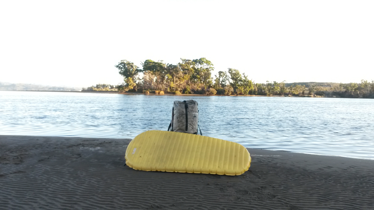
Virgil, Thermarest NeoAir (aka. The Mat with No Name) and the Davey River. That’s Piners Point in the background.
Days 16 & 17 – Settlement Point to Scotts Peak Dam
After a great night’s sleep, I woke up early the next morning to catch a gorgeous sunrise over the Davey River.

Unfortunately, the sun’s appearance was just a cameo, and as I sat and ate my breakfast, the clouds rolled in and it began to rain. From my campsite it was approximately 50 km to the end of Stage 1.
For the first 10 km, I hiked due east in the drizzle and fog across scrubby creeks and undulating buttongrass plains. The going was slow, but compared to what I’d come through, it was relatively easy. I then climbed a 1000 ft to the edge of a plateau known as the “Lost World.” It was midday when I reached the high point, and as if on cue, the clouds lifted and I was presented with a wonderful 360-degree panorama.

Hiking in the fog, just inland from Settlement Point.

The view looking back towards Settlement Point and the West Coast.
I smiled. Not only in thanks for the beautiful vista, but also because directly east from where I was standing, I could see a hiking trail. Specifically, it was the Port Davey Track, and it was on that well established (albeit somewhat muddy) pathway that I would head north to Scotts Peak Dam.
I ended up covering the final 40 km in one day. During the first 16 days I hiked approximately 180 km. It’s amazing what a difference a trail can make.

Port Davey Track.
At 4.30 pm the following day I finished the first stage of the Southwest Tasmania Traverse. Still to come was Stage 2, in the form of the Arthurs Range, arguably Australia’s most spectacular mountain chain. I couldn’t wait.
There was just one small matter that needed to be attended to; an out and back resupply hitch to the nearby town of Maydena. Which begged the question…………..would anyone pick up a guy that looked like this?

“No, I wasn’t mauled by a tiger. I just finished hiking down Tasmania’s west coast.” | Photo taken at Junction Creek, 8 km from the end of Stage 1.
Note: Click here for the trip report from the second and final stage of the Southwest Tasmania Traverse.
Discover more from The Hiking Life
Subscribe to get the latest posts to your email.
Amazing. Great article.
Hello sir.
I’m wondering where you camped night 6. And did you follow Chapman’s advised route regarding the section between Endeavour to Urquhart.
Thank you.
Sorry about the tardy reply. Currently on holiday and can’t remember where i camped that night off the top of my head. I’ll check when i return in November.
It’s ok. I don’t need to know everything. I’m going to do what you did from coast to coast via re-supply at Maydena also. Just researching and saving for gear (at single dad speed) I’m older too ☹️. With so much noise, biased reviews and self promotion, your website is a like fresh air. You busted out man! Proud of you.
A big thanks for your always fascinating blog. Makes for an inspiring read (just wish I was 30 years younger and did’nt have a dodgy back!). Oh well I’ll content myself with forays on the Bibbulman and a planned Swiss Haute walk in August. Best wishes and good luck on future ventures
Mike Ainley
Hi Mike,
Thanks for the kind words. Have a great time on the Haute route!
Cheers,
Cam
Fun read!
What an adventure! Great post, great blog!
I find a lost dog at Macquarie Head and was asked to contact Robbie, for dealing with it. All this good things make me think he is a superhero, even you would not say from the first look.
Haha. Great stuff, Viktor! He was definitely both a good guy and a colourful character! As I mentioned in the article, he helped me out big time in regards to that ride across the channel to Cape Sorrel.
Hello,
Just stumbled across this blog a few months late through the Bushwalk Tas forum. Absolute maddog, super inspiring and fantastic write up, thank you. I am trying to get into more lightweight hiking, and was blown away by the small size of your pack for 17 days! I am food-focused so always find that weighs alot – any chance you could post a list of your food for this trip (if you still have it), or point me towards where you have already done that? Just hoping to get some ideas. I did find your food section on this blog and there is some good stuff there. Thank you
Thanks for the kind words. I generally take the same sort of food on most of my trips. Lots of nuts, dried fruit, granola, powdered milk, dehydrated beans, natural corn chips, chocolate, some meal/energy bars and a few packets of noodles (without the seasoning satchels). I aim at around a kilo or just under of food a day, which generally equates to around 4500 to 5000 calories. Hope this helps.
Cheers,
Cam
That was a great coastal stage hike! Isn’t it great to be that UL that when needed 2/3 of the volume in the HMG 2400L hauler can be food?
It’s not the rag tag clothing look that scares people it’s that Jack Nickleson One Flew Over the Cuckoo’s Nest expression. 🙂
Hey Dogwood,
It was a hike I will never forget. In all respects, definitely one of the more challenging trips I have done over the years.
As for my expression, it was a mixture of pure joy, pure relief and yes, maybe just a hint of Nicholson’s edgy madness! (I love that film and book!).
Cheers,
Cam
Hi Cam I am looking into doing this trek, What would you recommend food wise for the trek?
Hey Brendan,
I opted to carry all my supplies for the whole section between Cape Sorell and Scotts Peak Dam (16/17 days). However, the handful of other folks that I have heard about who did this trek (or a shorter version finishing at Bond Bay), all opted for food drops. They also took around four to five weeks to finish it. Pickup John Chapman’s book “South West Tasmania”, in which he gives an overview of food drop options for the West Coast.
I need to emphasise that this trek is a very big step-up from the Arthur Range. There is a good chance you may not see anyone for two to four weeks. I’d really only recommend giving it a try if you have a lot of wilderness experience. It would also be best to do it with at least one other person. I’m not meaning to put you off or be dramatic, but the weather, river crossings, bushwhacking and climbing in and out of the seaside gulches on the West Coast is no joke.
Cheers,
Cam
hey mate was wondering if you have the gpx route from Strahan to the port Davey track as i’m going to do the same except once I hit the port Davey i’ll go right to melalucca and resupply there and go out the south coast track thanks mate.
Sorry I don’t; I used maps and compass. I just took the occasional waypoint which appear on the google map of the route. Best of luck.
Well done Cam, I have been along this coast several times, however rather than rush through spend time in each of the magic areas. To the punter this trip might appear to be quite straight forward but unless you have been there or spoken to someone to obtain good information it most likely is going to be a not so pleasant experience. (The sawn Tops of the Huon Pine sticking out of the sand at Christmas Cove was completed by me for survival mode reasons)!!!
Hey mate I grew up in that area , and what a story. I also remember turk McDermott, I used to be neighbors with his brothers family , As a young fella.
haven’t really been back there since primary school but I’m heading back to explore, it’s god’s country down there. And to love the encounters , everyone that stays down there is a genuine colourfull character.