Date: November 19 – 26 (7.5 days)
Start: Basaseachic Falls
Finish: Creel
Distance: 143 miles (230 km)
Daily Average: 19.1 miles (30.7 km)
Total Distance: 143 miles (230 km)
The Beginning
Our trip began at Basaseachic Falls (246 m / 807 ft). Located in the northwest corner of the Copper Canyon region, Basaseachi is second highest waterfall in Mexico after Piedra Volada (453 metres / 1486 ft), a seasonal cascade located 7 km further south.
Route
The first section of the Copper Canyon Traverse (CCT) linked together two of the region´s six major canyons, namely the Candamena and the Oteros.
It was a mixture of canyoneering, little-used trails, dirt roads and plenty of gear ripping, shin busting, expletive peppered bushwhacking. How bad was the bushwhacking? By the end of Day 2, the side pockets on both our backpacks had been torn, I had lost my trekking pole which had been strapped to the side of my pack, and my hiking shirt looked like it had been lifted from the wardrobe of the Incredible Hulk………..albeit a somewhat skinnier version of the big guy.

Descending Candamena Canyon.
During this initial period, our daily mileage fluctuated dramatically depending upon the conditions encountered. For example, on the aforementioned day two whilst descending the often technical upper reaches of Candamena Canyon, we managed only 6.5 miles total. In contrast, on the fourth day into Uruachi we covered approximately 35 miles on easy to follow single track and dirt roads.

“Assisted” hiking in the Candamena Canyon.

Drug cartel graffiti at an abandoned mine.
Gerry the Gold Standard
Whilst wandering the backcountry of developing nations, it´s not uncommon to encounter folk making their way from village to village. When the path is far from clear, chances are you may be inclined to ask one or two of the locals for directions. Their response, irrespective of the conditions, usually goes something like: “Just keep going straight………follow the main path…………you can´t miss it………..you´ll be there in an hour tops.” In reality, this more or less translates as follows: “There will be a major junction within 10 minutes, there is no clear path and you have Buckley´s chance of arriving at your destination before day´s end.”
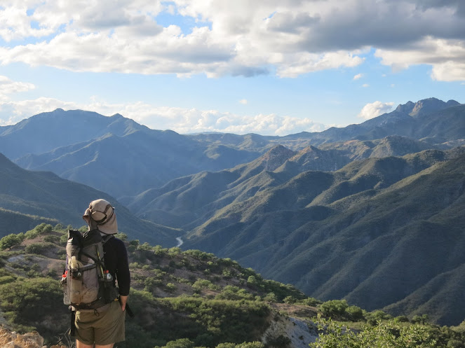
Cam Honan overlooking the Candamena Canyon.
Fast forward to November 21, 2013. Just after breakfast, we met Gerado (Gerry), a farmer from the village of Candamena. Not only did Gerry give us what turned out to be spot-on directions for the rest of the day, he also provided eerily accurate time estimates, terrain descriptions and invited us to stay at his farm next time we happened to find ourselves in the Candamena. Quite simply, the gold standard by which all future third-world directional advice will be measured.

Justin Lichter | Oteros Canyon.
No Thanks, we´re Walking
During the final dirt road stretch into the spectacularly situated village of Uruachi, we were passed by nine vehicles over the course of a seven-hour period. All but one of these cars and trucks stopped to ask if we were OK and if we wanted a ride. Although we declined all offers, both Justin and I couldn´t help but be struck by the genuine friendliness shown to us. In a region (i.e. northern Mexico) which receives almost exclusively negative international press due to drug and violence issues, the hospitality we were afforded during our time in the canyons was universally positive.

Justin Lichter | Oteros Canyon.

Cam Honan fording/swimming in Oteros Canyon.

Cam Honan hoping for the best at a dodgy water source.
Related Posts
- CCT Stage 2 – Creel to Divisadero
- CCT Stage 3 – Divisadero to Batopilas
- CCT Stage 4 – Batopilas to Cumbres de Sinforosa
Discover more from The Hiking Life
Subscribe to get the latest posts sent to your email.
So stoked to see a first report! That’s an incredible waterfall.
Very impressed.
A great place to start the hike!
Fabulous-You are certainly among the first, and probably the first and only since, to do this traverse. I first visited Basaseachic in 1976, and subsequently made about 10 trips to the region between 1977_1990, including 3-month and 6-week stints in Batopilas, and a 10-day hike from Cusarare to Batopilas, crossing the Unique River at seldom-visited Barranca de Cobre. What great adventures have you had since then? I’m writing you from Mozambique, by the way. I finally revisited Batopilas in 2019, a delightful trip down memory lane.
My pack was packed, had a c-130 chartered and was ready to jump in for the rescue mission. Glad to see its not needed. Loved the first report, looking forward to more.
I hope you were packing a box full of Reese´s Peanut Butter Cups……….
Thanks, Mary!
Have they put more than a single rail around the viewing area at the top of the falls? That’s all there was when my husband and I visited there decades ago..the potential danger of a rambunctious child falling without protective fencing really scared me. In 1963 my husband was on a river trip on the Urique but the water was so low that they mostly carried the rafts. The trip didn’t end well..it was mostly ‘every man for himself’ to climb up out of the canyon and wait for the train back to Creel, unknown hour or day that it would pass by. The friendly Tarahumara Indians offered gruel and their delicacy of toasted ant abdomens..he was happy for the gruel!
Hi Janet,
Once again, thank you very much for the message.
As of 2013, there still wasn’t a lot in the way of barrier protection at the top of Basaseachi Falls. Definitely a place where you would want to keep a close eye on your kids.
The water levels in the Urique can fluctuate a lot depending on the rainy season. Having hiked/climbed out of that canyon a few times myself over the years, I can vouch for the fact it is far from an easy proposition…….I imagine even more so when trying to haul out a raft!
Cheers,
Cam