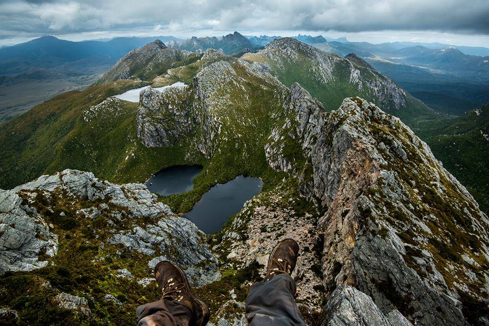
The Western Arthurs Traverse (WAT) is one of Australia’s most spectacular and challenging treks. Situated in the Tasmanian Wilderness World Heritage Area, it’s a lollipop-shaped route that negotiates the western section of the famously rugged and inclement Arthur Range. Encapsulating a dramatic collection of jagged quartzite peaks, hanging valleys and glacier-carved lakes, the route is suitable for experienced hikers armed with good scrambling skills, storm-worthy shelters, and a stoic’s disregard for mud and driving rain. The planning guide below features map recommendations, logistical information, tips and trekking notes, and last but not least, some incredible images from Viktor Posnov.

Lake Uranus | Western Arthurs Traverse (photo by Viktor Posnov).
Note: Since 2002 I have trekked the western section of the Arthurs on three occasions. During my most recent visit in 2016, the entire Arthur range represented the final stage of what was a 24-day traverse of Tasmania’s Southwest Wilderness.
At a Glance
Distance: 49 miles (79 km) approx.
Difficulty Level: Challenging
Start / Finish: Scotts Peak Dam (aka Port Davey Track Northern Trailhead).
Permits: As of December 2018, no specific permit is required to hike the WAT, however, all hikers will require a Tasmanian National Parks Pass. These can be purchased online, at National Park Visitor Centres, Service Tasmania Shops, and most accredited Tasmanian Travel Information Centres.

Western Arthurs Traverse Overview Map (From the first book in my Wanderlust series of hiking books: “Wanderlust: Hiking on Legendary Trails“)
Average Time: 5 – 8 days
- The time needed to do this hike can vary considerably depending on the conditions, as well as the fitness and experience of the hiker in question. As a general reference, John Chapman, the author of the excellent South West Tasmania hiking guidebook, suggests between 10 to 12 days. Personally, I think this is a conservative estimate. I would say five to eight days would be a more appropriate time frame for most aspirants, given a relatively light pack weight (i.e. no more than 7 kg base weight), a good level of fitness and experience, and a mixed bag with the weather.
Season:
- December to March. Snow, high winds and heavy rain are possible at any time of year.
Direction of Travel:
- Although the hike can be done in either direction, I’d recommend going in a counter-clockwise direction. This places the prevailing winds at your back when you are up on the crest, no small thing when the Roaring Forties (see below for details) are coming through, rain is pelting down at a 45° angle, and you’re scrambling up and down an exposed knife edge.

Yours truly about to make the descent to Lake Oberon in uncommonly fine conditions.
Getting There and Away:
Scott Peak Dam is situated about three to four hours drive from Hobart. As of December 2018, there are no public transport options to the Scott Peak Dam trailhead.
Shuttle: If you don’t have a car, Tasmanian Wilderness Experiences run on-demand shuttles, which require a minimum of two people.
Bus & Hitching: If you are by yourself and looking to save some cash, consider catching a bus to Westerway from Hobart (approx. 2hrs). From this point, you’ll need to stick your thumb out. It’s approximately 50 km from Westerway to the turn-off to Scotts Peak, and then another 33 km along the well maintained Scotts Peak Dam Road to the trailhead. It has been my experience over the years that as long as you look semi-presentable and have a smile on your face, hitching is still pretty easy in Tassie once you’re out of the bigger towns.

Lake Oberon (photo by Viktor Posnov).
Maps & General Information
- TASMAP 1:25,000 – Three topographic maps cover the entire route. They are Crossing, Razorback and Glovers. TASMAP’s topographic maps are available for digital download (A$2 each as of December 2018).
- TASMAP 1:100,000 Old River. Useful for overview purposes, however, when the weather turns nasty, you will be glad you are carrying the 1:25,000 maps.
- John Chapman’s South West Tasmania includes maps and trekking notes. Now in its 6th edition (2017).
- Western & Eastern Arthurs Traverses Facebook Group – A good source for up-to-date information on hiking conditions in the range.
- GPS info for the full route on Wikiloc.
- Do I really need to take all of that?: In this day and age increasingly more people are leaving paper maps and compass at home, and having all their navigational eggs in the one electronic basket (i.e. their smartphone). I don’t recommend doing this for the Western Arthur Traverse. The terrain and weather in this area is no joke, and if something happens to your phone during the trek, you may well find yourself stranded up poo creek without a technological paddle. My advice is as follows: 1. Download all three of the 1:25,000 maps and the two 1:100,000 maps. Have them on your phone and print them out as well. Keep all information in sealable plastic bags; 2. Buy Chapman’s book, and take photos of the trekking notes to keep on your phone for reference purposes; 3. Take a compass and keep track of where you are on your maps at all times.
The view from Mount Scorpio | Western Arthurs Traverse (Photo by Viktor Posnov).
- Food: This is a wilderness trek and there is nowhere to buy food along the way. You will need to carry everything you need from go to whoa. While I would never recommend rushing during a hike, due to the rugged nature of the terrain, I would suggest trying to finish the Western Arthurs Traverse in eight days or less. This may mean slightly longer hiking hours than usual, but the payoff is less weight on your back while out on the trail.
- Water: For the most part, H2O can be found in abundance. That said, there is a high-level stretch or two – the Beggary Bumps comes to mind – in which aspirants will need to carry sufficient water for four to five hours of tough hiking. See Chapman’s guide for details.
- Trip Reports – 1. David Noble Blog (abbreviated version of the WAT via Kappa Moraine); 2. Walking with Wired (full WAT); 3. Western Arthurs – Viktor Posnov’s Photo Journal.

Yours truly looking back over the Beggary Bumps.
Trekking Notes
The Rollercoaster : The highlight of the Western Arthurs Traverse is the 30 km (18 mi) plus stretch along the range’s undulating crest. During this section pretty much all of the trekking will be either steeply up or precipitously down. If you’re looking for a hike in which you can stretch out and cover big distances, it may be best to look elsewhere. In the Arthurs 1 to 1.5 km per hour is generally very good going. That being said, the payoff for all your exertions comes in the form of consistently jaw-dropping vistas, and the satisfaction that comes with meeting and adapting to the rigours of unforgiving environments.
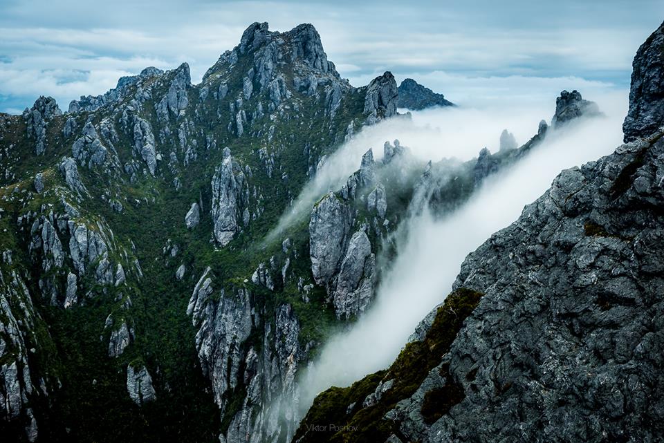
Cloud creeping through the jagged quartzite ridge line (Mount Hayes side trip / Viktor Posnov).
The Muddy Plains and Staying on Track: With all the precipitation it receives (see Weather below), it is no surprise that there is quite a bit of mud in the low-lying areas around the Arthur Range. During the WAT hikers will likely encounter boggy conditions pretty much everywhere except the crest. The most sustained section of mud-slogging will likely be the 19 km (11 mi) stretch from Cracroft Crossing to Junction Creek. Please resist the urge to “bog skirt”, as this will contribute to erosion, damaged vegetation, altered hydrology and a widening of trails. Suck it up, accept the conditions for what they are, and wade on through.

Kiwi Dave on the Arthurs Plains during our 2002 Western Arthurs Traverse.

The opening/closing stretch from Scotts Peak Dam to Junction Creek is not without its boggy moments as well.
Overgrown Terrain: Quite a few parts of the trail between the Moraine K junction and Lake Roseanne are overgrown due to a comparative lack of use (see Alternates below). Many hikers will feel more comfortable wearing a long sleeve shirt and pants during this section.
The Weather: One cannot talk about hiking in Tasmania’s southwest wilderness without making special mention of the weather. On average it rains 250 days per year in this part of the world. And I’m not talking drizzly Seattle or UK-type precipitation. The Arthurs plays host to some of the wildest and most unpredictable conditions on the planet. Thanks in no small part to the Roaring Forties – gale-force westerly winds found in the Southern Hemisphere, generally between 40° and 50° latitude – backcountry trips in this range are a barometrical roll of the dice at any time of year. In addition to a storm-worthy shelter and good wet weather gear, an ironic sense of humour is highly recommended.
TIP: Make miles while the sun shines – The odds are very good that you will encounter dodgy weather at some point during your hike. That said, storms often pass as quickly as they arrive in this part of South West Tassie. That being the case, when you are presented with a clear meteorological window, be sure to make the most of it. This occasionally may translate to hiking longer hours, in order to compensate for the other times in which you will need to cut your days short due to inclement conditions.

‘Watching the storm roll in, and then I watch roll away again’; an Otis Redding moment in the Arthurs (Photo by Viktor Posnov).
Pack Weight: I cannot over-emphasise the importance of keeping your pack weight at a reasonable level for the Western Arthurs Traverse. In any type of terrain, a lighter pack will translate to a more enjoyable on-trail experience. However, in a rugged environment such as the Arthurs it makes an even bigger difference, not only in terms of hiking comfort but also in regards to safety. For example, when you are scrambling up and down slippery rocks and root-laden cliffs in the pouring rain, a lighter pack will translate to not only enhanced agility but also free your mind of the burden of a heavy load, so you can focus solely on the job at hand.
This planning guide is not the place for an in-depth gear weight discussion. If you are interested in dropping your base weight without compromising safety (in actual fact you will be increasing it), check out the Gear and Going Light sections of the website (see top navigation bar), or take a look at “Tips for Hiking in Cold and Wet Weather”, for environment-specific suggestions.

Square lake (photo by Viktor Posnov).
Camping
The challenging nature of hiking in the Arthurs is somewhat mitigated by the fact that there are a series of established campsites situated at regular intervals along the route. Most of these are located in “relatively” sheltered spots with water sources close by. In other words, when the elements have taken an inclement turn and/or your energy levels are low, you will never have to go too far before you can potentially call it a day.
On the crest, the main camping areas sport timber platforms. They also have modular toilets, which can be flown out by helicopter when full. Neither of these features are aesthetically pleasing, however, they play an important role in helping to minimise the damage to the Arthurs fragile alpine environment. No small matter, considering the increase in hiking numbers in recent years.
In regards to camping on these timber platforms, most of them have nails and pre-tied pieces of rope along the edges which will help to make pitching easier. However, this is by no means guaranteed. Just in case, be sure to bring along some extra guyline in order to tie-out your tent.

Wild campsite at the West Portal (photo by Viktor Posnov).
Alternates
Due to the often inclement nature of the weather in the Arthurs, many (most?) hikers choose to do abbreviated versions of the WAT. The two main bailout points are Epsilon Moraine (situated a little NW of Mount Orion) and Kappa Moraine (aka Moraine K). The latter represents the most common alternate and cuts off approximately 30 km (18 mi) from the overall distance. Both of these alternate routes link up to the Mackaye Track, which leads back to Junction Creek and the Scott Peak Dam trailhead.

Kiwi Dave gazing out towards Promontory Lake from just above the Moraine Kappa Junction | Western Arthurs Traverse, 2002.
Six Recommended Side Trips
Many of the best views during the Western Arthurs Traverse come from doing side trips along the route. Below are six of the most highly recommended excursions:
- Mount Hayes: Stage 2 – Lake Cygnus to Lake Oberon) – 600 m / 40 minutes return
- Dorado Peak: Stage 3 – Lake Oberon and High Moor – 1.2 km / 2 hrs return
- Mount Columba: Stage 3 – Lake Oberon to High Moor – 500 m / 15 minutes return
- Mount Aldebaran: Stage 4 – between High Moor to Haven Lake – 2.2 km / 2 hours return.
- Mount Scorpio: Stage 5 – Haven Lake to Kappa Moraine Jct – 100 m / 10 min return.
- West Portal: Stage 7 – Promontory Lake to Lake Rosanne) – 800 m / 40 min return.

Side trip to Dorado Peak, in Western Arthurs Range. In Viktor’s words: “It was crazy weather all day; it was sunny on the western side of the range, but the Southern side of the mountains was covered in a blanket of very thick fog.” (Photo by Viktor Posnov).

Experiencing a beautiful sunset in a place renowned for stormy weather is a little like kissing a girl you have long admired from afar, but never thought you had a chance with. You can’t quite believe it is happening, but when it actually does you don’t want it to end | Sunset from the West Portal (photo by Viktor Posnov).
FAQ’s
I’m not sure if I have the experience to do the Western Arthurs traverse of the Arthurs. Can you recommend easier and shorter options in SW Tassie?
Yes, the South Coast Track and Mount Anne Circuit represent shorter and mellower alternatives. Chapman’s book contains all the information you will need.
Do I need to bring rope?
In his guide book, Chapman recommends bringing 20 meters of rope for pack lowering purposes. I respectfully disagree. If you’re in good shape, have decent scrambling ability, and your pack doesn’t weigh the proverbial tonne (and really you should tick all of these boxes if you are planning on doing this hike), rope isn’t necessary. Indeed, in my opinion, it will only add more weight to your pack, making an already challenging hike even harder than it should be.
I’ve heard it said that the Western Arthurs is superior to the Eastern section; is this true?
No. The western part of the range is easier to access, and with the exception of Federation peak, it is the more popular part of the mountain chain. However, having hiked the entire range in both directions, in my opinion, the whole chain is equally beautiful, equally challenging, and hikers are equally likely to feel the brunt of the elements, irrespective of whereabouts they are situated between Scotts Peak Dam and Farmhouse Creek (the eastern-most terminus). For those interested in a traverse of the entire range, see the Arthur Range Traverse Planning Guide.
Related Posts
- Arthur Range Traverse Planning Guide
- Southwest Tasmania Traverse: Stage 2 – The Arthur Range
- Southwest Tasmania Traverse: Stage 1 – The West Coast
- Arthur Range Gear List
- Tips for Hiking in Cold and Wet Weather
Summary
Hiking in the Arthur Range is an exercise in patience, perseverance and meteorological faith. If you are afforded an extended stretch of fine conditions, consider yourself fortunate to have witnessed some of the best mountain scenery in Australasia. On the other hand, if a big storm front rumbles through and all you see is horizontal rain and thick fog for three straight days, simply shrug your shoulders, have an ironic chuckle and try to remember that Mother Nature doesn’t have a copy of your hiking itinerary. Either way, hiking the Western Arthurs Traverse will be a trip you will never forget.
Postscript: For more amazing images from the Western Arthurs Traverse, see Viktor Posnov’s Western Arthurs compilation. You can also follow him on instagram, facebook and Flickr.

(L to R) Cam Honan and Viktor Posnov | For the lowdown on how Viktor and I met in 2016, see The Ukrainian from Cincinnati.
Discover more from The Hiking Life
Subscribe to get the latest posts sent to your email.
Hey there,
Greetings from a fellow blogger and hiker from Bulgaria. I admire what you do and I often read your blog.
I really hope to be able to hike in Australia.
This traverse looks like a challenge and I definitely love facing those.
Is it dog-friendly?
No, the trail is not dog friendly. As is true of most national parks across Australia, dogs and other pets are not allowed into Tasmania’s national parks and nature reserves.
I saw in the photo you have on longer gaiters then The dirty girls I think you usually wear. Did you take trail runners for the trip? If you did, wouldn’t traditional gaiters slip from under the shoe?
Yes, I was wearing trail runners on that trip (actually all my Tassie hikes since the early ones in the 90’s).
Those particular gaiters are very light (75 grams), made of eVent, and attach around the bottom of the shoe with bungee cord. They don’t tend to slip too much, but the bungee does wear out quickly .
Hi,
Piggy backing on this for a couple of gear questions:
-Are those event gaiters the MLD ones? Did you find they held up OK? I have a set but was going to bring some non-waterproof nylon outdoor research ones that are a but more sacrificial… Although I was planning to only really wear them in the muddy sections so even lighter would be better…
-What sleeping bad rating do you recommend for the WA? I’m doing it in early March and am tossing up between a couple of quilts I own.. I had been planning on taking a synthetic one to better handle the moisture in the air, but it’s only rated to freezing so I’m wondering if I should just bring my (also lighter) down quilt that is rated to -6.. what do you reckon?
Hi Lachlan,
Thanks for the message. In answer to your questions:
1. Gaiters – I think shorter/lighter ones would be fine. You just want something to keep all the mud/debris out of the top of your shoes.
2. Quilts – I’ve never found humidity to be a concern on any of my Arthurs trips. Out of the two quilts you mentioned, I’d opt for the down model.
All the best on your trip.
Cam
I hope one day I can actually go there. Thanks for all the info!
Awesome photos.
Abrazo!
Nice write up. What would your pack weigh in totality – for this circuit? It didn’t look very heavy in your pics, considering you’d need over a weeks worth of food. I’d be at around 22kg as I was for 4 days on Frenchmans in Winter.
Hi Chris,
Based on previous traverses of the Arthur Range in 2015 and 2016, I’d say around 8 to 9 kg total (approx. 5kg base weight + 3 to 4 kg of food). Given average weather, that would equate to a fairly comfortable four-day hike.
Cheers,
Cam
great guide!
Thanks for a write up as what I can only describe as a spectacular hike.
I’m amazed at how you kept your pack weight so low. How did you manage this with the tent, sleeping bag, food and water? It looked like your back wasn’t even big enough to carry all this stuff, let alone warm clothes.
Like one of the other commentors said, I’d be up around 20kg too. I’d love to know how you did it.
Thanks for the message. The simple answer to your question is a great deal of experience combined with quality UL/Lightweight (yet still environment-appropriate) equipment.
Hey Cam, I’ve heard there are some seriously precipitous toe-hold ledges to traverse on this route. True?
Hey Jeremy,
If memory serves, there are definitely some steep scrambles, but not too many “precipitous toe-hold ledges.” You might be thinking of Federation Peak in the Eastern Arthurs (part of the Arthur Range Traverse).
Cheers,
Cam
Hoping to get there this summer, but not to do the whole traverse. We are thinking of getting to Lake Oberon and checking out a few other sights in the vicinity. Is it feasible to get to the Lake Oberon camping area in one day? If not, are there sheltered camping sites on the way? BTW, the Parks Service has just announced only 6 campers (or three tents} will be allowed to commence the walk each day. Thank you.
Hi Jonno,
Yes, it’s possible to reach Lake Oberon in one day. The most sheltered campsite before Oberon is at Junction Creek. Thanks for the update regarding the daily quota.
Cheers,
Cam
Thanks for sharing your experience and info Cam. What tent did you use (and what was its weight) ? And do you think I could use a z packs single wall tent on the WAT ?
Hi Brad,
No worries. On my last two hikes through the Arthurs, I used an MLD Solomid. It’s an older model, and if memory serves, I think it weighs around 13/14 oz (370-400 gr).
Regarding your Zpacks shelter, I suspect it would probably be fine if you have it well guyed out. The designated camping areas in the Western Arthurs tend to be pretty well sheltered from the brunt of the elements.
All the best on your trip,
Cam
Hi cam, I’m looking into doing the full arthurs range SW tas, in winter.
I’m trying to factor in a few things.
Being from WA its not easy.
I’m thinking a tarp, Bivy combination? Your thoughts
Crampons? Your choice & thoughts?
What hike/gear list would you compare a winter AT too
And also how do you go about factoring in time/extra rations whilst in storms?
Hi Jay,
Thanks for the message. Firstly, the trip you’re proposing is a serious one; the Arthurs is no joke at the best of times, let alone in stormy conditions during the winter. I don’t want to sound like a wet blanket, but you should be sure you have the appropriate experience level (along with a decent forecast) before setting out.
With that out of the way, in answer to your questions: 1. I would go with a tent rather than a tarp/bivy; 2. Yes to crampons/microspikes plus ice axe; 3. Temps could drop well below freezing. On the high/exposed sections there could be a lot of snow and ice to negotiate. As for gear choices, I would base my selections on worst-case scenarios; 4. That depends a lot on the forecast and the individual. Everyone has different levels of skill/strength/calorie needs/experience in challenging terrain and potentially extreme conditions.
All the best,
Cam
Sorry buddy, I must have had a few beers when I sent that message, I ment to say a bivvy plus tarp tent like the MLD solo mid XL or use a propper tent such as the msr access1, which I think you used for the cordillea traverse.
Also I’ve seen a few suggestions to not bring hiking poles on this trek, your thoughts on hiking poles for arthurs??
I’ve done a few glacier traverses in new Zealand, and rode out quite a few storms with consistent 50+km winds and rain at 1000m asl-stirling Ranges, I’m guessing that the arthurs are somewhere in between these 2 environments.
Also this website really rocks!!, so much info to digest.
Hi Jay,
I used an MLD SoloMid on my last couple of Tassie trips; never owned an MSR shelter.
Regarding trekking poles, apart from the one I often carry to set up my shelter, I’ve never been a regular user. For a traverse of the Arthurs, I suspect they would be handy for some of the muddy lowland sections, but up high, chances are they’d be strapped to the side of your pack for much of the time.
Cheers,
Cam
Thanks for the info.
If your ever thinking of doing a trek in WA let me know, would be keen to do a hike to horizontal falls with you. Or go cave exploring through a desert.
Hey mate,
Wondering if you would recommend bringing an inflatable mattress?
Cheers,
Nathan
Hey Nathan,
If it helps you sleep better than a foamie, then I’d opt for an inflatable. The odds of popping it are relatively low in the Western Arthurs, as almost all the campsites are on wooden platforms. Hope I didn’t put the mocker on you with that ‘low odds’ comment!
Cheers,
Cam
P.s. Over the years, I’ve often combined a Thermarest Neoair with a 3mm thick closed cell foam mat for a bit of extra insurance and insulation. The latter only weighs about 70 grams.
Hey mate,
If you had to break up A-K into 4 full days and a half day what would you recommend?
Currently thinking
1 >cygnus
2 >oberon
3 >high moore (or bit further?)
4 >junction creek
5 > scotts
Hey Brodie,
Thanks for the message. Your itinerary sounds fine. I hesitate to make concrete timeline recommendations when it comes to places like the Arthurs because the number of days required can vary considerably depending on a bunch of factors such as side trips, weather, base weight, and the experience, goals, and fitness of the hiker.
All the best,
Cam
Hi Cam, doing the WAT (and south coast track) this coming spring/summer and wondering about gaiters.. dirty girls (what I normally wear) or something longer what would you recommend ?
Hey Brad,
I’d just stick with the Dirty Girl gaiters. Best of luck with your trip.
Cheers,
Cam
Hi Cam, any thoughts of doing it in May vs peak summer season? Weather is always so unpredictable in the mountains, but is it really going to make much of a difference between summer and shoulder season? Like enough to seriously avoid?
Hey Maz,
It’s a meteorological crapshoot for most of the year in the Arthurs. Factors to consider include shorter daylight hours and possible longer periods of inclement conditions and swollen creeks on the Arthurs Plains.
All the best,
Cam
Great site and guide for the WAT. I’ve been up a few times but not done a traverse for a few years now. I’m thinking of just doing A-K but taking 8-9 days so I can enjoy spending time in different places and relaxing by the lakes etc. Is this frowned upon or quite normal if you are interested in relaxing and taking pictures and soaking up the atmosphere (as well as the rain)?
Hey Jason,
Thanks for the kind words. I don’t think there is an optimal timeframe in which to hike the Western Arthurs. As long as you have the requisite fitness, gear, and experience to be safe and have fun, take as long or as little as you like.
Cheers,
Cam
I did not see a recommended guided trip (s).
Do you know of guided trips in SW Tas?
Thanks,
John Roberts
Hi John,
Thanks for the message. All of my trips to SW Tassie have been independent. I believe their are guided options in the region, but not having done them there’s nothing I can personally recommend.
Cheers,
Cam