At a Glance
Date: November 27 – 30 (3.5 days)
Start: Creel
Finish: Divisadero
Distance: 41.5 miles (67 km)
Daily Average: 11. 8 miles (19.1 km)
Total Distance: 184.5 miles (297 km)
The Junkie
Whilst hiking out of Creel at the beginning of the section, Justin and I were approached by a vertically challenged local junkie. He asked us for money, whilst simultaneously sniffing greedily on a green plastic container. We politely replied no. He followed us. We stopped. He kept insisting; we kept saying no.
He continued to badger us and with daylight rapidly disappearing, we came to the conclusion that we needed to put an end to the situation ASAP. The last thing we wanted was for this guy to know where we were camping and possibly bring out some of his gun-toting junkie mates in the middle of the night. Northern Mexico isn’t exactly known for its law-abiding citizenry.

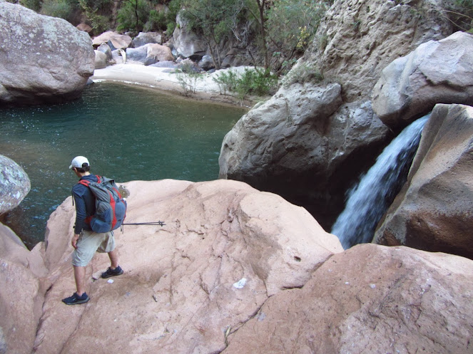
Waterfall | Tararecua Canyon
In such circumstances, politeness can sometimes be misconstrued as weakness. That being the case, the best defence is often a good offence. Thus without further adieu, I turned around, went straight up to the guy and in words not appropriate for this particular website, told him that he would be well advised to cease following us lest his precious green container be promptly inserted where the sun doesn’t shine. He realised from my tone that I wasn’t joking, but couldn’t resist sounding off with some hollow threats and a half-hearted shove. I responded spontaneously by giving him a swift boot up the backside. He gave a yelp and trotted off muttering under his breath.
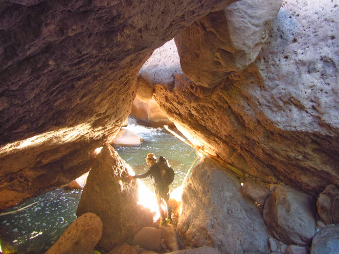
Justin Lichter | Tararecua Canyon
From that point on we weren’t too worried about our persistent friend. Our chosen route soon took us off the beaten path, and as a rule, junkies don’t generally make very good trackers. Later that night I couldn’t help but have a chuckle, as my parting shot reminded me of the classic “Simpsons” episode Bart Versus Australia…………just without the mooning and subsequent international incident!

Maps for the CCT
Justin and I used 1:50,000 INEGI maps for the CCT. They were the only topographic option available to us. For the type of technical terrain that we regularly encountered (e.g. pour-offs, narrow canyons, waterfalls), the relative lack of detail made it nigh on impossible to think too far ahead in terms of arrival times and/or route choices.
On numerous occasions, we were forced to alter our plans and bushwhack up and over certain areas or backtrack to navigable side canyons in order to progress. The unpredictability factor was turned up to eleven, thanks to the constant discrepancy between man-made features (e.g. paths, dirt roads, mines, cemeteries, etc.) we encountered on the ground and those that appeared on our topographical sheets. Indeed, villages seemed to materialise and disappear without rhyme or reason……………sort of like a Mexican version of Brigadoon.

Justin Lichter | Tararecua Canyon
River Deep, Canyon High: An Ode to Ike and Tina
In addition to the aforementioned cartographical challenges, perhaps our most regular obstacle during the CCT was that of historically high water levels. It turned out that the Copper Canyon area, one of the driest in Latin America, had experienced its biggest rainy season in 15 to 20 years. Whilst a blessing for local agriculture, both legal and otherwise, it was very much a double-edged sword in regards to our journey. On the one hand, it meant that the anticipated 6 to 8-litre water carries never eventuated. On the flip side, the abundance of precipitation translated to more time spent scouting out river crossings and floating stretches that we would otherwise have skirted around.
Cam Honan | Tararecua Canyon
Adaptability
One of my favourite wilderness expressions has long been: ¨Mother Nature doesn’t have a copy of your itinerary”. Never did these words ring truer than on the CCT. As alluded to above, there was not a day that passed when Justin and I didn’t have to make route changes on the fly. Adaptability was our mantra from start to finish.
Irrespective of one’s backcountry experience, when navigating through challenging cross country terrain, there will inevitably be times in which directional choices turn out to be incorrect. In these situations, no one likes the idea of backtracking. However, one of the differences between an old hand and a less experienced outdoors person is the ability to recognise when it’s time to retrace one’s steps and try again. In such scenarios, stubbornness and pride should always take a back seat to objectivity and a cool appraisal of what is, rather than what might be.

Cam Honan | Copper Canyon
The Long Climb & the Serendipitous Pickup Truck
The final day into Divisadero consisted of numerous chest-high fords, two river floats and 6,000 feet elevation gained. Approximately half of the aforementioned climbing was spent bushwhacking up cactus laden cliffs. In 12 hours of continuous hiking, we covered approximately 10 miles.

Bushwhack/Climb out of Urique Canyon to Divisadero.
For much of the day, I rambled on to Justin about how we would finish at 5 pm. Looking into my half-empty Gatorade bottle (the hiker equivalent of a crystal ball), I further opined that upon reaching our destination there would be a white pickup truck waiting to transport us directly to Creel, where we would subsequently arrive just in time for the 6.30 supper at Plaza Hotel Margarita’s (our base camp during the CCT). All the time Justin simply nodded his head; most likely thinking something along the lines of………… ‘dude, are you sure you haven’t been sampling the local peyote again?’

Climb out of Urique Canyon to Divisadero.
Well, believe it or not, we did finish right on 5 pm. Instead of a white pickup truck, there was a red one parked by the roadside. We sprinted, or at least hobbled rapidly, up to its owner and asked if he was headed to Creel. He answered in the affirmative. We promptly jumped in the back and were on our way (see final photo below). We arrived at the hotel at 6.10 pm, a full twenty minutes before dinner time. It was difficult to imagine a better ending to the day.
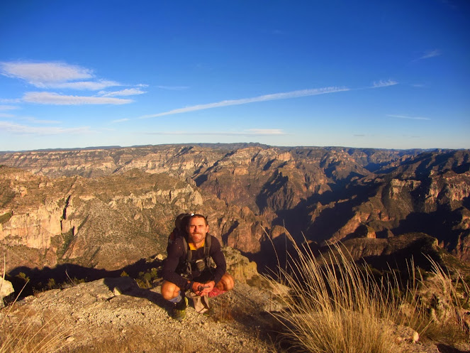
Cam Honan overlooking Urique and Copper Canyons.

Cam Honan & Justin Lichter
Related Posts
- CCT Stage 1 – Basaseachic Falls to Creel
- CCT Stage 3 – Divisadero to Batopilas
- CCT Stage 4 – Batopilas to Cumbres de Sinforosa
Discover more from The Hiking Life
Subscribe to get the latest posts sent to your email.
Yay for Adventures!
Yes-incredible guys. When my brother got us across the river to Barranca de Cobre, and we just walked up the regular “Camino Real”, as you probably realized the main trails are called by locals, equivalent to interstate highways for us, the walk up to Guaguachique and a nice stay with missionary Terry there (I traded him my 2 Mexican Army topos for 2 kilos of tortillas and a can of Spam, to get us 2 more days to Batopilas, via Cireneguita de la Barranca and Munerachic.