Mount Assiniboine is Canada’s answer to the Matterhorn. The tallest mountain in the southern Canadian Rockies, this striking pyramidal peak rises more than 500 m (1,640 ft) above its immediate neighbours. Viewing Assiniboine’s majestic reflection in the crystal clear waters of Lake Magog, rates as one of the highlights of the Great Divide Trail, a rugged backcountry route through the Canadian Rockies that ranks as one of North America’s most spectacular (and challenging) long-distance hikes.
I hiked the GDT in August 2011. It was the second of the 12 Long Walks, and immediately followed my completion of the Pacific Northwest Trail at Waterton Lake on the US/Canadian border.

Mount Assiniboine
At a Glance
Distance: 1200 km (750 mi) approx. Depends on where you start/finish in the north (see below)
Average Time: 40 to 50 days
Difficulty Level: Challenging
Highest Point: Unnamed pass above Michele Lakes at 2,590m (8,500 ft).
Lowest Point: Old Fort Point near Jasper at 1,055m (3,500 ft).
Start / Finish:
- Southern Terminus: Waterton Lake National Park, Alberta – US/Canadian border (southern terminus). Waterton Lake is also the northern terminus of the Continental Divide Trail and the original eastern terminus of the Pacific Northwest Trail.
- Northern Terminus: There are three options (from south to north): 1. Jasper – the original northern terminus (901 km / 560 mi approx.); 2. Mount Robson (1000 km / 620 mi approx), and; 3. Kakwa Lake (1200 km / 750 mi approx).

Great Divide Trail Overview Map (From GDTA website)
Season:
- Mid-July to mid-September.
Getting There & Away:
See the GDTA Access page for the up-to-date information on accessing the southern and northern terminii. In summary:
- Southern Terminus: Waterton Lake is serviced by shuttle buses from Glacier National Park in the United States. From Calgary, there is no regular public transport services to Waterton, although it is possible to charter shuttles.
- Northern Terminus: 1. Jasper – serviced by regular bus or train services; 2. Mount Robson – No public transport options, but usually an easy hitch back to Jasper, and; 3. Kakwa – the transportation wildcard. From the infrequently visited lake terminus, it’s a further 75 km (40 mi) along a little-used Forest Service road to Highway 16. From there you will need to try your luck hitching south on Highway 16 to either McBride or all the way to Jasper. A DCF rabbit’s foot or shamrock may be a good idea.

International border post on Waterton Lake – the southern terminus of the GDT.

Reflections at day’s end / Waterton Lakes National Park.
Maps and Information
- Great Divide Trail Association (GDTA) Website: Excellent site run by the stewards of the trail. Trip planning resources, hiker forum, map recommendations, permit details, trail journals, photo galleries, travel information, and more. In fact, who am I kidding, if I was you I’d disregard the rest of this summary and go there immediately.
- Maps: Ryan Silk GDT Map Atlas (2017) – A free 87-page map set at 1:50,000 scale covering the entire trail.
- Overall Map Resource: The Trip Planning Resources / Maps section of the GDTA website has a good overview of the current map options available for the trail.

Mesmerizing views from the Divide.
- GDT App: Atlas Guides (Guthook) GDT App for either Android or IOS.
- Guidebook: Dustin Lynx, Hiking Canada’s Great Divide Trail (2018 – 3rd Edition): Contains trekking notes, sketch maps, town, and resupply information.
- All the Latest: GDTA Hiker Notes: Up-to-date resource containing route notes from recent GDT hikers. The site is curated by the Great Divide Trail Association.
- Websites: Paul “Mags” Magnanti, Quick and Dirty Guide to the GDT

Peter Lougheed Provincial Park
- Permits – Hikers will require a general parks pass and backcountry permits for camping in all national parks and some provincial parks. In regard to the former, it’s called a Parks Canada Discovery Pass, it covers entry into Canadian National Parks, and it’s easily obtainable online. As for the latter……..not so simple. See the GDTA Permits page and the always pragmatic Pmags.com for details and suggestions on negotiating the Canadian backcountry camping permit system from a thru-hiker’s perspective.
- Resupply: See the Resupplying page on the GDTA website for a comprehensive summary of options.
- History of the GDT: At the time of writing in April 2020, the GDT is still flying under much of the backpacking world’s radar. A big part of its relative anonymity can be found in its stop-start history. The idea for a path along Canada’s Great Divide was first proposed by the Girl Guides in the 1960s. At the beginning of the following decade, Parks Canada gave the project an official green light, with the goal of completing the trail by 1975. However, more than four decades and quite a few bureaucratic hiccups later, the GDT remains a work in progress (see Route / Conditions below). See the GDTA History page for an in-depth look at the trail’s past.

Route / Conditions
As of 2020, the GDT is actually more of a backcountry route than a pathway. Consisting of a combination of cross country travel, pre-existing trails (some maintained, others not so much) and the occasional stretch along remote dirt roads. With the exception of some of the National and Provincial park sections, for the most part the way is unmarked. Good navigation and route finding skills are a must.
- Provinces, Parks, and Wilderness Areas: Geographically speaking, the Great Divide Trail picks up where the Continental Divide Trail (CDT) leaves off at the US/Canadian border. It winds its way northwest along the Canadian Rockies, passing through two provinces (Alberta and British Columbia), five National Parks (Waterton, Yoho, Kootenay, Banff and Jasper), nine Provincial Parks and four designated wilderness areas.
- Scenery and Challenges: During its course the GDT it weaves back and forth between the provinces of Alberta and British Columbia, treating the hiker to a continuous course of glacier-carved valleys, glistening mountain lakes, and jagged granite peaks. From start to finish it is an Alpine Tour de Force. There are challenging river fords, long stretches of overgrown terrain, unpredictable mountain weather and a diverse range of fauna.
- Wildlife: Hikers may encounter moose, elk, bighorn sheep, bobcats and, of course, the one that everyone both wants to see and doesn’t want to see, grizzly bears. If you’ve been searching for a hike with abundant wildlife viewing opportunities, look no further.
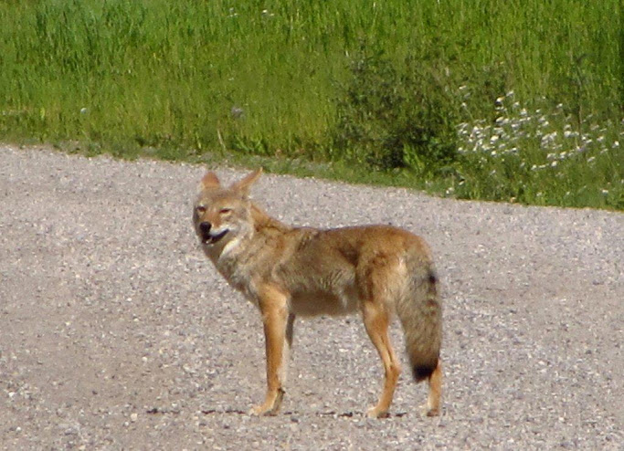
Coyote at Peter Lougheed Provincial Park.

Grizzly at dusk | Banff National Park
Highlights – Waterton to Banff
- Waterton Lakes National Park: The park’s namesake lake and its dramatic mountain backdrop makes for a memorable beginning (or end) to the journey.
- La Coulotte Ridge: Some of the toughest, most rewarding hiking of the entire GDT.
- Kananaskis Lakes at sunset. The sublime views were only slightly tempered by an afternoon encounter of the bruin-kind.
- Mount Assiniboine: Matterhorn-like peak (see photo above) which is best seen in the early morning from the eastern end of Lake Magog.
- Safe Haven B&B: The place to stay in Coleman. Three meals. Comfy rooms. Hospitality plus. Alannah and Dan are the GDT’s number one trail angels……………actually, in 2011 they were the only trail angels. Nonetheless, this was my favourite town stop during the GDT.
- Bear Street Tavern Pizza: Even if you are not resupplying in Banff, it is worth the trip in just for this pizza.

La Coulotte Ridge


Kananaskis Lakes at sunset.
Highlights – Banff to Jasper
- Banff, Kootenay and Jasper National Parks were uniformly incredible. Specific areas that come to mind are Whistling Pass, the Rockwall trail and Jonas Shoulder. There were many other equally stunning locales, but when you are hiking in driving rain/snow and it’s colder than a witch’s titty during a Siberian winter, you do not always appreciate the aesthetics as much you should.
- Climbing up and over Cataract Pass in whiteout conditions provided some of the toughest, but most satisfying hiking of the GDT. Similar weather was encountered going over The Notch, but as that section is part of the well-trodden Skyline Trail, navigation was not so much of an issue.

The Rockwall | Kootenay National Park

Hiking through a snowstorm along Cataract Creek.


Snowy conditions on the Skyline Trail | Jasper National Park
Final Thoughts
If you were to choose just one word to describe Canada’s Great Divide Trail, that word might be “Big.” Big mountains, big rivers, big distances, big animals, big lakes and big storms. Everything’s big……….with the exception of the amount of people that hike it. However, the winds of change have begun to blow. Thru-hiking numbers are gradually increasing. The Great Divide Trail Association, which was reformed in 2013, has been making positive strides towards official recognition from provincial governments. To cut a long story short, the GDT’s days of relative anonymity appear to be coming to an end. The time to hike it is now.
Discover more from The Hiking Life
Subscribe to get the latest posts sent to your email.