The Salar de Uyuni is the earth’s largest salt flat. Situated in the southwest corner of Bolivia’s Altiplano, it measures a staggering 12,106 sq km (4,674 sq mi); more than 20 times bigger than Death Valley. It is an otherworldly sight to behold, a glistening ocean of white salt crystals stretching out as far as the eyes can see to the bluest of blue horizons. For fit and well prepared hikers who have prior experience backpacking in arid environments, it is possible to walk across this unforgiving expanse, and in so doing complete one of the world’s most unique hiking journeys.

(Note: I hiked across Bolivia’s Salar de Uyuni in August, 2017, as part of a longer 373 mile (600 km) route I put together through Bolivia’s Altiplano region. This north to south trek started at the village of Coipasa and finished at the Bolivia/Chile border on the summit of Volcan Licancabur (5920 m / 19,423 ft)).
At a Glance
Distance: 82 km (51 mi)
Duration: 2 days
Level: Moderate to challenging
Start / Finish:
- Northern Terminus – Tahua or Coquesa
- Southern Terminus – Chuvica
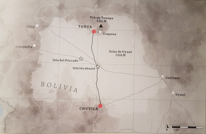
Overview Map of the Salar de Uyuni Crossing. This map is from my recent book with Gestalten publications, “The Hidden Tracks: Wanderlust Off the Beaten Path.” The book features 29 incredible hikes from around the world, including the Salar de Uyuni Traverse, the Hayduke Trail, and a loop around Lapland’s Sarek National Park.
Altitude:
- 3,656 m (11,995 ft). With an altitudinal variation of less than one meter, the Salar de Uyuni is the flattest place on the planet.
Season:
- The dry season of June to September (i.e. southern hemisphere winter) is ideal. Note that it can be on the nippy side; temps of -20°C (-4°F) are not uncommon.
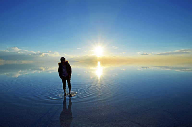
- Try to avoid hiking during the rainy season between December and March. In this period the Salar transforms into the world’s biggest infinity pool; wonderful for reflection shots, not so good for hiking. The thin film of water covering its surface makes progress slower, afternoon electrical storms are common, and stopping for a break becomes a difficult proposition —- unless you feel like sitting in salt water while you eat your breakfast or lunch.
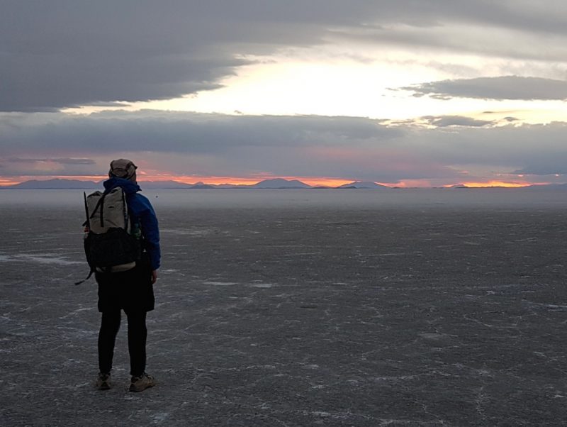
Day 2 – Isla Incahuasi to Chuvica.
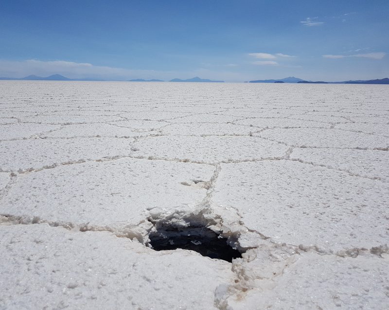
Watch your step | One of the many “ojos de agua” (eyes of water) that can be found while crossing the Salar.
Logistical Information
Getting There & Away:
- Southern Terminus – No problems getting to and from the southern terminus of Chuvica, which has a daily bus service to Uyuni (the regional hub). In 2017, the bus was leaving Chuvica at around 6.45 am. Best not take this departure time to literally; ask about the current timetable upon arrival.
- Northern Terminus – The villages of Tahua and Coquesa aren’t so simple to access, as there are no public transport options currently available (as of April, 2019). That said, it shouldn’t be too difficult to convince one of the multitude of Uyuni-based tour operators to take you to one of the northern terminii, which are often included on their Salar de Uyuni 4WD itineraries. Alternatively, you could work out a price with a local taxi driver. The journey will take around 1.5 to 2.5 hrs one way from Uyuni to Tahua/Coquesa, and I suspect you could organise it for less than US$50.
“Downtown” Coquesa.
Resupply & Water:
- Coquesa has a grocery store where you can purchase provisions for the hike. Chuvica also has a store in case you prefer to hike from south to north. Alternatively, you can buy everything you need in Uyuni before arriving at the trailhead.
- During the hike, the only option for food and water is Isla Incahuasi. This cactus-laden island has a restaurant as well as a small store, where it is possible to purchase snacks, basic meals, and most importantly, replenish your H2O supplies.
Sunrise from the summit of the Isla Incahuasi.
Sunset from the edge of the Isla Incahuasi.
Accommodation:
- Northern Terminus – I stayed in Coquesa, in an affordable no-name pension across the sandy street from Mayal Hostal de Sal. There are a handful of other simple accommodation options in the village. If you are looking for a bit more in the way of luxury, try the Hotel Takya de Sal in nearby Tahua.
- Isla Incahuasi. As of 2019, no camping is permitted on the island. However, hikers and cyclists are allowed to stay in the “hostel”, which is actually just a hall with some chairs and tables. No bedding is available, so you will need to bring your own sleeping bag and pad. There are no shower facilities, but there is electricity, so it’s possible to charge your electronic devices if necessary.
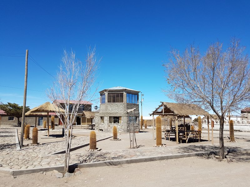
- Southern Terminus – There are various “salt hotels” available in Chuvica. Unlike the fancier Takya Hotels, these places won’t set you back more than US$10 to 20. All of the establishments serve meals.
- Can I camp on the Salar?: Camping on the salt flats is discouraged. Unless you have a free-standing shelter getting your tent pegs is difficult due to the rock hard terrain, and if the wind picks up during the evening you could be in for an uncomfortable time. However, the principal reason not to camp on the Salar is environmental. There is nowhere to go for a #2 as digging cat holes is not possible (see tent pegs), and even though I’d hope most folks considering this hike would practice LNT principles and pack out their poop, the reality is that many tourists do not, and the Salar already faces considerable challenges with the 4WD tour groups being careless with their trash.
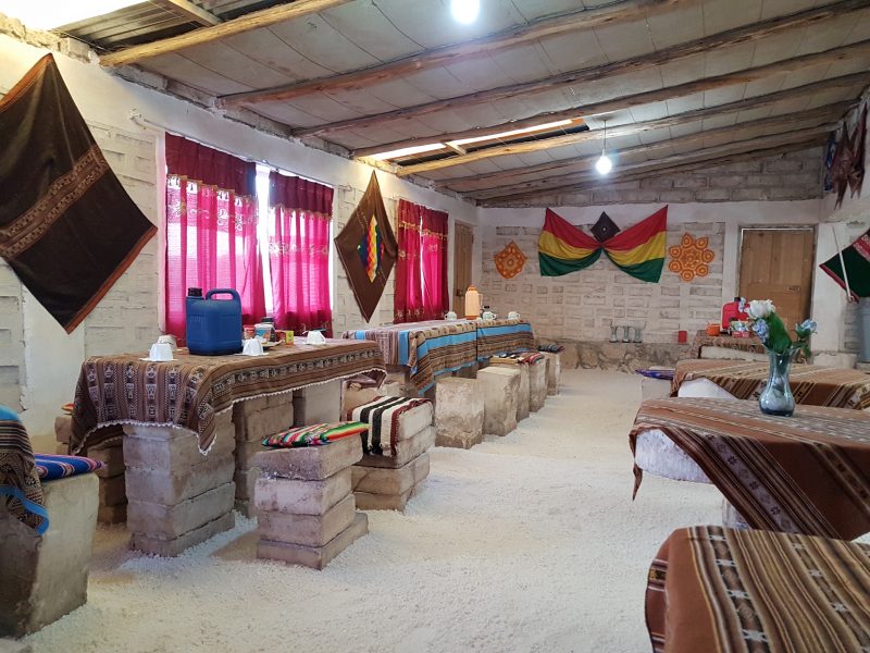
Salt hotel in Chuvica. In these unique establishments, the walls, floor and furniture are all made of salt.
Background Information
How was the Salar de Uyuni formed?:
In its current manifestation, the Salar de Uyuni was formed approximately 12,000 years ago as a result of the sequential transformation of two prehistoric lakes, namely Minchin and Tauca. When the waters of the latter evaporated, the salt deposits that leached from the surrounding mountains took shape in the form of two vast salt deserts – the Salar de Uyuni and its smaller cousin to the north, the the Salar de Coipasa.
Before it dried up, Lake Tauca was said to have a depth of approximately 100 meters (328 ft). Nowadays, during the annual rainy season between December and March, its direct descendant – the Salar de Uyuni – fills with 15 to 50 cm (6 to 20 in) of H2O. At this time of year, the area transforms into the world’s largest natural mirror; a surreal sight in which the earth and sky merge to form a singular, dream-like landscape.
Salar de Uyuni during rainy season (Photo from Wikimedia Commons)

Salar de Uyuni during dry season.
Lithium :
Lithium is the world’s lightest metal, and is used to power our smartphones, laptops, and other digital devices. According to estimates, the Salar de Uyuni holds between 50 and 70 percent of the world’s supply beneath its glistening white surface.
Flora & Fauna:
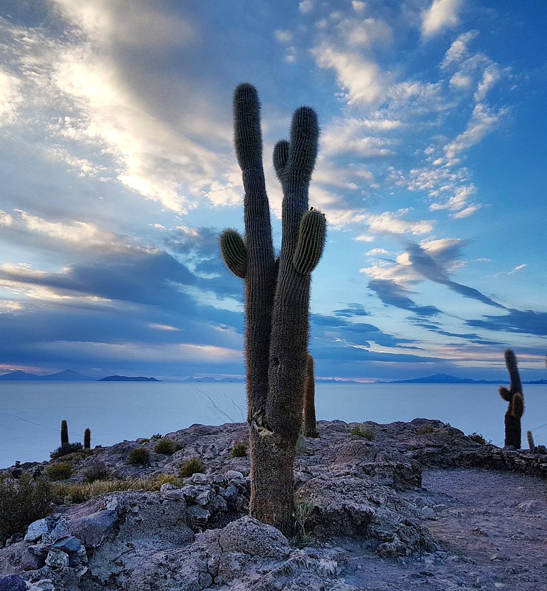
There isn’t much in the way of flora on the Salar de Uyuni. The notable exception to this rule being the giant cacti (Trichocereus pasacana) of the Isla Incahuasi. These plants can be found at altitudes between 2,000 m (6,562 ft) and 4,000 m (13,123 ft). They, grow up to 10 m (33 ft) in height, and are endemic to the Andean regions of Bolivia, Argentina, and Chile.
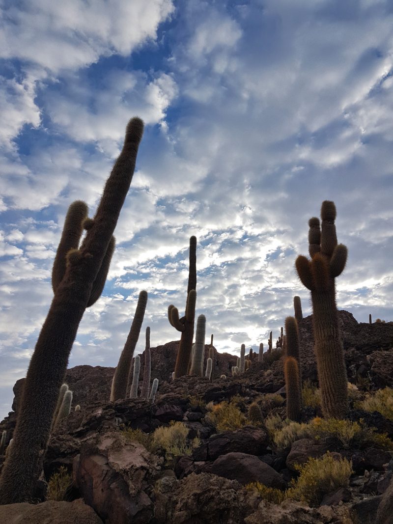
The Trichocereus Pasacana of Isla Incahuasi.
Route Information
Description:
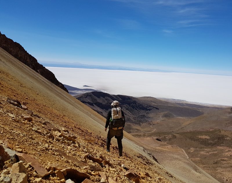
- Trailheads – Going from north to south, the trek begins at either the village of Coquesa or Tahua and finishes at Chuvica. I opted to start at Coquesa because it was easier to access after the descent of Volcan Tunupa. It also has more accommodation options and a better resupply selection at the general store on the plaza
- Terrain: The salt crystals are rock hard underfoot and the terrain is pancake flat. Watch out for the occasional hole in the surface, known as “ojos de agua” (holes in the water).
- Distance & Time – The route is approximately 82 km (51 mi) in length, takes two days to complete, and consists of two stages which are are roughly equal in distance. Each segment will take between seven and eleven hours.
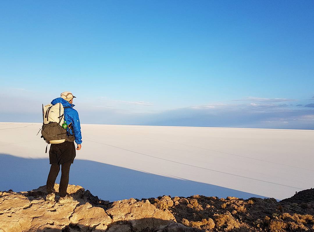
Gazing out from the Isla Incahuasi overlooking the Salar. On this particular trek, I carried the Hyperlite Mountain Gear Southwest 2400 backpack.
- Navigation – Hikers should carry a GPS and/or map and compass, as there is little in the way of landmarks, and it is easy to become disorientated in the middle of so much nothingness.
- H2O – Carry at least four to six liters of water per stage. Except for Isla Incahuasi there is nowhere to obtain water during the route.
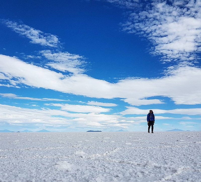
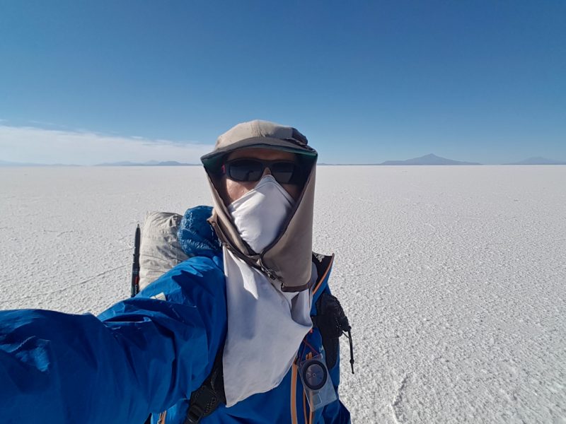
- Weather – Strong winds are common, and day time temps in the winter normally hover just above freezing. During the evenings it regularly drops down to between -10° and -20°C (14°F and -4°F).
- Gear Tips: Polarized sunglasses, face protection for the winds, puffy jacket, wind shirt/rain jacket, wind pants, sunscreen, thermal underwear, four to eight liters water capacity, beanie, compass, mittens, sleeping mat and a quilt/sleeping bag that is accurately rated to at least 15°F (-9°C).
Layered up on the Salar de Uyuni.
Avoid the Crowds:
On the Salar de Uyuni nearly all tourist vehicles use the same 4WD roads. In order to avoid the traffic (assuming a southbound hike), at the beginning of both stages simply head in a southwest direction for around 300 m (984 ft). By that point, any vehicles in your vicinity will be specs in the distance. Once you are far enough away from the 4WD road, take a directional bearing and head towards your destination in blissful solitude.
Under the Night Sky
In recent years the Isla Incahuasi has become one of the main attractions on 4WD tours of Bolivia’s Altiplano. When you arrive at the island in the late afternoon, expect to be accompanied by scores of tourists who have come to watch the sunset. It makes for a stark contrast to the solitude of the day’s hike. However, once the sun goes down and the tourists depart, with the exception of the island’s caretakers, chances are you will have the entire place to yourself. After eating dinner and settling in, consider taking a nighttime stroll on one of the island’s well-maintained pathways. Gazing out from your hilltop perch, the cactus stand silhouetted against the moon, and the gentle light softly illuminates the ethereal white sea that surrounds you. As far as once-in-a-lifetime experiences go, they don’t come much more enchanting.
Why did I hike from North to South, rather than west to east?
I hiked from north to south across the Salar, because that was the direction I took on the longer Altiplano Traverse (see below for links). It also afforded me the opportunity to ascend Volcan Tunupa (5321 m / 17,457 ft), which is situated on the Salar’s northern boundary. The views from the massive volcano were among the best of the entire trip.
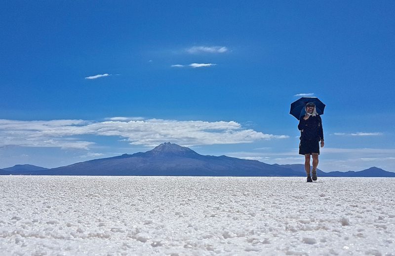
Day 1 – Yours truly under my Montbell Sun Block umbrella crossing the Salar de Uyuni. That’s Volcan Tunupa in the background.
Yours truly overlooking the World’s largest salt flat from the flanks of the Volcan Tunupa.
Related Articles:
- Altiplano Traverse (Stage 1) – Salt Flats, Volcanoes & Quinoa
- Altiplano Traverse (Stage 2) – Coloured Lakes, Geothermal Fields and a Towering Finale
- Gear List: Altiplano Traverse
Discover more from The Hiking Life
Subscribe to get the latest posts sent to your email.
Amazing, Intriguing but also concerning. Beautiful in a very different way.
What a wonderful opportunity you have been given. Thank you for sharing it. I consider how life delves out to each of us our own unique circumstances. Yours in this is full of wonder, yet for me, well, I can dream & being an optimistic person, do what I can to undertake those adventures which are within my own realms of possibilities…
Thank you, for you add to the bank of inspiration I hold in my heart…
Wow. What a hike! Can’t wait to read more about Bolivia’s Altiplano region. The photography is stunning.
Very, very different terrain then I have seen b4. What an interesting place. Thanks for the great pictures.
Land I can afford.
thanks Cam, I´ve been waiting anxiously for this post! If you ever fancy coming to Brazil let me know!
Thanks for your patience!
the life you have chosen is spectacular in so many ways. Thanks for letting me see all the places you get to and the work you have to do to enjoy them. It is eye-opening in so many senses of that phrase 🙂
I was already planning on going to Bolivia for a while now and your blog really helped me decide to do this trek. Your recommendations and advice made the trip there for me by far easier. I booked it with Gulliver Expeditions (www.gulliver.com.ec) and it was an amazing once in a lifetime experience.
I’m looking forward to reading about and discovering more places like this.
Amazing! Super looking forward to your longer altiplano report. I’m currently in a phase of life where I can’t do 5 month hikes so looking for a lil smaller ones to fill my adventure niche. Did DM do this one with you? I thought I read about him doing something similar.
Hey Dizzy,
Thanks for the kind words. On that particular trip DM had joined me on a couple of hikes in Peru and the Cordillera Real Traverse in Bolivia. He was all set to do the Altiplano route as well, but I had some back issues I was dealing with and had to postpone the trip for a couple of weeks. Unfortunately, DM couldn’t wait around because of commitments up in the States. It was a bummer, because it would have been great to do the route together. However, being the persistent bloke that he is, DM returned to Bolivia the following year to do the hike.
Cheers,
Cam
Hi there,
We did the traverse a few days ago and your detailed description helped us a lot. Thanks for that!
A few updates for future adventurers:
There is a colectivo that goes from Uyuni to Coqueza every day at 3 pm for 30 bs. as far as we know.
The Refugio on the island was pretty dirty when we were there, so we slept in our tent.
In Chuvica the bus only goes to Uyuni on Thursdays and Fridays at 7 am. It’s better to go to Tanil Vinto where the bus leaves every day at 7 am and on Mondays also at 2 pm.
Thanks again!
Greetings from Germany 🙂
Hi Paula,
Well done and thank you for the updates!
Cheers,
Cam
Hey Paula,
I have many questions because I want to hike trough the Salar de Uyuni with my tent. 😀 Is there any chance I could get in touch with you?
Kind regards
Juran
Hey Juran,
of course! Just send me a mail to: plaaazis@gmail.com