One of Europe’s last true wilderness areas, Sarek National Park is situated north of the Arctic Circle in Swedish Lapland. It’s one of those places where everything seems to be big – valleys, glaciers, mountains, rivers and animals (e.g. bears, moose and lots of reindeer). Established in 1909, Sarek was one of Sweden’s first designated National Parks, and due to its remote and largely trail-less nature, it has remained the province of experienced hikers, climbers and cross country skiers ever since. I put together the hike described below in 2009, as part of a longer 140 mile (225 km) route that combined Sarek, with the northern section of the Kungsleden. All information has been updated as of June, 2018.
Distance : 68 miles (109 km) approx.
Avg.Time : 5 to 7 days
Start / Finish :
- Akka – Saltoluokta
- I combined this route with the scenic northern section of the Kungsleden, which starts in Abisko and finishes in Vakkotavare. Together they made for a fantastic 225 km (140 miles) hike through some of the most beautiful wilderness in Lapland.
- From Vakkotavare, you can catch a bus to Ritsem (33 km WNW – Bus #93, which originates in Gallivare), from where you take a short ferry ride over to Akka.
- From the finish in Saltoluokta there are regular ferries to Kebnats, where connecting buses (once again #93) will be waiting to take you to Gallivare.
Season / Conditions :
- Late June to September. Sarek is known as one of the stormiest areas in Sweden. The unpredictable weather combined with the lack of shelters and trailless nature of the terrain, means that it is not a place you want to be without sufficient warm layers and good rain gear. As one of Sweden’s most famous proverbs says: “Det finns inget dåligt väder, bara dåliga kläder” (in English – “there is no bad weather, there are only bad clothes”). For those wanting to experience similar arctic landscapes to those which are found in Sarek but aren’t sure they possess the necessary experience with which to do so, the Kungsleden (King’s Way) represents an excellent alternative.

Maps / Info :
- BD10 1:100,000 Sareks National Park: In 2009 I was unable to find much in the way of information for Sarek, however, the BD10 topo more than sufficed for navigation purposes. If you are proficient with map and compass, this should be all that you need.
- Online Information: Check out the Sarek National Park page at Wikiwand.com for an informative overview of the area’s geography, climate, wildlife and history. For more hiking-specific information, including different route options in the park, see the following sites : 1. Backpacking North – Views from Sarek; 2. Hiking Sarek: An Englishman’s Guide.
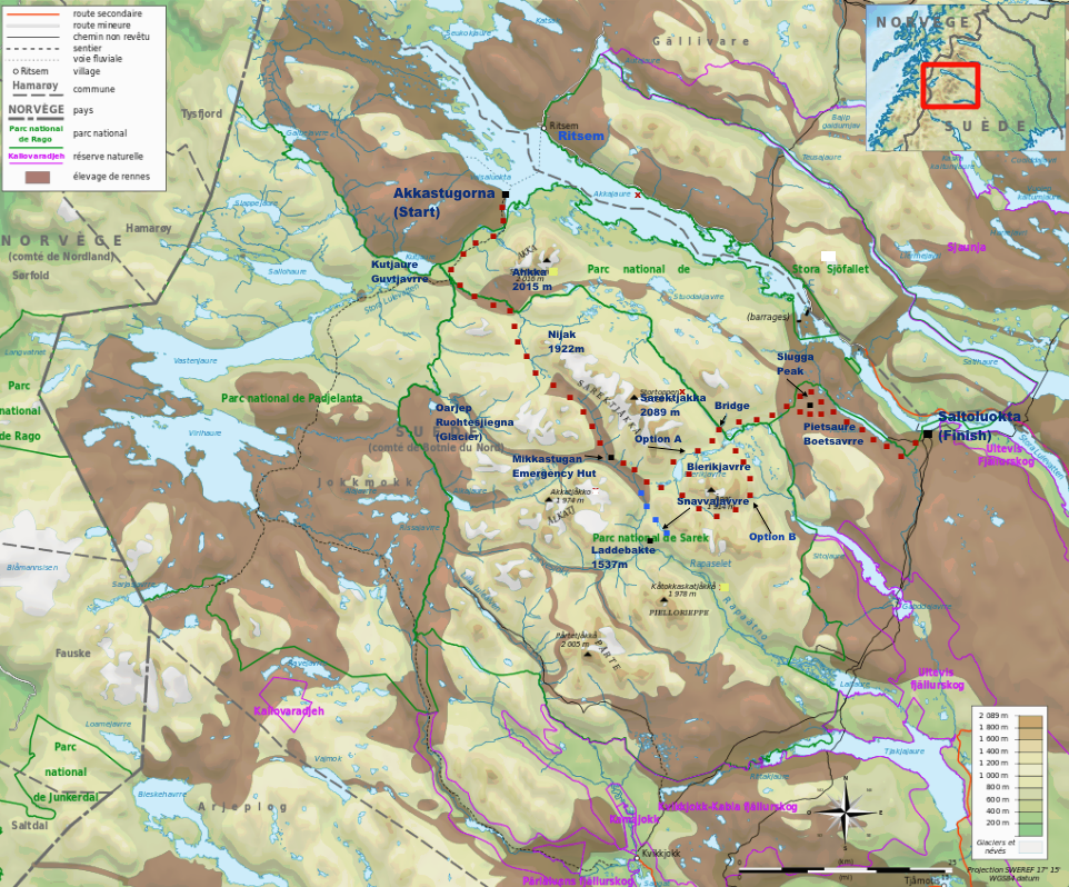
Overview map of my route through Sarek NP.

Photo from wikiwand.com.
- Water: Plentiful. If memory serves, I never carried more than one litre at a time. I didn’t treat any of my H2O and had no intestinal issues.
- Food: All supplies should be brought from Gallivare or Kiruna. If you are linking this hike up with the Northern Kungsleden, there is a small shop in Ritsem where it may be possible to resupply (Note: Choices are limited and expensive).
- Fauna: Amazing variety of wildlife including Europe’s largest moose, bears, wolverine, lynx and golden eagles. Loads of reindeer. (Fun Fact: Sweden has more moose per square kilometer than any other country in the world, with a total population of around 400,000).
- Terrain: Much of Sarek National Park is trail-less and boggy. With its long valleys, rivers, glaciers and distinctive peaks, navigation is not overly difficult when conditions are fine. However, when the weather turns nasty, Sarek is not the place you want to be without good backcountry skills and the right equipment. (e.g. During the last one-and-a-half days of my hike, I spent 90% of my time trudging through driving wind, rain and fog. The temperature hovered between 2° and 5° celsius and visibility was rarely more than 50 metres).

Origins of Sarek NP: The Yellowstone region of Wyoming, Montana and Idaho was declared the world’s first national park by the US government in 1872. Inspired by this landmark conservation decision, Swedish Explorer Adolf Erik Nordenskiöld proposed an equivalent type of protection for his own country’s abundant wilderness areas in 1880. Almost three decades later in 1909, the proposition was finally adopted, and Sarek along with eight other natural areas in Sweden were declared Europe’s first national parks.
Route :
- Described below is the route I hiked in August, 2009. All grid references are taken from the above mentioned BD10 topographic map.
- Starting from the jetty in Akka (Swedish Grid Ref or SGR: E156613 N750539), head south for approximately 3km before crossing the Vuojatadno on a footbridge.
- Linking up with the Padjelantaleden, continue SW on a clear trail for another 9km until you reach the border of Sarek National Park (SGR: E 155970 N 749690).
- From this point, head ESE along the true left side of the Sjnjuvtjudisjahka (river).


- Once you reach the dilapidated Kisuriskatan hut (SGR: E156741 N749353), head SSE for about six kilometres before reaching Nijakjagas (lake).
- From the lake continue SE, passing the Sami hut of Renvaktarstuga, before entering Ruohtesvagge valley.
- Continuing along the valley, you will eventually reach the emergency hut of Mikkastugan (SGR: E157888 N747693).
- Immediately after the hut, cross a footbridge, and continue SE on the true right side of the Rahpajahka.


- About six kilometres after the emergency hut, cross the Bielajahka river. From here I decided to head south and complete an out-and-back side trip to Laddebakte peak (1537 m) via Spokstenen (663m) and Snavvajavvre lake (977m – SGR: E158510 N746850). In clear weather, I imagine the panorama from the summit would be amazing. In crappy conditions, I still recommend heading up as far as Spokstenen for some great views.
- Back at the Bielajahka river, you have two options, both of which are good. Option A is to head east, and then north past Bierikjavrre lake. From the northern tip of Bienkjavrre, continue ENE passing a series of lakes and a large footbridge over the Guhkesvakkjahka (river) (SGR: E 159190 N 748080), eventually reaching the distinctive (in fine weather) Slugga peak (1279m). Option B (which is longer) is to go ESE from the Bielajahka river along Alep Basstajanka. Follow this all the way around Ahpar, linking up with the Lulep Batajahka. Once you emerge into the open valley a few Km NW of Sitojaure, head north again to link back up to the Option A route close to Stuovarre peak (1089m). From there head NE towards Slugga.
- Once you have passed Slugga peak, continue SE along the southern side of Pietsaure (Bietsavrre) lake, wade cross the Avtsusjjahka (river) and finally head NE to the lakeside lodge of Saltoluokta (SGR: E161648 N748021). Try to arrive in time for the buffet lunch!


Sleeping :
- Bring a tent. If tarping, a bug canopy is necessary. There is an emergency shelter at Mikkastugan.
Overview :
- With almost no paths or signs and little in the way of tourist infrastructure, Sarek is to Swedes what Alaska is to Americans – a raw and untamed land in which dreams of outdoor adventures can be realized.
- Sarek provides the solitude that is absent on the Northern Kungsleden. During my five days in the Park I didn’t see a single other hiker. Incredible scenery throughout. It’s a place I would love to return to in the future.


Discover more from The Hiking Life
Subscribe to get the latest posts sent to your email.