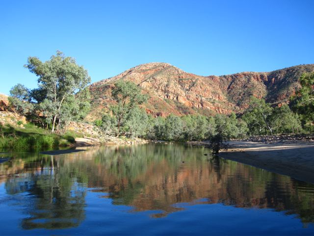
Situated in the heart of Northern Territory’s Outback, the Larapinta Trail is one of Australia’s premier long distance hikes.

Counts Point at sunset.
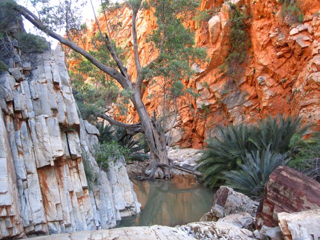
Winding its way some 231 km along the incredible West MacDonnell ranges, it traverses ridges and plains, and passes through some of the most amazing gorges in the country.
I hiked the Larapinta Trail in 2010. All information has been updated as of January, 2016.
Distance : 143.5 miles (231 km)
Avg. Time : 13 – 15 days
Start / Finish :
- Redbank Gorge – Telegraph Station.
- In regards to walking direction, I don’t think it makes a difference which way you go. From a logistical/transport perspective, it’s easier to hike west to east, thereby finishing your journey at Telegraph Station, just a few kilometres away from downtown Alice Springs.

Larapinta Trail / MacDonnell Ranges Overview Map (from www.macdonnellranges.com)
Transport:
- No public transport available to Redbank Gorge (156 km west of Alice Springs). Your options are either hitching or private shuttles (e.g. Larapinta Transfers). For details of other operators, contact the Tourism Australia Visitor Centre in Alice Springs.
- An alternative to private shuttles (which can be expensive if you are hiking solo), is taking one of the multiple daily tours from Alice Springs to Glen Helen Resort, which is situated about 25 km away from Redbank Gorge. These tours generally make stops at a couple of the places where you can leave food drops (e.g. Ellery Creek and Ormiston Gorge – See below for more details). The tours cost approximately $100. Once at Glen Helen, you can either hitch, walk or get a ride with someone from the resort the rest of the way to Redbank.


Season :
- April to September is ideal. October isn’t bad either if you don’t mind a bit of heat. I did the Larapinta Trail in mid-October, 2010, and apart from a couple of days in the low-30’s celsius, the temperatures weren’t too uncomfortable. An added bonus was that I didn’t encounter a single other thru-hiker during the entire trip. Avoid summer when the temperatures can be scorching. Think the surface of the sun…………yep, that’s about it.

Maps / Info :
- I used the maps and trekking notes in John Chapman’s, Larapinta Trail. This informative guidebook also contains a general overview of the area’s history, geology, flora and fauna. An alternative to Chapman’s guide is the Larapinta Trail Package, available from the Northern Territory Parks & Wildlife Commission.
- For up-to-date online information regarding the Larapinta trail (e.g. food drops, water, current trail conditions and section maps) try Larapintatrail.com.au or the Northern Territory Government Parks and Wildlife website.
Resupply
- Provisions for the hike can be bought in Alice Springs. If you’re not keen on carrying all of your food in one long haul from start to finish, there are two official storage points at which you can leave resupply boxes – Ellery Creek and Ormiston Gorge.
- Resupply drop-offs can be organised in advance with one of the private shuttle companies (each drop-off costs extra). Alternatively you can take one of the tours I mentioned above and do them yourself for the same price. Either way, you’ll need to pick up a key from the Tourism Australia Visitor’s Centre in Alice Springs in order to access the resupply storage rooms at both of the above mentioned facilities.
- Supplemental provisions can be purchased at the kiosks at Stanley Chasm and Ormiston Gorge.
- For an overview of resupply information, see the Food Considerations page on the excellent Larapintatrail.com.au website.

Route / Conditions :
- The Larapinta Trail is well marked and easy to follow from start to finish.
- Whilst navigation is not overly difficult, the terrain is at times challenging. Very rocky under foot, the trail is occasionally overgrown with spinifex; gaiters or hiking pants are recommended.
- On the fauna front, there are dingoes, wallabies and a myriad of reptiles and birds. Take particular care when walking through overgrown sections of trail. King Brown (or Mulga) snakes are not uncommon, however the only time they are likely to be a problem is if you actually step on one. Don’t worry too much; just watch where you walk! See Snakes in the HEALTH & SAFETY section for details.


- Drinking water is available at most of the designated campsites. These water tanks are maintained by Northern Territory Parks & Wildlife Rangers.
- Officially speaking it is recommended to treat all water. Unofficially, locals will tell you there is no problem drinking the water as is. I didn’t purify a single time and had no problems.
- Depending on recent precipitation levels, good drinking water can sometimes be obtained at certain creeks along the trail. However, this is by no means a given, and it is advisable to carry all that you need from the last reliable water source. The centre of Australia is not a place where you want to be dehydrated. Before setting out, check with NT Parks and Wildlife in regards to current water conditions.


- There is a dearth of shade along most of the trail. Broad spectrum sunscreen and a wide-brimmed hat (or umbrella) are essential kit, irrespective of the season in which you are hiking.
Sleeping :
- Camping is possible along the entire trail. Most of the designated campsites have rainwater tanks.
- If possible, don’t miss spending the night on Brinkley’s Bluff and Counts Point. Both provide magical panoramas. Just remember to bring enough water as neither has reliable sources close by.
Overview :
- The Larapinta Trail is one of my favourite Australian hikes. Visually stunning from start to finish. Amazing variety of flora, fauna and geological features. Highly recommended.
- Dining on the Larapinta : See below for a short recap of my most memorable meal on the Larapinta Trail, which involved a local ‘delicacy’, red wine and German-style baked goods.


Witchetty Grubs for Dinner
Witchetty grubs are wood-eating white larvae that are found in central Australia. They can be eaten either raw or cooked and are a traditional staple of the Aboriginal diet.
I was introduced to this ‘bush tucker delicacy’ on the Larapinta Trail courtesy of Don and Jules, two amateur botanists from Melbourne. My new found friends were doing an overnight trip in the MacDonnell Ranges. Pack weight was apparently not an issue; they carried in two bottles of wine, cheese, German-style bread and a cooking set-up that would not look out of place on MasterChef.
All of these things convinced me that Don and Jules were no culinary novices. They had tried witchetty grubs before and had come prepared. The grubs were merely an appetizer. We ate them raw.
How were they? A little like a mixture of raw eggs and nuts. When washed down by a couple of glasses of Bin 555 Shiraz, they actually tasted pretty good. 😉
Discover more from The Hiking Life
Subscribe to get the latest posts sent to your email.
Love to do it one day:)
Could you possibly post more detailed guide about LT?
Cheers
Ania
It’s a beautiful hike, I’m sure you’ll enjoy it.
In regards to a more detailed guide, see if you can pick up Chapman’s “Larapinta Trail” book. Lots of useful information!
Cheers,
Cam
Very thorough account of the hike 🙂 –which is quite helpful. The note on the “witchetty grubs” made me chuckle. Where’s the fun in hiking without moments like these?
Thanks for the kind words. The unexpected feast was definitely one of the highlights of the hike!
Cheers,
Cam
As for food drops you can utilize Stanley Chasm, (where they serve meals, and snacks. Also Glen Helen resort serves as a food drop depot.
As for not seeing other hikers, is that a plus? I met some great people out on the trail many of them from other countries
Thanks for the reminder about Stanley Chasm. In regards to your other question/point, certain folks like solitude, others enjoy meeting lots of hikers, many are in between. Sometimes it varies from hike to hike.
Cool to hear you met some great people. As I alluded to, on that particular trip I didn’t run into any other thru-hikers, but I did meet a handful of folks doing sections.
Cheers,
Cam
Cam,
Just completed the trail a couple of days ago. A couple of points.
I took 17 days. It might be worth pointing out that the recommended time is 20 days. I believe John Chapman says 16-18 days. I think 10-14 days would prove pretty challenging and exhausting for most walkers who wouldn’t be as fit and experienced as yourself.
The trail is brutal on footwear. I’d make sure I had a spare pair of shoes and tough footwear in very good condition. My boots only just lasted the trail despite handling a nine day trek in Nepal with ease.
There is a third food drop point – Standley Chasm.
Showers at Ormiston Gorge and Standley Chasm. And a washing machine for campers at the latter – awesome!
Hey Jake,
Thanks for the message and congrats on your hike.
Good info about the showers and washing machine!
After checking online, it seems like the Stanley Chasm food drop point is run through a private business.
It’s always tough estimating the “avg. time” needed for trails such as the Larapinta. Though I realize there is a wide range of fitness and experience levels (as well as pack weights), I feel like the estimates you mention by Chapman and others are a little high. Yes, some folks take up to 20 days, but others do it comfortably in a week. That being said, perhaps 10-14 is a little quick for an overall average…….I’ve upped it to 13-15 days.
I’ll have to disagree in regards to footwear. I wore trail running shoes with good tread and didn’t have any issues.
Cheers,
Cam
Hey Cam, on this topic, I am curious how long the hike took you and how many km/day you averaged.
I am planning to solo hike the Larapinta in May next year. I am an experienced, fit and ultralight hiker. I can easily do 30km a day on weekend trips. Is 25-30km per day reasonable for planning or did the terrain slow you down dramatically?
Thank you!
Hey Zach,
If memory serves I took five days, at an average of about 46 km per day. I carried a light pack, hiked from sunrise to sunset, and had plenty of time for swims and breaks along the way.
If you are experienced, fit and carrying a light load, there shouldn’t be any issues clipping along at 25 to 30km per day. Although the trail is rugged in parts, it’s easy to follow and not as tough as many folks make out (relative of course to the experience/fitness of the hiker).
Hope this helps. Have a great trip!
Cheers,
Cam
That’s Fantastic.
This helps heaps with planning food drops and water.
Cheers Mate!
Hey Cam
Wore trail runners Altra Lone Peaks probably have one more Larapinta left in them. full pack weight around 12kgs Cheers Eric
Nice work Jake!
How do you think guys – is it the type of trail that can be done by not really experienced hiker?
Hey guys,
I’m thinking of trekking the Larapinta Trail in a weeks time.
Just want to ask your opinions about whether or not it’s safe for a young girl to hike the trail alone.
If not- are there other options like meet up forums or something. I don’t want to pay a couple of grand for a tourguide!
Many thanks
Hi Katherine,
That’s a hard question to answer without knowing how young you are, and how much hiking experience you have. In regards to forums, you may want to give Bushwalk.com a try.
Cheers,
Cam
Legend mate! You just saved me $300 on transfers. Thank you, can’t wait
Hi Rhys,
I’m doing the LP trail 21 June 2018 with my wife starting at Redbank Gorge. The cost of commercial transfers is way too much. I haven’t found anything to organise walkers together to share costs.
Did you find a reliable cheap transfer to your start point and or pickup point?
Regards
Mike
The track isn’t well marked in many areas. There aren’t any markers for an hour leading up to Brinkleys from Standley, there weren’t trail markers for over an hour in Jays Creek and I heard numerous accounts on the trail of fellow walkers getting lost. Highly advisable that walkers have mountaineering, canyoning, rock climbing or bouldering experience to deal with vertical climbs on dry waterfalls with a 15kg+ backpack and razorback ridge. Tourism workers in Alice Springs report a high number of injuries- from twisted ankles to broken bones- from solo or unsupported trekkers. It seriously is a highly dangerous trek with very treacherous sections and combine that with exposed heat (we had 34 degrees in august), we saw numerous trekkers with exhaustion and heatstroke. Be informed and don’t rely on glossy avcounts from tour companies. It’s cushy in a guided group but pretty brutal solo.
Hi Cam, Thanks for this. Great information. I’m planning to hike the Larapinta next year for West to East. I usually use an ultra-light tarp tent but have read elsewhere that I might have trouble pegging it down in the rock, it’s not free standing and uses trekking poles. What shelter did you use?
Hi Michelle,
Thanks for the message. I used a silnylon tarp on the Larapinta. I can’t remember having any problems with pitching it; I think you’ll be fine going with your usual setup. Have a great hike!
Cheers,
Cam
Hi Michelle, I haven’t (yet) walked this trail, but walked 375 km this year in California over some very rocky, above tree line terrain. Many areas where I couldn’t get a tent stake in the ground (Zpacks tent, trekking pole set up), but just tied off to rocks and it worked just fine. I added extra lengths of cord to each of the guylines for this purpose – by the end I actually found it easier than pegging out! Sounds like finding rocks on this trail will not be a problem…
I would suggest an enclosed tent as I had problems in July August with mice of a night.Hard to sleep some nights.No probs with staking occasionally tied to heavy rocks
Hi I’m planning on taking my hammock tent – https://ca.hennessyhammock.com/products/ultralite-backpacker-asym-classic I.e. are there trees at campsites?
It’s possible, but your choices might be limited at times.
My advice would be to save the weight [ very few trees at the right spacing ]and use a tarp with a mossie net or light enclosed tent.Mice can be a problem of a night.
Such a good site Cam, really enjoy it, always inspiring!
Not sure I’d agree though that there’s little difference in walking east to west or west to east, having just come back from walking west to east. I found that 90% of the good views (particularly of Mt Sonder for four days) were always behind me. Had to turn around a lot! Also arriving along a mountain bike track on the outskirts of Alice was somewhat less climatic than summiting Mt Sonder. In season LTTS are the same price for logistics in either direction so no cost difference on the direction.
It was still an amazing walk, thank you for sharing the details of it.
Hey Jonty,
Thanks for the kind words and glad you had an awesome hike.
Fair point about the views of Mount Sonder. I guess I was referring more to the difficulty aspect of the hike from a directional perspective. Maybe I’ll go back and hike it east to west one of these days!
Cheers,
Cam
It’d certainly be a different walk. I spent a lot / too much time thinking about it after LTTS were unequivocal that east to west was more enjoyable.
From a difficulty perspective you’re right that it’s about the same, though section 9 with a full pack after restocking at Ormiston Gorge and extra water made for a long day. The number of steep up / gradual down sections are about the same in either direction.
Hi, I have just returned from Larapinta trekking east to west, loved it and could be going back next year in the opposite direction. I left camp at 4.00am and hiked to the summit of Sonder and watched the sunrise,I could have slept in a little longer but there is something about walking solo in the dark with your headtorch and listening to your own breathing, so good. Anyway once the sun was up I looked across to the true summit and decided to look for a approach and go for it, I did find one over a thin ridge line and a scramble down onto a gully wall. Someone all of sudden yelled out “It’s forbidden”. I then returned as not to be disrespectful. Is it forbidden, I spoke to a couple of tour guides and they were not 100% sure. Next year now I know the trek to the true summit I will go for it if it’s okay.
Transfers are now A$500 for one person ($500 for 2, $625 for 3) through Larapinta Trail Transfers. If anyone knows of a cheaper way, let me know!
Thanks! I will give them a call
Do you think it would be ok to try to carry food for the entire hike (not use food drops) and supplement supplies at the kiosks on the route? I think I could hike this in 10 days, I’m a fit ultra runner.
Would I have enough access to water?
Anyone know of a cheap way to get from the finish back to Alice?
Yes, that would be possible. A fit and experienced hiker carrying a lightish pack can comfortably do the hike in 5 to 7 days. The cheapest way to get back to Alice from Redbank Gorge is to hitch.
Hi Cam,
I wondered which sections you recommend to combine in order to do the hike W2E in 10 days? We are a team of 3x fit, young adults with multi-day hiking experience and can only take so much time off work. So far we are planning to combine sections 7 + 8 (Serpintine Chalet Dam-Serpintine Gorge + Serpentine Gorge-Ellery Creek) into one day, but unsure how to cut our 11 days down to 10!
Any recommendations would be much appreciated 🙂
Hi Tash,
Although the average time needed is a little longer, if you’re fit, experienced, and carrying reasonably light loads, there shouldn’t be any issues doing the trail in 10 days or less.
All the best on your trip,
Cam