The Southwestern Horseshoe (SWH) is an approximately 1800 mile (2896 km) backcountry route from Arches National Park to Albuquerque. It passes through three states, five national parks and combines lengthy segments of the Hayduke, Arizona and Grand Enchantment Trails. I pieced together this route as part of the 12 Long Walks journey of 2011/12. It was the ninth hike in the series, and immediately proceeded the calendar Triple Crown, which consists of the Pacific Crest, Continental Divide and Appalachian Trails.
All logistical details have been updated as of February, 2019.
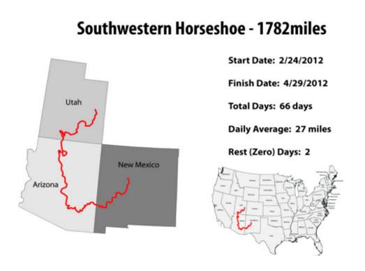
SWH Overview map & stats from my hike (Map by Brian “Beardoh” Ristola).
At a Glance
Distance: 1782 miles (2867 km) approx.
Dates: February 24 to April 29, 2012.
Start : Tower Arch | Arches National Park, Utah
Finish: Sandia Crest | Albuquerque, New Mexico
Tower Arch | Arches NP, Utah | Starting point of the Hayduke Trail and Southwestern Horseshoe.
Route / Distance Breakdown :
- As mentioned above, the Southwestern Horseshoe links together large sections of the Hayduke (HDT), Arizona (AZT) and Grand Enchantment Trails (GET), in one continuous horseshoe-shaped route through America’s southwest.
- The HDT and GET sections of the SWH are more “routes” than trails, consisting of extended sections of cross country travel, interspersed with existing footpaths and little used 4WD tracks. The AZT is an established, more well defined pathway.
- The approximate distances for each of the three segments are as follows: 1. 693 miles (1115 km) for the HDT; 2. 476 miles (766 km) for the AZT, and; 3. 683 miles (1099 km) for the GET.
SWH Journal:
- Click here for journal entries (eleven in total) from my Southwestern Horseshoe thru-hike of 2012.
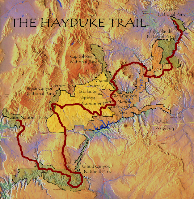
Hayduke Trail Overview Map (hayduketrail.org)
Why the “Southwestern Horseshoe”?
In planning the 12 Long Walks trip (14,342 mi / 23,081 km), I was hoping to experience as much of North America’s incredible natural diversity as I could in the space of 18 months. And one of the areas I was most looking forward to exploring was the Southwest. In particular the otherworldly Colorado Plateau. That being the case, I knew that 600, 700 or even 1000 miles wasn’t going to cut it. Ideally, I wanted something a bit longer in order to really get a feel for the region, and the combination of the Hayduke, AZT and GET seemed to fit the backcountry bill.
A secondary reason for putting this particular trek together was that I liked the idea of finishing the 12 Long Walks with the four longest trails and/or routes. As a lifelong golf and tennis fan, I guess you could say I equated this part of the journey to a “thru-hiking grand slam”! Each of the ambulatory quartet would take multiple months to finish, and to my way of thinking they all represented a distinct part of the US – the Colorado Plateau, the Pacific Crest, the Continental Divide, and the Appalachian mountains.

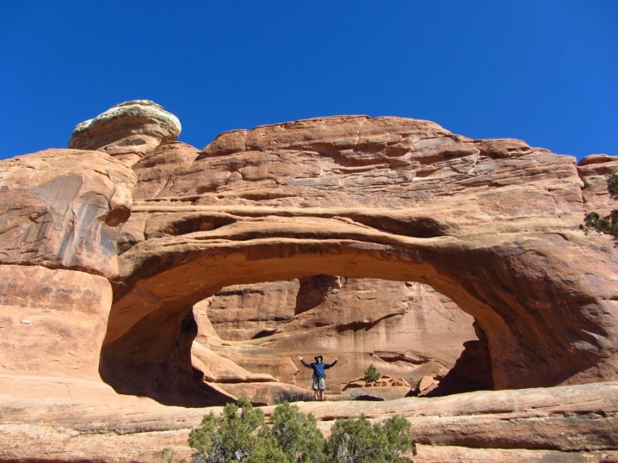
Rock Surfing, Bryce Canyon NP | Hayduke Trail.
Southwestern Horseshoe Junctions
Listed below are the three main intersection points of the SWH. Note that the initial Hayduke Trail mileage from Arches NP to South Rim, will vary according to the number and length of alternates taken during that section:
A. After approximately 693 miles (1115 km), the Hayduke Trail connects with the Arizona Trail at the South Rim of the Grand Canyon.
B. The SWH then stays on the AZT for the next 406 miles (653 km), until it reaches Rogers Trough Trailhead (Superstition Mountains), where it overlaps with the GET.

AZT Overview Map
C. From Rogers Trough to Beehive Well, the AZT and GET are one in the same pathway for 70 miles (113 km). At this point the GET heads east in Putnam Wash, while the AZT continues south. SWH hikers continue on the GET all the way to the finish in Albuquerque.
Below is an overview of planning resources (as of February, 2019) for the three segments of the Southwestern Horseshoe:

GET Overview Map (simblissity.net)
Hayduke Trail (HDT)
Winding its way snake-like way for 812 miles (1,307 km) across the Colorado Plateau, the Hayduke Trail takes place in a one-of-a-kind environment that includes more amazing geological features than any other trail in the world. There are canyons, domes, caverns, hoodoos, rock monoliths, mesas, river narrows, plateaus, caves, natural bridges, slot canyons, and barren badlands. Whew. If you are an experienced backpacker with a love of rocks and wide open spaces, look no further – this is the hike for you.
Resources
- Joe Mitchell & Mike Coronella, The Hayduke Trail: A Guide to the Backpacking Hiking Trail on the Colorado Plateau (2005 edition). The original guidebook from the guys who pioneered the route.
- Hayduketrail.org has a list of Resource links for planning purposes.

Mike “The Gambler” Towne at the confluence of the Green & Colorado Rivers | Utah | Hayduke Trail.

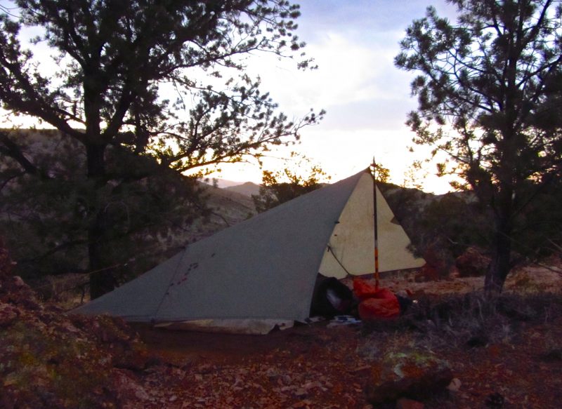
Bunking down in a cave just outside of Young’s Canyon, UT | This was the first long trip upon which I used the Katabatic Sawatch. Seven years and many miles later its still going strong | Hayduke Trail.
- Andrew Skurka, Hayduke Resources Bundle (includes mapset, databook and water information – $25).
- “Buck-30’s” data from his 2013 Hayduke hike. Route notes, water report, GPS info.
- Walking with Wired Hayduke Planning Page: A thorough compilation of resources for all things HDT. The sites author, Erin “Wired” Saver, hiked the Hayduke in 2015.
- Nic Barth Hayduke Trail GPS Track
- Little Package’s Hayduke Trail Mapset – Free Caltopo mapset and general tips on the route from two-time Hayduke thru-hiker, Caroline (aka Puppy).
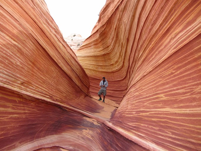
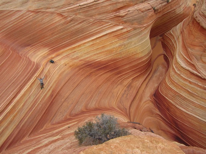
The Gambler at “The Wave” | Coyote Buttes | Hayduke Trail.
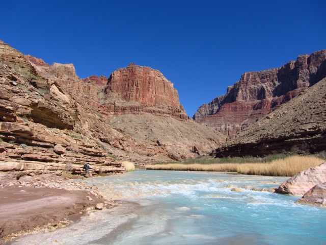
Little Colorado River | Grand Canyon | Arizona | Hayduke Trail.
The emerald hue of the Colorado river contrasts markedly with the turquoise color of the Little Colorado | Grand Canyon, Hayduke Trail.
Arizona Trail (AZT)
The Arizona National Scenic Trail is an 817 mile (1315 km) pathway that spans the entire length of the Grand Canyon State, from the Mexican frontier in the south to the border with Utah in the north.
Resources
- Arizona Trail Topo Maps – A collaborative effort between the Arizona Trail Association (ATA), Brett Tucker/Simblissity and Postholer.com. Consisting of 129 digitalized color topographic maps (1:28,000). Available in printed or digital format (for AZTA members).
- Arizona Trail App – The official navigation app for the Arizona National Scenic Trail, built through a collaboration of the Arizona Trail Association and the creators of Guthook’s Guides hiking guide apps.
- Arizona Trail Association Facebook Page – Up to date information on all that is happening on the AZT.
- Click here to see an informative, well made video about the people, trail maintainers and gateway communities that help to make the Arizona Trail tick.

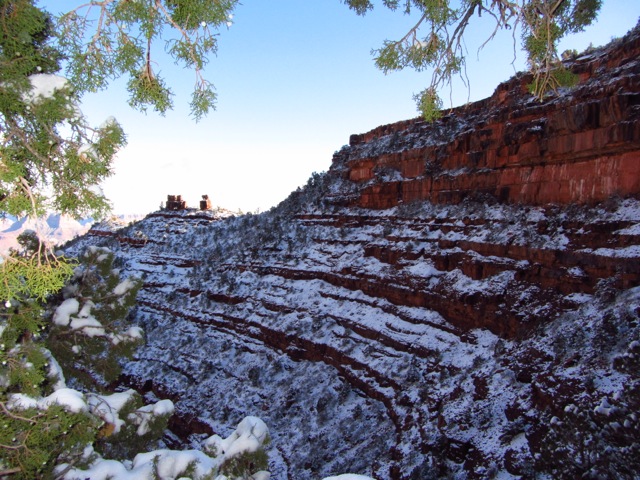
Grand Canyon view from the South Rim – Where the SWH switches from the Hayduke to the Arizona Trail.

Saguaro Cactus | Arizona Trail
Flaming sunset on the Arizona Trail.
Grand Enchantment Trail (GET)
The Grand Enchantment Trail is an approximately 770 mile backcountry route between Phoenix and Albuquerque. In the words of its founder, Brett “The Water Whisperer” Tucker: “……it connects mountains, deserts, canyons, and places of cultural and historic interest. Beginning in the Sonoran desert, the route meanders eastward, crossing unique and diverse Sky Island mountain ranges, deep and water-blessed desert canyons, the pine-studded Continental Divide, and toward the southernmost Rocky Mountains, where it descends dramatically to the outskirts of Albuquerque at its distant terminus.”
Resources
- http://www.simblissity.net/get/ – Tucker’s excellent website is literally a one-stop shop for all of your GET needs. As of 2019, he offers the GET Topo Map Set download for $30. The guidebook, town guide and water report are all free to download directly from the website.
- Buck 30’s GET Overview: Useful planning notes for GET hikers.
- Grand Enchantment Trail Q&A with 2018 thru-hikers Brian and Alison Ristola (aka Beardoh and Sweet Pea).
- Grand Enchantment Trail Facebook Group – Moderated by the trail’s founder Brett Tucker. Contains up to date information from recent thru-hikers.
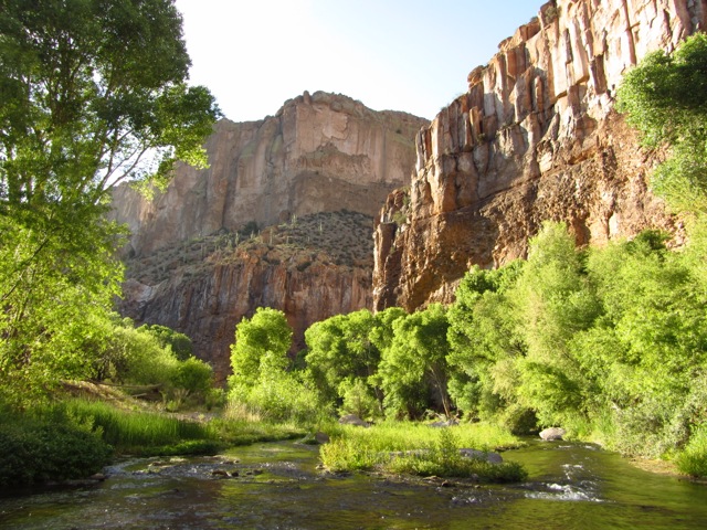
Aravaipa Canyon | Arizona | Grand Enchantment Trail.
My beloved Mountain Laurel Designs Pro Poncho acted as my shelter and rain gear for the Southwestern Horseshoe | New Mexico, GET.
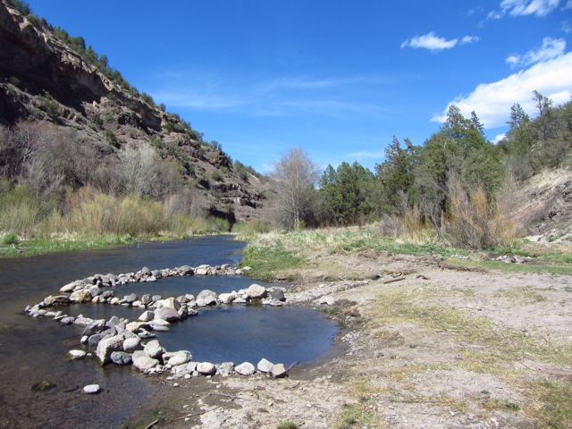
Hot springs on the Gila River | New Mexico | GET
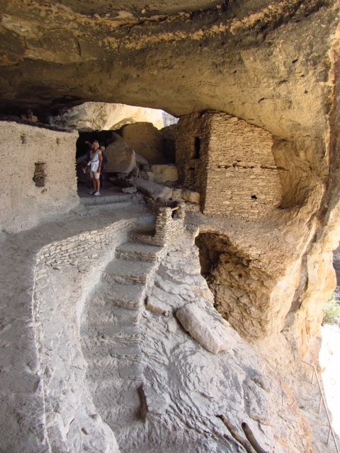
Gila Cliff Dwellings, New Mexico.
Southwestern Horseshoe Q & A
On the off chance that anyone else is interested in doing this route, I thought I’d put together some imaginary questions and answers that may be of help.
How long will it take?
In all likelihood, the majority of folks attempting this hike will have previously completed either the Pacific Crest or Continental Divide Trails. Assuming that the SWH aspirant has a fairly solid backcountry skill set, here are some estimates as to what you might expect mileage-wise in comparison to the aforementioned trails. Note that the figures below factor in rest or zero days, which naturally will drop a hiker’s overall daily average:
- PCT – 22-23 miles per day
- CDT – 20-21 miles ” “
- SWH – 17-19 miles ” “
I estimate that the average SWH hiker will finish the route in approximately 100 days. Due to the weather windows (see below) being potentially smaller than on the PCT and CDT, my advice would be to get your skates on and not take too much (if any) longer than this estimated total.

Cross country desert section near Magdalena, New Mexico | GET | Only a few days from the finish of the SWH.
How difficult is the SWH?
How hard you find the SWH, depends on a number of factors including off-trail hiking experience, pack weight, navigation/route-finding and seasonal conditions. It’s definitely a step-up in difficulty over a regular season Triple Crown trail. However, if you are looking for a challenging multi-month hike through some of the most spectacular natural scenery in North America, then the Southwestern Horseshoe is a great option.
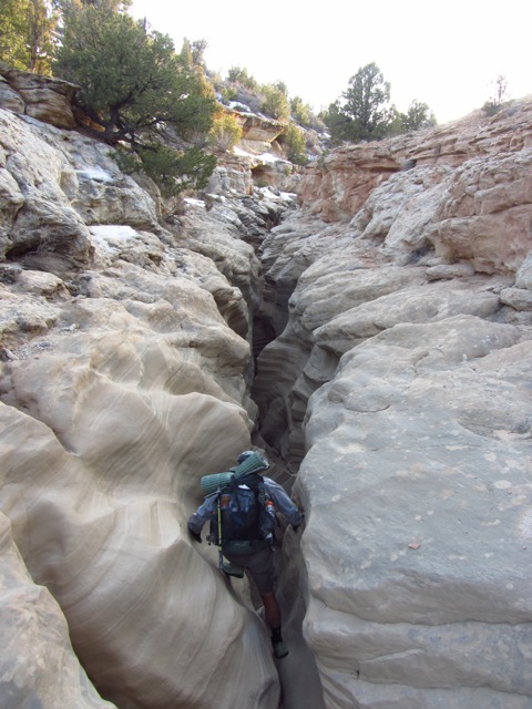
The Gambler descending into Round Valley Narrows slot canyon.
Do I need GPS for navigation?
If you have a good level of proficiency with map and compass and are accustomed to off-trail hiking, then a GPS is not necessary for the SWH. That being said, this is 2019 and the reality is that most (more than 95%) hikers will either have a GPS app on their phone or carry a dedicated unit.
If you choose the GPS option as your principal source of navigation, my only advice is to also bring along paper maps and a compass as well (and, of course, know how to use them). Batteries can die, electronics can fail, coordinates may be off, signals don’t always come through. GPS have their limitations and if you have little to nothing in the way of navigation skills to call on as a backup, then you may well find yourself up poo creek, without a technological paddle.

Swami & The Gambler | Chinese Trail across the Red Benches | Hayduke section of the SWH.
How’s the water situation?
In a word………dryish. That being said, H2O options on the AZT and GET are generally more frequent and of higher quality than on the Hayduke Trail segment. Indeed, in regards to the latter section, the ubiquitous cow patties around almost each and every water source, led me to conclude that Utah is a legitimate contender for “cow poo capital of the US.” Better start looking over your shoulder, Texas.
Resources
- Check out Buck-30’s water chart from his 2013 hike for the latest info on the Hayduke water front.
- For the AZT, see the Arizona Trail Associations excellent water resources page.
- Finally, for the GET, click here to see the frequently updated water report from Simblissity.net.
Almost forgot………some of the “water sources” on the Hayduke are alkaline. It’s actually quite a good litmus test to find out exactly how thirsty you really are.
Resupply
Once again, the Hayduke is the most challenging of the three sections. Expect at least two or three seven day plus carries.
- Hayduke Trail: For an overview of Hayduke resupply options, see Wired’s Hayduke Planning Page. When it comes to trail beta, this woman is Queen. By her own admission, she’s not too great in the navigation department, but what she lacks in map & compass skills, she makes up for in pre-hike research and perseverance.
- Arizona Trail: 1. One of Seven Project Resupply Guide; 2. Long Distance Hiker’s Resupply Guide.
- Grand Enchantment Trail: As for the GET, check out Tucker’s Town Guide for an overview of resupply options.

Joe’s Burger Shack | Tropic, UT | Culinary highlight of the SWH and possibly the meridian of my eating efforts during the 12 Long Walks | In one and a half hours, I consumed two double burgers with the lot, both of which sported two half-pound patties (i.e. 2 lbs of beef total); immediately followed by two pints of Ben & Jerry’s ice cream.
How I resupplied during my SWH hike
Below is a list of my resupply points for the Southwestern Horseshoe. The numbers in brackets represent the mileage and amount of days food I sent via mail drop to each point (i.e. to get me from there to the following resupply). The places in which I purchased locally are noted in blue font:
- Moab – HDT (198 miles / 7 days)
- Hite Marina – HDT (188 miles / 7 days)* (Note: Hite Marina is no longer a resupply possibility. See Walking with Wired’s Hayduke page for alternative options.
- Escalante – HDT (98 miles / 4 days)
- Tropic – HDT (107 miles / 4 days)
- Jacob’s Lake – HDT (102 miles / 4 days) (Note: Jacob’s Lake no longer accepts resupply packages due to storage issues).
- South Rim – AZT (bought at the store)
- Mormon Lake – AZT (bought at the store)
- Flagstaff – AZT (bought at the supermarket)
- Pine – AZT (165 miles / 6 days)
- Superior – AZT/GET (161 miles / 6 days)
- Safford – GET (167 miles / 6 days)
- Gila/Doc Campbells – GET (180 miles / 6 days)
- Magdalena – GET (158 miles / 5 days)
Greetings from the Wave.
What is the best season for the SWH?
This is definitely a spring or fall trip, with a slight overlap into the beginning or end of summer. Given average conditions and an itinerary of around 100 days, I would suggest an early March start date from Arches NP. Prepare for a chilly first couple of weeks.
If you would prefer going in the other direction, a mid-August beginning from Albuquerque could also work, as long as winter doesn’t come too early and you don’t mind a bit of late summer heat in New Mexico. Aim at getting to Arches no later than the end of November.
The Gambler approaching the North Rim of the Grand Canyon | Hayduke Trail.
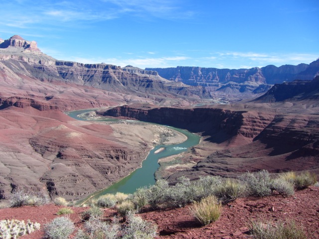
Nankoweap Trail | This gorgeous descent from the North Rim to the canyon floor was one of my favourite sections of the SWH | Hayduke Trail.

The Gambler at the Nankoweap Granaries overlooking the Colorado River | Grand Canyon, Hayduke Trail.
Conclusion
Putting together the 1782 mile (2867 km) Southwestern Horseshoe wasn’t exactly rocket science. It’s basically just large chunks of three already established routes/trails joined as one. All of the cartographic heavy lifting had already been done by the founders of the HDT, AZT and GET respectively.
That being said, I think the distance and timeframe required to complete the SWH, hits that multi-month thru-hiking “sweet spot” that many long-distance hikers search for. Something that an 800 to 900 mile (1287 – 1448 km) trip doesn’t always accomplish. When coupled with the fact that it passes through such a wide expanse of one of the world’s most incredible natural regions, for my money the SWH represents an excellent option for experienced thru-hikers that are looking for their next long-distance challenge.
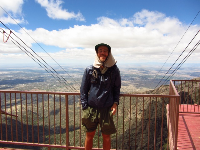
Yours truly on the Sandia Crest looking over Albuquerque | Finishing point of the Southwestern Horseshoe.
Discover more from The Hiking Life
Subscribe to get the latest posts sent to your email.
Hi Cam,
This is super helpful to those of us who dream of even one of these hikes.
I followed Carrot Quinn’s HDT adventure and was impressed with the challenges she & her buddy faced.
I love this terrain, (I’m a 30 yr. desert rat), so this has appealed to me for a while.
Mixing these amazing areas was such a great idea of yours, and after doing a triple crown?!
Happy trails, Scott 2
Hi Scott,
Thanks for the kind words. The SWH immediately proceeded the calendar Triple. It was like a really long warm-up 😉 .
Cheers,
Cam
Congratulations and thank you for sharing your story. My wife and I have trekked in Europe, but while we carry backpacks and aren’t afraid of mountains, we find beds each night. So, I admire what you have done. Happy trails! You should write a book…
Thanks for the kind words. I’ve actually already written a couple of books about different hikes around the world. You can find the links to them in the side bar.
Cheers,
Cam
Thanks for the update. An impressive creation – you make it sound very tempting! A couple of questions, if you can spare a moment:
1) Do you think it would be justifiable solo? I’m experienced at off-trail scrambling and route-finding, but I’ve read a couple of accounts of the Hayduke that make it sound a bit scary. It’s hard to judge whether this is due to the challenges of the route, or the inexperience of the hikers…
2) How much road walking does it involve? I very much prefer projects that keep this to a minimum…
Hey Geoff,
No worries. In answer to your questions:
1. Yes. There are some Class 3 (and the occasional Class 4) scrambles, but nothing too bad. I suspect the “scary” descriptions are more the result of the said hiker’s inexperience in those types of conditions.
2. Yes, it’s possible to minimize the amount of road walking with appropriate route choices. It’s worth noting that most of the “roads” on the Hayduke are of the seldom used 4WD track variety.
Cheers,
Cam
Thanks Cam!
Hey cam, I was just wondering which pack you used on this hike considering there were a couple of longer carries.
Hey Robert,
I used the MLD Burn. You’re right there are some longish carries, and the combined food and water weight occasionally had me hovering around 28/29 lbs total (i.e. approx. breakdown – food 11/12 lb, water 9 lb, base weight 7/8 lb). Not sure I could have fit too much more in.
That said, I think it was a good decision for me personally. I knew that the pack would be fine with six or seven days food carries, and in regards to H2O, over the years I’ve found that I don’t need as much water as most folks, so I figured it would be unlikely I’d have to carry much more than a gallon at any one time. Another factor in my decision to go with the Burn was my start date in late Feb. There was still quite a bit of snow around on the Hayduke section, so a lot of the marginal water sources were ok.
Would I recommend other folks go frameless on the Hayduke/SWH? Probably not, unless they were uber-fit, very experienced in those sort of conditions (particularly knowing how much water they personally need to stay hydrated), and knew with a high degree of certainty how long it would take them to negotiate the long stretches between resupplies and water sources.
That was a lot longer answer than I intended………….
Best of luck,
Cam
P.s. I used the same Burn backpack for all three of the triple crown trails that followed in 2012. By year’s end, the shoulder straps were pretty thin, but otherwise it was still in great shape!
Thanks for the rapid and detailed reply! So it was much a case of suck it up.
I’ve had my burn at 25/6ish lbs and it’s been manageable. And my current base weight is around 6lb so I think I might be ok with the burn
I’m trying to decide on a trail to follow my sobo of the PCT this year. I’m eyeing up the AZT or the HDT. I’ve recently started hiking more routes rather than trails which has drawn me to the HDT. Haven’t fully looked into the hiking season of the HDT so not even sure if it’d be possible to fit it in after the PCT.
All the best,
Rob
This is great! Thanks Cam for the detailed report as always. Unfortunately I heard the Jacob’s Lake is no longer taking resupply packages anymore.
Thanks for the kind words and the update on Jacob’s Lake. I’ll amend the post accordingly.
Cheers,
Cam
I have been looking for something exactly like this once I finish up my last year of college in May 2020. Great resources on this page! I’m looking to find the correct resources to pack, equipment and food !