When many folks think of multi-day hikes in Australia, the first names that come to mind are the Overland, Bibbulmun and Larapinta. All three are great trails. However, none of them are as spectacular, and certainly not as challenging as a full-length traverse of the Arthur Range. Situated in the Tasmanian Wilderness World Heritage Area, the Arthurs is a dramatic collection of jagged quartzite peaks, hanging valleys, and glacier-carved lakes. The rugged nature of the terrain, combined with some of the most extreme weather on the planet, means that this is a route suitable for experienced hikers only. The planning guide below features map recommendations, logistical information, tips, and trekking notes, and last but not least, some incredible images from Viktor Posnov – friend, landscape photographer, and one of the principal contributors to Wanderlust: Hiking on Legendary Trails (Note: All logistical information has been updated as of March 2020).

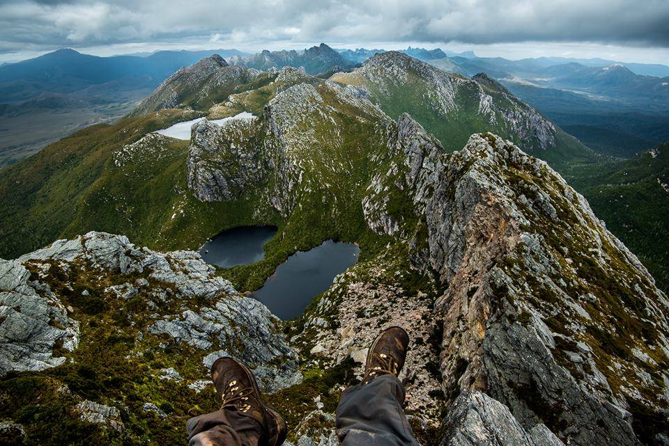
Preparing to take flight over Lake Oberon (Viktor Posnov).
Note: Since 2002 I have made three hiking trips to the Arthurs. The first visit was a hike through the Western section of the range, and the last two have involved full-length traverses of the entire chain. During my most recent visit in 2016, the Arthurs represented the final stage of what was a 24-day traverse of Tasmania’s Southwest Wilderness. For those interested in the Western Arthurs traverse, click here for a comprehensive planning guide.
Details
Distance: 48 miles (77 km)
Difficulty Level: Challenging
Start / Finish:
- Western Terminus: Scotts Peak Dam
- Eastern Terminus: Farmhouse Creek Trailhead
The Western Arthurs from above (Viktor Posnov).
Average Time: 10 to 14 days
- The time needed to do this hike can vary dramatically depending on the conditions, as well as the fitness and experience of the hiker in question. As a general reference, John Chapman, the author of the South West Tasmania hiking guidebook, suggests between 14 and 18 days. Personally, I think this is a conservative estimate. I would say 10 to 14 days would be a more appropriate time frame for most aspirants, given good levels of both fitness and experience, as well as a relatively light pack and a mixed bag with the weather.(Note: Stronger hikers who are carrying a lightweight pack and are accustomed to doing long days in rugged terrain, can complete the traverse in less than a week).
Season:
- December to March. Snow, high winds and heavy rain are possible at any time of year.
Which Direction?:
- Although the hike can be done in either direction, I’d highly recommend going west to east. This places the prevailing winds at your back, no small thing when the Roaring Forties (see below for details) are coming through, and rain is pelting down at a 45° angle.

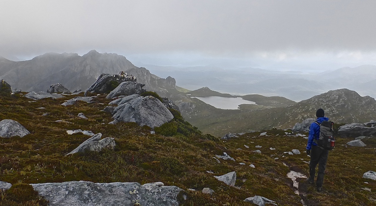
Yours truly about to make the descent to Lake Oberon.
Getting There and Away:
As of 2018, the Arthur Range Traverse is by no means the easiest trek to access. If you don’t have a friend or family member who can pick you up and drop you off, your options are as follows:
- Scott Peak Dam: The western terminus is situated about three to four hours drive from Hobart. Tasmanian Wilderness Experiences run on-demand shuttles, which require a minimum of two people. If you are by yourself and looking to save some cash, consider catching a bus to Westerway from Hobart (approx. 2hrs). From this point, you’ll need to stick your thumb out. It’s approximately 50 km from Westerway to the turn-off to Scotts Peak, and then another 33 km along the well maintained Scotts Peak Dam Road to the trailhead. It has been my experience over the years that as long as you look semi-presentable and have a smile on your face, hitching is pretty easy in Tassie once you’re out of the bigger towns.
- Farmhouse Creek: This is a tricky one. Chances are you will be finishing, rather than starting at the Farmhouse Creek trailhead. That being the case, unless you are very lucky and manage to time your arrival at the trailhead when other folks are either starting or finishing (Note: Roughly the same odds of spotting a Tasmanian Tiger), chances are you will need to walk a little bit more. And by a little bit, I mean approximately 18 km until you hit the paved and semi-regularly trafficked Arve Road. From there you should be able to catch a ride the final 27 km into the town of Geeveston, where accommodation, restaurants, and onward buses back to Hobart can be found.
Farmhouse Creek Trailhead | Eastern Terminus of the Arthur Range Traverse.
Maps & Information:
- TASMAP 1:25,000 – Six topographic maps cover the entire route. They are Burgess, Bobs, Federation, Crossing, Razorback, and Glovers.
- TASMAP 1:100,000 Old River and Huon. Both these sheets are useful for overview purposes, however, when the weather turns nasty, you will be glad you are carrying the 1:25,000 maps. Note: As of 2015, TASMAP has made its topographic maps available for digital download (A$2 each)
- John Chapman’s South West Tasmania includes maps and trekking notes. Now in its 6th edition (2017).
- Western & Eastern Arthurs Traverses Facebook Group – A good source for up-to-date information on hiking conditions in the range.
- Do I really need to take all of that?: In this day and age more and more people are leaving paper maps and compass at home, and having all their navigational eggs in one electronic basket (i.e. their smartphone). Please don’t do this for the Arthur Range Traverse. The terrain and weather in this area is no joke, and if something happens to your phone during the trek, you may well find yourself stranded up poo creek without a technological paddle. My advice is as follows: 1. Download all six of the 1:25,000 maps and the two 1:100,000 maps. Have them on your phone and print them out as well – at the very least the 1:100,000 sheets. Keep all information in sealable plastic bags; 2. Buy Chapman’s book, and take photos of the trekking notes to keep on your phone for reference purposes; 3. Carry a compass and keep track of where you are on your maps at all times.

Sunset at West Portal in the Arthur’s Range (Viktor Posnov)
- What about food and/or resupply?: This is a wilderness trek and there is nowhere to buy food along the way. There is nothing for it but to suck it up, and carry everything you need from go to whoa. While I would never recommend rushing during a hike, due to the rugged nature of the terrain, I would suggest trying to finish the Arthur Range Traverse in eleven days or less. This may mean slightly longer hiking hours than usual, but the payoff is less weight on your back while out on the trail.
- Water: For the most part, H2O can be found in abundance. That said, there is a high-level stretch or two – the Beggary Bumps comes to mind – in which aspirants will need to carry sufficient water for four to five hours of tough hiking. See Chapman’s guide for details.

Brother-in-law, Jonno, on the Southern Traverse section of our 2015 Arthur’s Range hike | It was his first hiking trip to Tasmania, and the weather was dodgy almost the entire time | Not sure he has ever completely forgiven me.
Gear Recommendations:
Shelter: I’d recommend taking a tent rather than a tarp for any trip in the Arthurs. Be sure that it holds up well in a storm. Due to the extreme weather conditions, this is not a hike where you want to be testing out your shelter for the first time. Note that most of your camping will be done on wooden platforms; the exception being the final 19 km stretch between Bechervaise Plateau and Farmhouse Creek Trailhead. Be sure to bring along some extra guyline in order to tie out your tent. There are typically nails and pre-tied pieces of rope along the edges of the platforms which will help to make things easier.
Clothing: When backpacking in cold, wet and windy regions such as SW Tassie, my preference is for multiple lighter layers that dry relatively quickly and retain warmth when wet. For example:
1. Base layer – 150 or 200 Merino wool long sleeve shirt with zip neck.
2. Mid-Layer – A combination of fleece and/or synthetic fiber insulating garments such as the Montbell Thermawrap Jacket, Thermawrap Vest, Patagonia R1 Hoody, and R2 Fleece Vest;
3. Outer Layer – No garment is completely waterproof given extended exposure to extreme wet weather. Working on the principle that damp is better than soaked and being comfortable rather than dry is the priority, I look for rain jackets with the following features:
- A good DWR (durable water repellant) finish;
- Relatively lightweight;
- Quick drying;
- Pit zips for ventilation;
- Adjustable wrist cuffs and,
- Fully adjustable hood with a stiff brim.

The Arthurs arguably represents the ultimate in field tests for rain gear | Yours truly and the Montbell Torrent Flier | Eastern Arthurs, 2015.
Footwear: I’d recommend going with a pair of good trail running shoes. Generally speaking, they will have more stability, support and better traction than normal running shoes, but will be significantly lighter than boots. Whatever your choice, chances are your feet will be wet for at least some, if not most of the traverse.
Pack Weight: I cannot over-emphasize the importance of keeping your pack weight at a reasonable level for the Arthur Range Traverse. In any type of terrain, a lighter pack will translate to a more enjoyable on-trail experience. However, in a rugged environment such as the Arthurs, it makes an even bigger difference, not only in terms of hiking comfort but also in regards to safety. For example, when you are scrambling up and down slippery rocks and root-laden cliffs in the pouring rain, a lighter pack will translate to not only enhanced agility but also free your mind of the burden of a heavy load, so you can focus solely on the job at hand.
This planning guide is not the place for an in-depth gear weight discussion. If you are interested in dropping your base weight without compromising safety (in actual fact you will be increasing it), check out the Gear and Going Light sections of the website (top navigation bar), or take a look at some of the other resources I have listed on Websites for Hikers and Backpackers and Books for Hikers and Backpackers.
Sensory overload on Dorado Peak (Viktor Posnov)
Trekking Notes:
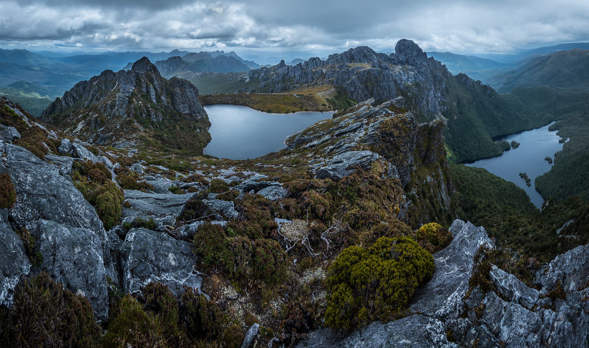
Overview: A relatively short and compact mountain chain, the Arthurs boasts an impressive collection of jagged quartzite peaks, hanging valleys, and glacier-carved lakes and moraines. Approached from the north (i.e. from the starting point at Scott Peak Dam), the range rises dramatically out of the mud-laden button grass plains. It’s serrated profile and sheer rock walls have given many a hiker pause for thought; generally something along the lines of, “what the #*!? have I gotten myself in for?”
Rollercoaster: The majority of trekking in the Arthur Range Traverse will be either steeply up or precipitously down. If you’re looking for a hike in which you can stretch out and cover big distances, it may be best to look elsewhere. In the Arthurs 1 to 1.5 km per hour is generally very good going. That being said, the payoff for all your exertions comes in the form of consistently jaw-dropping vistas, and the satisfaction that comes with meeting and adapting to the rigours of unforgiving environments.
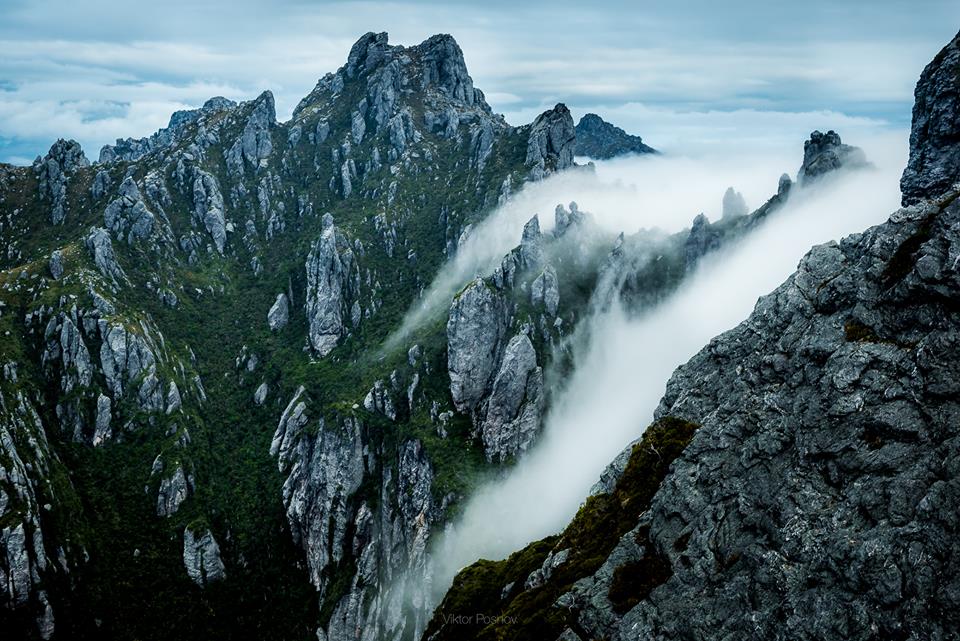
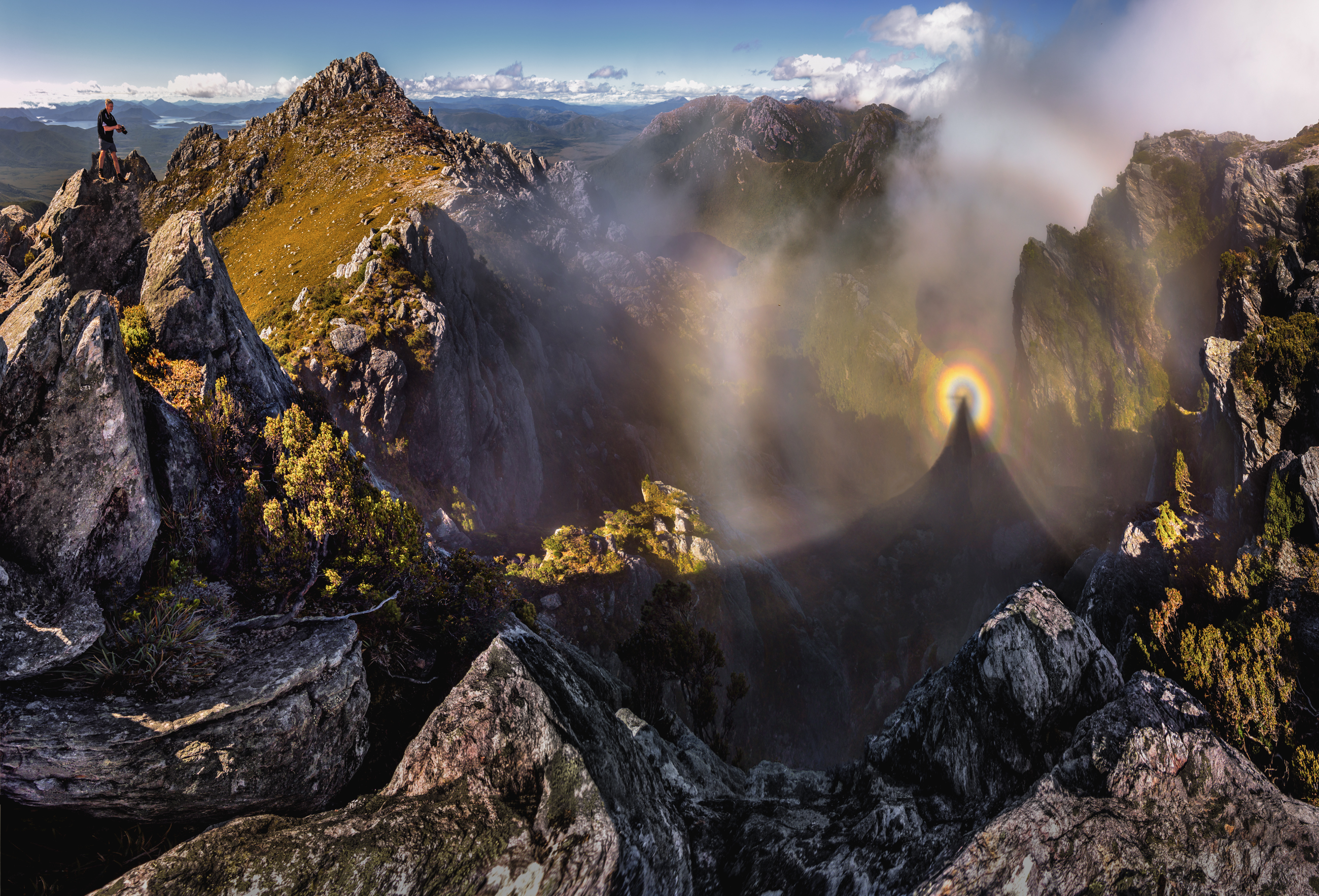
Cloud creeping through the jagged quartzite ridge line (Viktor Posnov).
The Weather: Speaking of challenges, one cannot talk about hiking in Tasmania’s southwest wilderness without making special mention of the weather. On average it rains 250 days per year in this part of the world. And I’m not talking drizzly Seattle or UK type precipitation. The Arthurs plays host to some of the wildest and most unpredictable conditions on the planet. Thanks in no small part to the Roaring Forties – gale-force westerly winds found in the Southern Hemisphere, generally between 40° and 50° latitude – backcountry trips in this range are a barometrical roll of the dice at any time of year. In addition to a storm-worthy shelter and good wet weather gear, an ironic sense of humour is highly recommended.
Windows of Opportunity: The odds are very good that you will encounter dodgy weather at some point during your hike. That said, storms often pass as quickly as they arrive in this part of Southwest Tassie. That being the case, when you are presented with a clear meteorological window, be sure to make the most of it. This occasionally may translate to hiking longer hours, in order to compensate for the other times in which you will need to cut your days short due to inclement conditions.
Mud: With all the precipitation it receives, it is no surprise that there is quite a bit of mud in the low-lying areas around the Arthurs Range. During the traverse the main places you will likely encounter boggy conditions are at the start and finish. Particularly, the Farmhouse Creek Track section between Moss Ridge and Cutting Camp.

Yours truly wading along the Farmhouse Creek Track | If memory serves I was thinking something along the lines of: “Farmhouse creek? Should have been called s***house creek.”
Camping: The challenging nature of hiking in the Arthur Range is slightly mitigated by the fact that there are established campsites situated throughout the route. Most of these are situated in “relatively” sheltered locations. When the elements have taken an inclement turn and/or your energy levels are low, hikers never have to go too far before you can potentially call it a day.
As noted above, the main camping areas in the Arthur Range sport timber platforms. They also have modular toilets, which can be flown out by helicopter when full. Neither of these features is aesthetically pleasing, however, they play an important role in helping to minimise the damage to the Arthurs fragile alpine environment. No small matter, considering the increase in hiking numbers in recent years.

Wild camping in the eastern part of the range | Shelters pictured are the Tarptent ProTrail & the MLD SoloMid XL
Federation Peak: Given fine weather, one of the highlights of a traverse of the Arthur Range is climbing Federation Peak. Arguably Tasmania’s most striking mountain, Fed Peak represents a holy grail of sorts for some in the Australian bushwalking community. During my 2015 traverse, I was unable to attempt the summit due to stormy weather, however, in 2016 the conditions were much improved, and I was able to successfully make the hike to the top.
The direct ascent route is a Grade 5’ish scramble, not technically difficult, but extremely exposed. I’m talking six hundred metres pretty much straight down to Lake Geeves. There’s definitely a pucker factor involved.
The route to the summit is cairned, however, there are a couple of times when the way is anything but clear. Indeed, on more than one occasion I distinctly recall thinking to myself, “Nah, that can’t be it………can it?” Sure enough, after investigating what at first seemed like easier alternatives, I returned to the cairned route.
When you eventually reach the summit, the top is much bigger than you expect and the panorama is spectacular. Given fair to fine conditions, it makes for a great place to have some lunch and take-in the craggy profile of the entire Arthur Range. Yes, you did just come through all of that! Don’t dally for too long, as the weather in these parts is prone to change very quickly.
Note: It’s worth emphasising that Federation Peak should only be attempted in fine conditions. Additionally, if you don’t have a good head for heights or decent scrambling ability, you may want to give this one a miss. People have died on this climb over the years. You can leave your backpack at the base of the peak, and make the ascent with the bare minimum – wet weather gear, water and a couple of snacks. A rabbit’s foot, dream catcher and shamrock may also be a good idea.

Federation Peak (photo jasonmacqueen.com)

The climb up Fed Peak with Lake Geeves below (Photo jasonmacqueen.com)

Yours truly on the summit of Federation Peak.
FAQ’s
During the traverse are there places to bail early in case I get into trouble?
Yes. If you are hiking from west to east – recommended due to the prevailing winds – it is possible to bail out of the Western part of the range at both Epsilon Moraine and Kappa Moraine. If you decide after reaching Lake Roseanne that you have had enough, you can head NE to Cracroft Crossing and then head west back to Scott Peak Dam via the flat but boggy McKays Trail over the Arthurs Plains (Note: This is the route for the Western Arthurs Traverse, which most folks should be able to do in four to seven days). For details on all of these alternatives, see Chapman’s guide.

‘Watching the storm roll in, and then I watch roll away again’; an Otis Redding moment in the Arthurs (Viktor Posnov).
I’m not sure if I have the experience to do a full-length traverse of the Arthurs. Can you recommend easier and shorter options in SW Tassie?
Apart from the aforementioned Western Arthur Traverse, both the South Coast Track and Mount Anne Circuit represent shorter and mellower alternatives. Chapman’s book contains all the information you will need.
Do I need permits to hike in the Arthurs? Am I likely to encounter many other hikers on trail?
As of March 2020, no permits are needed. At both the Scotts Peak Dam and Farmhouse Creek Trailheads there are registers where hikers can leave their trekking details. Be sure to fill these in at the start and end of the trail, as well as leave your trek itinerary with a friend or family.
Jonno heading towards Promontory Lake | Eastern Arthurs, 2015.
In regards to other hikers, during the primary trekking season between December and March, the Arthurs receives a steady stream of foot traffic. Most of this will be in the Western section. You will also likely encounter other hikers around the Federation Peak area.
Do I need to bring rope?
In his guide book, Chapman recommends bringing 20 meters of rope for pack lowering purposes. I disagree. If you’re in good shape, have decent scrambling ability, and your pack doesn’t weigh the proverbial tonne (and really you should tick all of these boxes if you are planning on doing this hike), rope isn’t necessary. Indeed, in my opinion, it will only add more weight to your pack, making an already challenging hike even harder than it should be.
I’ve heard it said that the Western Arthurs is superior to the Eastern section; is this true?
No. The western part of the range is easier to access, and with the exception of Federation peak, it is the more popular part of the mountain chain. However, having hiked the entire range in both directions, in my opinion, the whole chain is equally beautiful, equally challenging, and hikers are equally likely to feel the brunt of the elements, irrespective of whereabouts they are situated between Scotts Peak Dam and Farmhouse Creek.
Eastern Arthurs (Viktor Posnov).
Summary:
Hiking in the Arthur Range is an exercise in patience, perseverance and meteorological faith. If you are afforded an extended stretch of fine conditions, consider yourself fortunate to have witnessed some of the best mountain scenery in Australasia. On the other hand, if a big storm front rumbles through and all you see is horizontal rain and thick fog for three straight days, simply shrug your shoulders, have an ironic chuckle and try to remember that Mother Nature doesn’t have a copy of your hiking itinerary. Either way, hiking the Arthur Range Traverse will be a trip you will never forget.
Related Posts
- Southwest Tasmania Traverse: Stage 2 – The Arthur Range
- Southwest Tasmania Traverse: Stage 1 – The West Coast
- Arthur Range Gear List
- Tips for Hiking in Cold and Wet Weather
Postscript: The following short video was made by BroshOw2 while descending Federation Peak. It contains some colourful (though completely in context) language. I feel like it succinctly sums up what it’s like to go up and down the Fed!
Postscript 2: For more amazing images from the Arthur Range Traverse, see Viktor Posnov’s Western Arthurs and Eastern Arthurs compilations. You can also follow Viktor on instagram, facebook and Flickr.
Thank you for writing this guide. I now have a new dream hike.
Jeepers! Talk about death by selfie. Would have been ironic if you’d fallen with a rope around your neck.
So there is actually a “track” or trail here? Based on your description of the maps and navigation equipment needed, I assumed the route was cross country (often what we do here in Alaska). But then you mention camping on built platforms and access to portable toilets. Was some of the hike off trail and some on?
Great story! Given the exposure to heights and no option for steering clear, I’d be too chicken. I’ll just enjoy your photos.
The photo you reference is courtesy of Jason Macqueen, as is mentioned in the caption. To the best of my knowledge it was taken by one of his companions. Not sure why you would think it is a selfie.
For most of the hike there is a discernible “track.” However, there are also numerous overgrown and technical sections that traverse rocky ridges where the way is not always clear, particularly when negotiated in thick fog, along with driving wind and rain (as is often the case).
The platforms were introduced by Parks to protect the fragile alpine environment; there simply aren’t that many places to camp in the Western part of the range due to its narrow and compact character.
Brrr… Thank you for writing this guide. I now know I’d never have this dream hike.
“There is nothing for it but to suck it up, and carry everything you need from go to woe”.
Shit Cam, I hope you don’t mean woe!
I loved your mauled by tiger pic on Bushwalk.com – I think it was the last time you were there?
Oops, thanks for that. Duly amended.
Yes, Feb/March, 2016, was my last visit. The “mauled by tiger” photo was taken immediately after the West Coast section, and before the “comparatively” mellow Arthurs segment.
Cheers,
Cam
During my time in Aussie I never managed to get excited woth the Overland Track and in the end dismissed it (having spend time in NZ previously didn’t help). Thanks to you and this post I now have very much a feason to come back and further explore the Tassie wilderness. Great job, thanks !!
hi, there is a way most quick to arrive very close with car and walk for some hours and NOT days? thank you and sorry if my question will be silly
Try the Scotts Peak Dam trailhead. From there it is two or three hours to Junction Creek, and another couple to Lake Cygnus.
Hi – we’re looking to do the Arthurs in about 6 weeks’s time. I’ve got a few questions…
You’re saying 77km – is that for the Eastern or Western traverse?
I see your comments on the Eastern being just as beautiful as the Western traverse, but which do you think is the tougher hike?
How much additional time would you allow to summit Fed Peak in good conditions? I assume it’s a significant side trip from the main trail?
Thanks in advance!
That’s the distance for the full traverse of the range (i.e. both east and west) that Chapman lists in his book. Both sections can be challenging; perhaps the eastern part is a little more difficult given an equal run with the weather. In regards to Fed Peak, allow anywhere from one to three hours depending on how much time you want to spend on the summit.
Hi Cam – great guide.
A mate and I are ramping up to do the East Arthur Traverse in about 6 weeks time. You cite 77km as the distance – is that for the Eastern or Western Traverse?
From the map the Western Traverse looks significantly further and tougher – is that the case?
The full traverse. The W.Arthurs “lollipop” shaped route is easier than the full traverse. If you plan on doing the latter, you should pick up a copy of Chapman’s excellent SW Tassie guide; chances are it will answer all your questions.
In the late sixties and early Seventies I did Federation once and the Western Arthurs twice. The latter Western Arthurs was light weight and took 24hrs. Junction Hut, up moraine A and down K and back to Junction Hut. Looking back at all the various blogs on these trips now I say to myself. Nah, couldnt have. I have had a really blessed life and I thank all my bushwalking companions. Then and now.It truly is a Bushwalkers paradise.
Thankyou.
Well I got kyboshed having gotten half way through day 6 through the eastern over the Andromeda Crags and almost over Centauri Ridge when the fires in the park forced us out via a helicopter evac. Very sad for the park and I was bitterly dissapointed not to finished the cream of the walk.
Coming back as soon as possible.
The most spectacular and challenging walk I have done so far. This is one where the pain (Moss Ridge up) and pucker factor (some of the Southern traverse) is so worth it.
Hi Andrew,
Sorry to hear about the fires; it’s unbelievable what has been happening in Tassie this summer. The Southern Traverse and Fed Peak is a pretty amazing area. All the best for your future return!
Cheers,
Cam
Hi.. how many days it would takes if i start from western athur range(scotts peak dam) and go to federation peak and go back to scotts peak dam again..?thank you
It depends on a bunch of factors such as fitness, pack weight, experience and weather.
For all interested in this walk, Western Arthur’s traverse is closed due to bushfire damage east of moraine k (towards lucifers ridge and the eastern Arthurs). Currently only open between moraine A and K only, as well as approach from Scott’s Peak Dam. Eastern Arthurs Range is closed.
This includes closure of the Mt Anne circuit.
Check parks and wildlife website for closures and make sure by calling the visitors centre at Mt Field days before you leave as things can change quickly.
Thanks for the update
Hi Cam,
Thanks for writing this guide, it’s awesome. My Grandfather and Great Uncle were the first to ascend Fed Peak in ’49. Hopefully in the summer of 2021 we will be able to get another Elliott up there.
I’d love to have a chat with you regarding the adventure.
Hope that you are well.
Hey Greg,
Thanks for the message! That’s very cool about your Grandad and Great Uncle. Hopefully, by next summer things will have returned to normal and you’ll be able to follow in the footsteps.
Cheers,
Cam
Hey Cam
Soo great to read about your epic adventures. I’m from Nz and currently living in Rockhampton. Totally missing all my Nz terrain and adventures.
Totally keen on the full 69 km western Arthur’s range hike.
Was thinking of doing by my self. As I have had bad experiences in the past with hiking buddy’s. Would you do it by your self or take someone with you?
Hey John,
Thanks for the message. Whether you go alone or with someone depends on multiple factors, including experience and personal preference. Personally, I did it once by myself as part of the Southwest Tassie Traverse and another time with a mate.
Cheers,
Cam
Hey Cam,
Great reading, thank you.
My hubby is very keen for a trip to Lake Oberon, such a beautiful place. We would only go to Lake Oberon from Scotts Peak and return. From what I read it can be very slow going due to mud etc, and about 18.5 km each way.
Would you reccommed 1 or 2 nights, ie 2 or 3 days? We live in Tassie so fully understand the ever changing weather conditions.
Thanks
Paula
Hi Paula,
Thank you for the kind words. If you have the time, then 2 nights/3 days would most likely be the most comfortable option. Try to spend at least one night at Lake Cygnus or Lake Oberon. If the weather takes a turn for the worse, its worth noting that Junction Creek provides a more sheltered (though far less scenic) option. All the best on your trip!
Cheers,
Cam
Hi, very interested in your Western Arthurs walk. In Xmas 1953/Jan1954 attempted western arthurs walk. Had to walk in and out packing for 15 days . Got along to about Mt Rhondo from the Western Portal and had to pull our due to weather delays. Followed a ridge down to the east to the river and walked out north to Miena and public transport. The dam and roads you mention were not there at that time. Entry was from a walk into Blakes Opening over Mt Picton down to Craycroft crossing and on to the Arthurs over the Arthur plains. A trip I will always remember for enjoyment and grandeur. I was part of the Bosco Rover Crew from Melbourne and were noted for our adventurous walks.
Hi Jack,
Thanks for sharing your story. The Arthurs was certainly a lot harder to access back in those days; just getting there and away sounds like an incredible journey in itself.
Cheers,
Cam
Hmm, maybe you have always been blessed with ok’ish weather in Tasmania but I wouldn’t wanna be following your gear advice if it all went to hell. A rope in the rugged zones of Tassie is a bloody good idea.
Over the many years I’ve been bushwalking in Tasmania I’ve encountered all types of conditions. For the reasons I mention in the article, I don’t think a rope is necessary in the Arthurs.
Thank you so much for all your content, it is super helpful.
I was thinking of going in mid to late October this year. What do you think about going at that time of the year? I don’t mind the cold.
Thank you
Nic
Hey Nic,
Thanks for the kind words. September/October have the reputation for being particularly inclement in the Arthurs. Apart from the cold, I hope you don’t mind the rain and wind as well! That said, the weather is a crapshoot at the best of times in that range. If you have the requisite gear and experience, along with a dose of luck, it may end up being a great time of year to go.
Cheers,
Cam
Cam, thanks for the guide.
I just did the whole trip W – E inside a week. Everything was open and I was able to take advantage of great weather conditions.
If I hadn’t seen your site I wouldn’t have thought of trying it in the10 day window of availability I had.
Thanks again
Hey Pat,
Glad you found the guide to be helpful. Congrats on your trip (and your good fortune with the weather)!
Cheers,
Cam
Hi Cam, thanks for this terrific guide, has been my go to for a while. How slow going is the hike from Moss Ridge onwards? I am starting the traverse in a couple of weeks but have not quite locked down travel back to Hobart at the end. I am assuming with the Tahune visitor centre 20km away there is a healthy flow of traffic for getting a hitch back into town once you hit the main road. What was your experience of getting back to civilisation at the end of this walk, was the logistics difficult?
Hey Chris,
Thanks for the message. Regarding your questions:
1. Moss Ridge – Generally speaking, it’s muddy and steepish. I wouldn’t call it swift-going, but it’s not too bad;
2. Farmhouse Creek Trailhead – I was very fortunate; a friend who more or less knew my finishing time came and picked me up as a surprise. As you mentioned, chances are you’ll have to hoof it all the way to the main road, from where you should be able to catch a ride to Geeveston (or maybe Hobart).
All the best on your trip!
Cam
Thanks Cam. How much MacGyvering is required to set up a mid on the wooden platforms in the Arthur range? I am considering taking a free standing tent but do prefer a mid generally. Any tips on how to get a decent pitch of a mid when camping on these platforms?
Hey Chris,
No worries. Go with the mid rather than the free-stander. Setting up on the platforms is pretty simple; just be sure to carry some extra-long guylines.
Cheers,
Cam
Thank you Gam for this great guide.
Just a simple(and potentially silly) question. Have you ever hiked the Arthur range Solo?
Cheers
Alban
Hi Alban,
Thanks for the feedback.
Regarding your question, I hiked the Arthur Range solo in 2016 as part of the Southwest Tasmania Traverse (https://www.thehikinglife.com/2016/05/southwest-tasmania-traverse-stage-2-the-arthur-range/).
Cheers,
Cam